Urban Activation: case study of downtown Itaguaí-RJ of IAAC – Instituto de Arquitectura Avanzada de Catalunya developed at Maestría en Ciudades: Urbanismo próximo in 2021 by: Architect and urban planner Vinicius De Tomasi Ribeiro. Profesores Belinda Tato y Jose Luis Vallejo
#urbanmobility #humanmobility #urbanactivation #riodejaneiro #itaguai
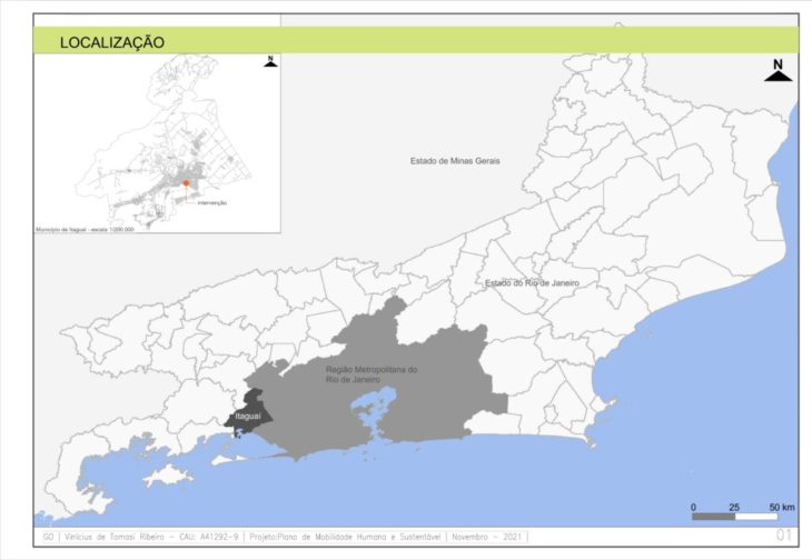
The study is located in the city of Itaguaí, state of Rio de Janeiro, Brazil. The municipality of Itaguaí covers an area of 282.606 km². The municipality is located in the state of Rio de Janeiro, in the region between Baixada Fluminense and Costa Verde region. The municipality is totally inserted in the Sepetiba Bay Basin, in which two distinct revealing characteristics can be observed: to the north and west are the great mountainous elevations and to the south and east the flat region where marshy and swampy lands predominate. Itaguaí is part of the Metropolitan Region of Rio de Janeiro and is 69 km from the state capital. Its strategic geographical position has attracted throughout its history investments in infrastructure, such as the Port of Itaguaí and the Metropolitan Road Arch, encouraging the installation of large logistics and high technology companies. Its estimated population (IBGE, 2020) is 134,819 people, for a vehicle fleet of 52,891 (DENATRAN, 2020), totaling an average of 39.23 vehicles per 100 inhabitants.
The company that I manage is developing a Sustainable Human Mobility Plan. The Plan is being elaborated, however, there is a set of information that has already been agreed upon by the municipality, among them the vision, the general guidelines, the goals, and the effective actions to achieve them. In addition, a set of technical and community surveys were carried out, which contributed so that the technical team could build better arguments and justifications in their proposals. We highlight one item of the research results which identified the city center – more specifically the “calçadão” – as an element of the city that has lost its identity (reference). Because of this, our chosen object to advance in this discipline was the “calçadão”.
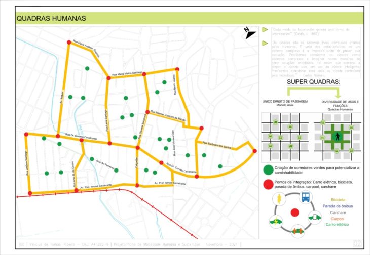
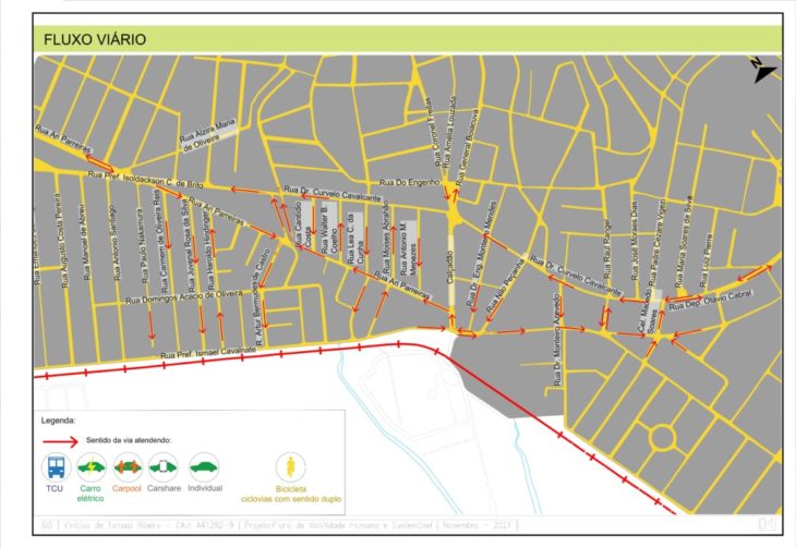
We started the analysis through the guidelines of the superblocks, conceptualized by our proposal as “human blocks”. We located the main connection points between transportation modals. We identify points (nodes) within the human blocks that can absorb the green corridors proposal. We built a set of analyses based on 7 (seven) concepts called urban activation: human scale, human mobility, green areas/urban gardens, singularity and identity, urban vitality, diversity of uses, and active facades. We made studies of the motorized transport flows aiming to understand the behavior of the vehicles in the proposed system.
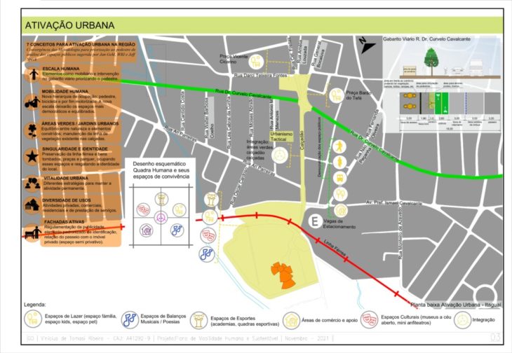
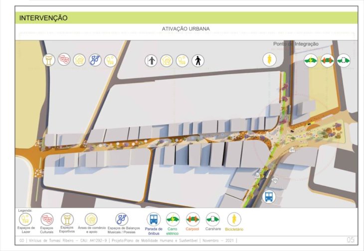
After the respective analyses, we identified the potential to unify 4 (four) public areas: Vicente Cicarino Square, Barão do Tefé Square, the Calçadão and the Expo space. We built a proposal to unify these spaces through coexistence spaces (leisure, culture, sports, commerce and support, integration) aiming to increase the permanence and coexistence time among the residents.
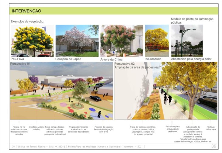
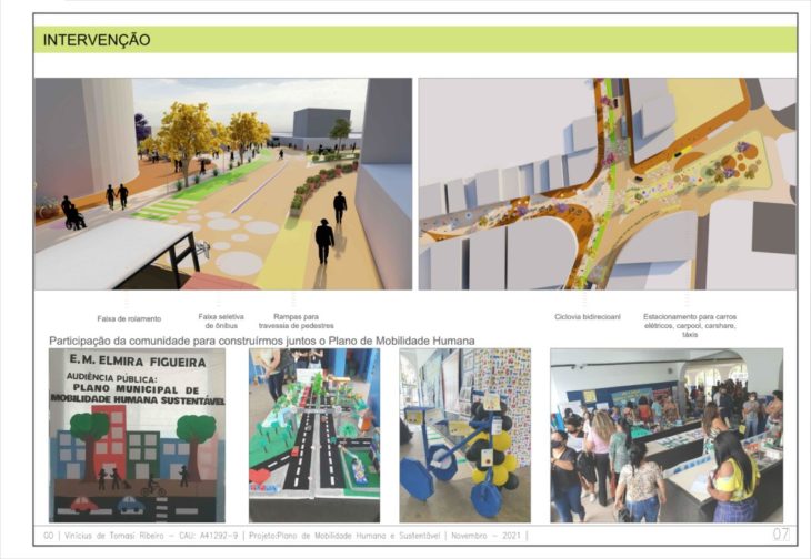
Besides the concern with the coexistence space, the proposal also suggests democratizing the public space – streets – with the expansion of sidewalks, construction of bike lanes, and prioritizing public transportation.
The proposal is not ready. It is a process of construction, between the academic exercise and the local reality. Much still needs to be analyzed.
O estudo é localizado na cidade de Itaguaí, estado do Rio de Janeiro, no Brasil. O município de Itaguaí contempla uma área de 282,606 km². O município está localizado no estado do Rio de Janeiro, na região compreendida entre a Baixada Fluminense e a região da Costa Verde. O município está totalmente inserido na Bacia da Baía de Sepetiba, na qual se observa duas características de revelo distintas: ao norte e a oeste, encontram-se as grandes elevações montanhosas e a sul e a leste a região plana predominam terrenos alagadiços e pantanosos[1]. Itaguaí faz parte da região Metropolitana do Rio de Janeiro estando a 69 km da capital do estado. Sua posição geográfica estratégica tem atraído ao longo da história investimentos em infraestrutura, tais como Porto de Itaguaí e o Arco Rodoviário Metropolitano, incentivando a instalação de grandes empresas de logística e alta tecnologia. Sua população estimada (IBGE, 2020)[2] é de 134.819 pessoas, para uma frota de veículos de 52.891 (DENATRAN, 2020)[3], totalizando uma média de 39,23 veículos a cada 100 habitantes.
A empresa da qual administro está realizando o Plano de Mobilidade Humana Sustentável. O Plano está sendo elaborado, no entanto, há um conjunto de informações que já estão acordadas pelo município, entre elas a visão, as diretrizes gerais, os objetivos e as ações efetivas para atingi-los. Além disso, foi realizado um conjunto de pesquisas técnicas e comunitárias das quais contribuíram para que a equipe técnica pudesse construir melhores argumentos e justificativas em suas propostas. Destacamos um item do resultado da pesquisa na qual identificou o centro da cidade – mais especificamente o “calçadão” – como um elemento da cidade que perdeu identidade (referência). Em função disso, nosso objeto escolhido para avançar nessa disciplina foi o “calçadão”.
Começamos as análises através das diretrizes das superquadras, conceituada pela nossa proposta de “quadras humanas”. Localizamos os principais pontos de conexão entre modais de transportes. Identificamos pontos (nós) dentro das quadras humanas que possam absorver a proposta de corredores verdes. Construímos um conjunto de analises alicerçada em 7 (sete) conceitos chamados de ativação urbana: escala humana, mobilidade humana, áreas verdes/jardim urbanos, singularidade e identidade, vitalidade urbana, diversidade de usos e fachadas ativas. Fizemos estudos dos fluxos dos transportes motorizados visando entender o comportamento dos veículos no sistema proposto.
Após as respectivas analises, identificamos o potencial de unificar 4 (quatro) áreas públicas: Praça Vicente Cicarino, Praça Barão do Tefé, o Calçadão e o espaço da Expo. Construímos uma proposta de unificação desses espaços através de espaços de convivência (lazer, cultura, esporte, comércio e apoio, integração) visando aumentar o tempo de permanência e convivência entre os munícipes.
Além da preocupação com o espaço de convivência, a proposta também sugere democratizar o espaço público – ruas – com a ampliação das calçadas, construção de ciclovias e priorização ao transporte público.
A proposta não está pronta. Ela é um processo de construção, entre o exercício acadêmico e a realidade local. Muito ainda precisara ser analisado.
[1] GEOGRAFIA DE ITAGUAÍ, 2020. Disponível em:
https://www.achetudoeregiao.com.br/rj/Itaguai/localizacao.htm
. Acesso em: maio 2021.
[2] INSTITUTO BRASILEIRO DE GEOGRAFIA E ESTATÍSTICA – IBGE, 2020. Disponível em:
https://www.ibge.gov.br/cidades-e-estados/rj/itaguai.html
. Acessado em: maio 2021.
[3] MINISTÉRIO DA INFRAESTRUTURA. Frota por município (2020). Disponível em:
https://www.gov.br/infraestrutura/pt-br/assuntos/transito/conteudo-denatran/frota-de-veiculos-2020.
Acessado em: maio 2021.Apresentação Final modulo 1 – Vinicius Ribeiro – Ecosistema Urbano