Introduction
Puerto Rico is found in the middle of the Antilles Arch, which runs from the State of Florida (USA) to Venezuela and, ever since the Spanish-American War, is a Colony of the USA. The island nation is nestled between the Island of Hispaniola (where the Dominican Republic and Haiti are found) and the US Virgin Islands. San Juan is the Capital city the Island.
San Juan is located in the northern shore of Puerto Rico and its territory expands southward, up into the lower mountains of the Island. The majority of the city’s expansion occurred throughout the 20th century. In a sharp contrast with urban design policy established by the Spaniards, the modernist city proposed by US’s policy and influence favored the development of decentralized, low density neighborhoods. The rapid expansion of the City in the Post War era was marked by all the features a low-density city requires to work – extensive highways and roads, a myriad of cars and malls.
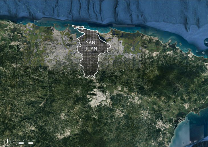
San Juan City
Urban Analysis
Complex interdependencies between water and city
“While San Juan grew, its relationship with its water became ever more complex. Puerto Rico, San Juan included, has a tropical climate. With an annual rainfall of 172” (2.81L) [1]water is an ever-present variable to deal with. A large portion of San Juan’s territory is located in the lower laying lands of the coast. Prior to the modernist expansion of the city, San Juan’s creeks and rivers where abundant. At the shores, large mangrove forests covered the landscape and provided protection from storm surges. The expansion of San Juan relied heavily on hard engineering strategies for water management. Roads where built over canalized streams, mangroves where cut and low-lying lands where filled and built on. Naturally, the inability of these hard strategies to adapt to changing weather patterns and extreme weather events where proven quickly. Flooding, in many areas of San Juan have been common since their construction
[1] Runkle, J., K. Kunkel, and L. Stevens, 2018: Puerto Rico and the U.S. Virgin Islands State Climate Summary. NOAA Technical Report NESDIS 149-PR, 4 pp
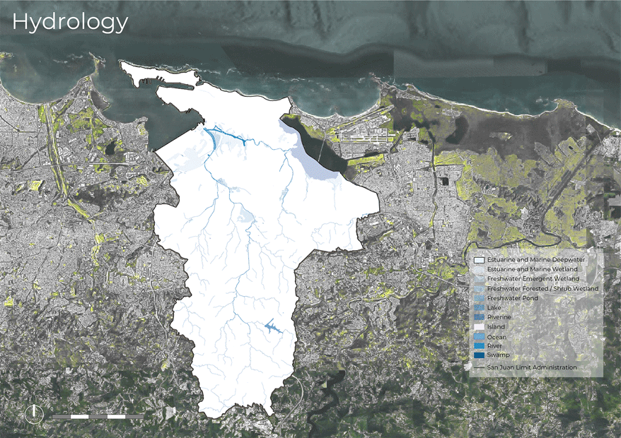
Hydrology System
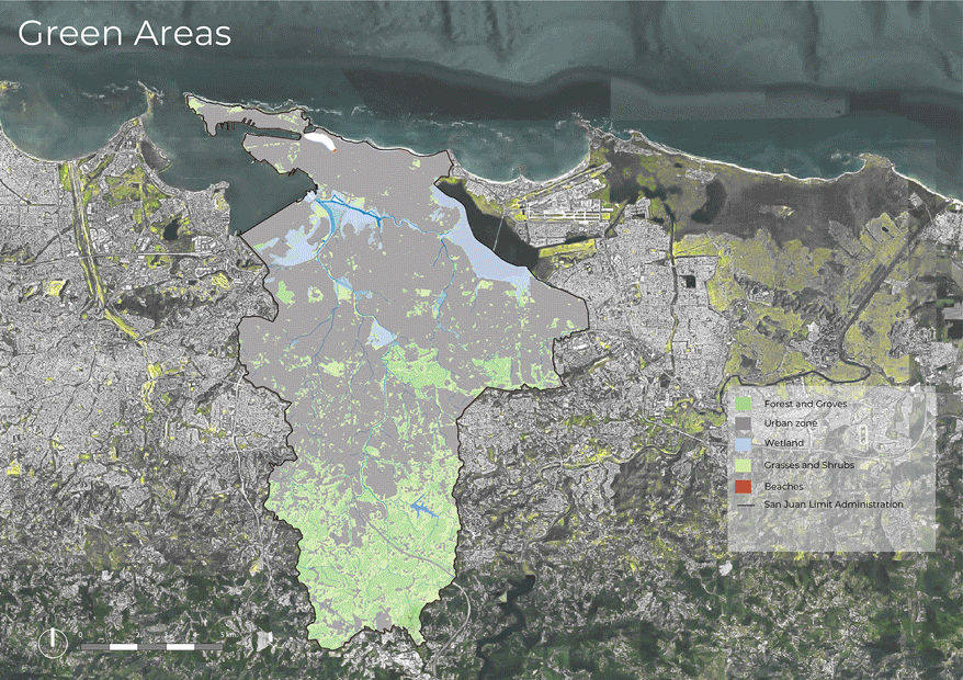
Land Use Patterns
We could categorize San Juan’s land use into three main portions: The Coastal Area, The Suburbs and its rural mountainous part. San Juan’s urban density is most intense in its coastal zone, while its suburbs are characterized by low-density gated communities, and its mountainous part is mostly rural. San Juan’s Land Use is directly affected by its proximity to the coast, and its primary economic sector: The Service Industry. Near the Coastal Area, we find the Colonial Quarters and the first expansions of the modern city. The neighborhoods in these areas are open to the pedestrian, can sustain high population densities and hold most of the cultural spaces of the City (theatres, museums, etc.). On the other hand, the development of suburban gated communities have been a hot commodity for the city’s middle class ever since they began being offered. They city’s suburbs are responsible for most of the urban footprint. The rural part of the city is characterized by scattered single family dwellings on the edges of communal paths.
Urban Analysis
Proposal
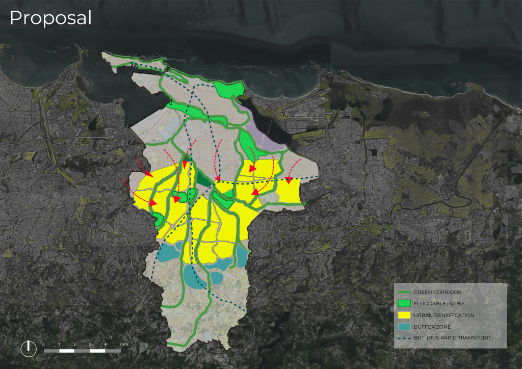
Puerto Rico is no stranger to the effects of Climate Change. The 2017 Hurricane Season brought the island to a standstill. Hurricane María’s damages left the island without electricity and running water for many months and its death-toll almost reaches 5,000. The increase in frequency and strength of tropical storms, and the effects of sea level rise are variables that the cities form, and fragile infrastructure cannot absorb or resist. Our proposal is a response to NOAA’s projected future flooding scenarios. San Juan’s adaptation to Climate Change must begin by reassessing its relationship to its water flows. Rivers and low-lying lands will require more space as they move downstream, we propose to move the city away from water bodies. Where vulnerable urban space once stood, we propose green corridors that integrate natural infrastructure to help buffer the city from flooding. On the other hand, we propose to retrofit low-density developments into healthy, medium-density, urban developments.
Proposal
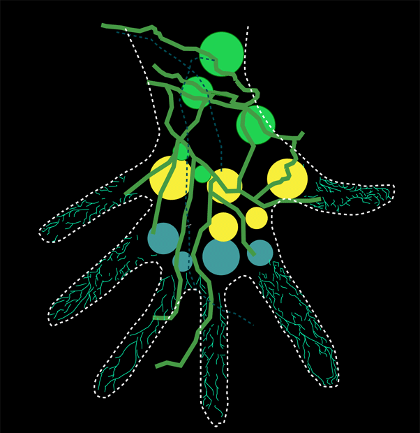
Logogram
The city of San Juan grew in, and around its water bodies. While the impact of the city’s sprawl has reduced the amount of streams and rivers, the form and direction of the city still presents the carvings of the main waterways. As many coastal cities, San Juan’s expansion spreads out from its lowlands, bordering its waterways up towards its rural territory. The spread suggests an open palm- half human, half non-human. This cyborg hand is organized by the bloodline, its veins, and the built space as its bones and muscles.
Logogram
Complexity and Interdependence: Adapting San Juan to future Flooding Scenarios is a project of IAAC, Institute for Advanced Architecture of Catalonia developed at Master in City & Technology in 2020/21 by students: Kevin Aragón, Mario González, and Faculty: Manuel Gausa, Nicola Canessa & Giorgia Tucci.
