Water we talking about? reconnects a dialogue between the city, the citizens, and their water by creating natural, democratic flood risk management systems perpetuated by the inhabitants of Lagos, Nigeria.
Climate Change and water risk
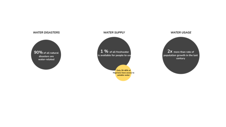
Less than 1% of all freshwater available for people to use is about 12,500 km3 of water, amounting to 6,600 m3 per person/year. Only 48% of the inhabitants of the urban and semi-urban areas of Nigeria and 39% of rural areas have access to potable water supply.
Global water demand for all uses, presently about 4,600 km3 per year, will increase by 20% to 30% by 2050, up to 5,500 to 6,000 km3 per year. By 2050 the global population will increase to between 9.4 to 10.2 billion people. Most of the population growth will occur in Africa.
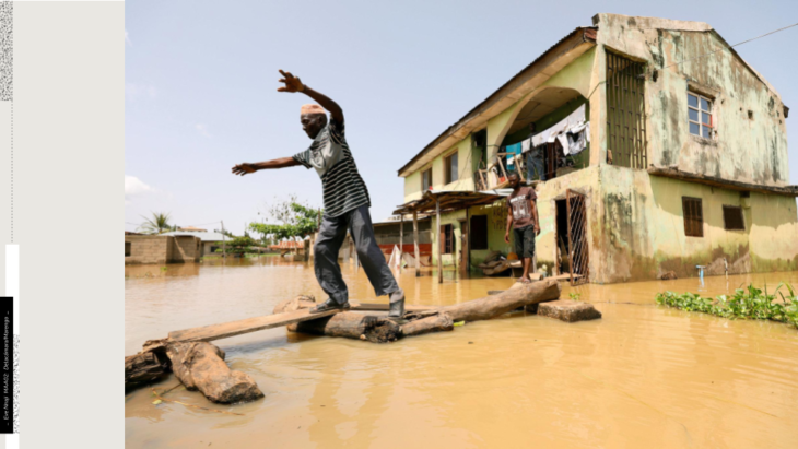
Lagos, Nigeria is undergoing rapid urbanization with a 13 million population growing at 3.2%. This urbanization has led to a 35% increase in flood economic risks and 5.3 billion euros in economic damage. Approximately 70% of the city’s population lives in lower income areas characterized as slums. These vulnerable areas consisting of structures composed with temporary and second-hand elements suffer the most during floods. With increasing floods, an increasing population, and decreasing water stability, there is a clear water disconnect and an imminent water crisis.
Water we talking about? reconnects a dialogue between the city, the citizens, and their water by creating natural, democratic flood risk management systems perpetuated by the inhabitants of Lagos, Nigeria.
How can the understanding of hydrological aspects and the decentralization of this information be used to transcend recurring problems plaguing the region’s ecological systems.
Regional Flood Causes
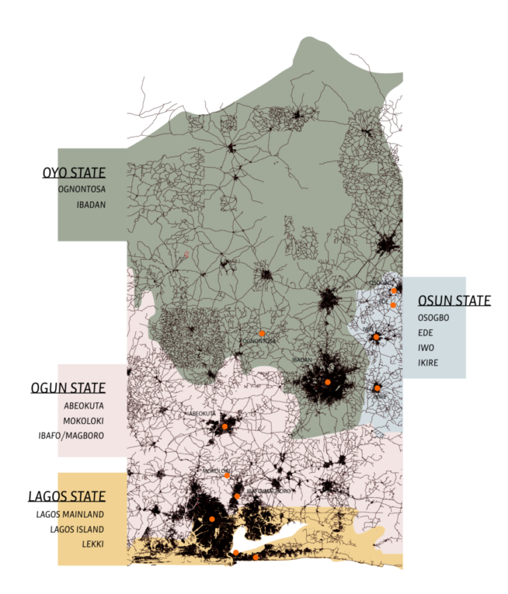
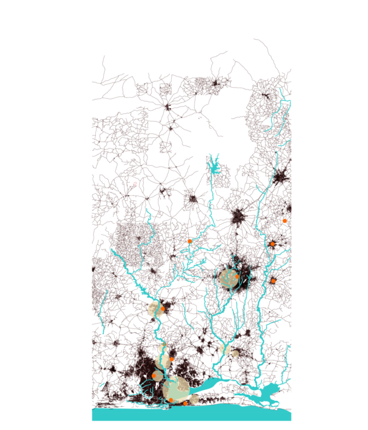
The major rivers intersecting Lagos, Osun, Ogun, and Ogbere are fed by lakes and reservoirs upstates. These receive their water from rain and surface runoff which flow into the rivers and move down to the Lagos and Lekki lagoon and finally the Atlantic ocean. This map identifies the region’s flood hotspots, according to several studies. These spots are mostly located in major cities and areas closer to the sea level.
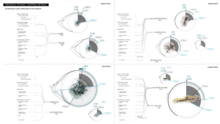
A data table was then created based on population, economic activities, and geographic information, in order to compare the cities to this diagram.

To visualize the collected data, a metric was created to show the city’s size, average rainfall, and elevation along with its water consumption to create an understanding of its relationship with rainwater. This exercise mostly confirmed that flooding in urban areas is linked to heavy urbanization rather than more natural causes.
Rapid urbanization not only creates impermeable surfaces, it cripples a city’s natural drainage systems, the rivers, from functioning. The urbanization of Lagos has led to the solidification of waterways that need room to transform and accommodate for changes in flow velocity. Straightening of these waterways has disabled this ability.
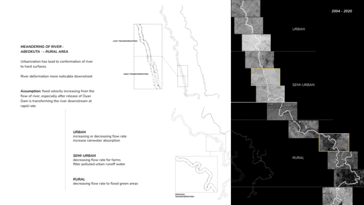
When studying a section of the Ogun river that runs from Abeokuta to Lagos, we see the river’s transformation clearly. The waterway downstream the urban area meanders substantially due to the high discharge output coming from the straightened channels. The pastoral waterways meander less due to the heavy forestation that stabilizes the river’s planform. This illustrates the linear impacts of upstream activities on downstream environments.
Water as a resource (city and citizen water relationship)
It is evident how rapid, unplanned urbanization has led to urban flooding and the crippling of the river. But what about the inhabitants of the city? What role do they play in this narrative?
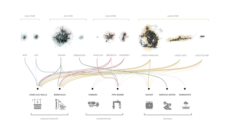
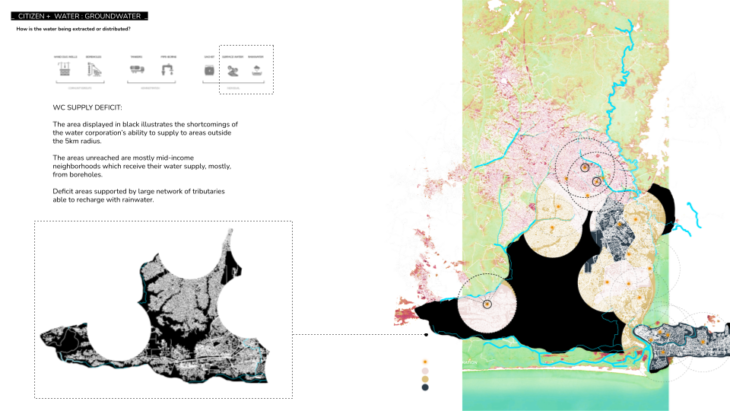
When looking at water as a source, most of the cities rely heavily on hand dug wells and boreholes rather than surface water. High income areas rely on boreholes, while low income areas rely on pipe-borne. In terms of surface water, Lagos does not consume it due to extremely low quality. So how are the citizens using the rivers as a surface water source?
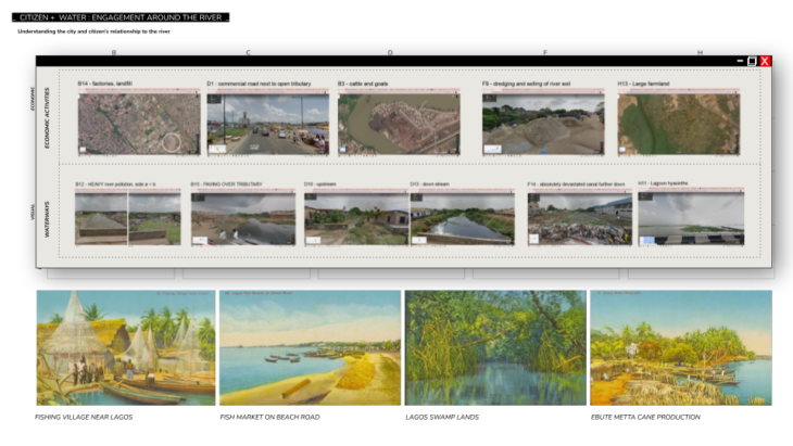
An urban analysis was conducted by splitting all the waterways into segments and utilizing google street view to investigate the activities taking place around the waterways. Usage drivers such as economic activities were plotted on the map. The activities around the river such as animal farming, car repair, and dredging for soil, revealed that the river was being used as a miscellaneous resource simply because of its openness.
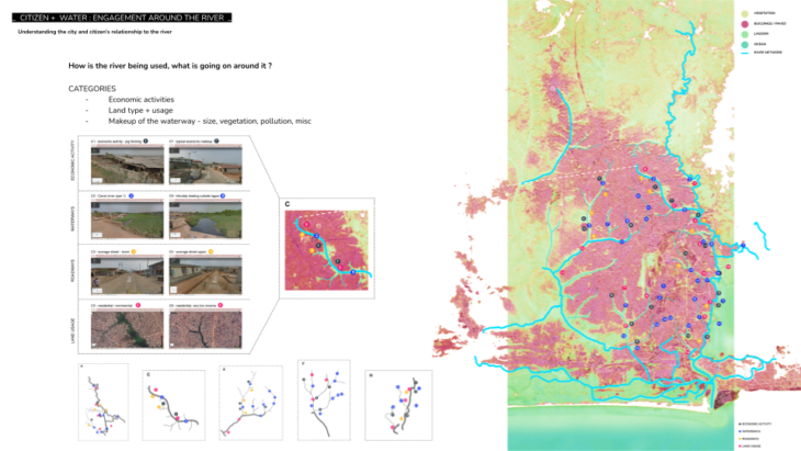
The river has become the backyard of the city, making it susceptible to an uncoordinated range of activities.
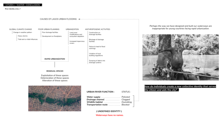
At this point, the river takes on a disconnected function and with various unaligned usages the river undergoes an identity crisis.Perhaps the way we have designed and built our waterways were actually inappropriate for young countries facing rapid urbanization. So, how do individuals create a collective identity that restores the function of the river?
Democratic Flood Risk Management
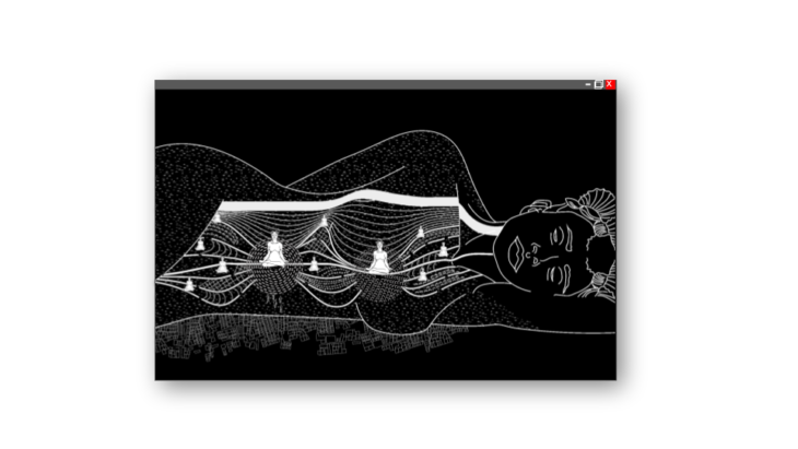
Mami Wata, meaning mother of water, is a popular water deity that is known by most of the tribes in Nigeria. She controls the river and uses the water and ecology in order to reward or punish participants. The message is that man gives to the river, by taking care of it, and the river will give back to man by taking care of him.
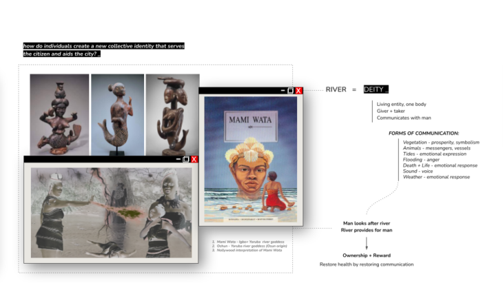
For many tribes the river was a deity, one body, able to give, take and communicate. Most of these forms of communication were actually just signs of a healthy ecological system. We can use this strategy to restore the river by restoring the communication between the man and the river. This is democratic flood risk management, the restoration of the river’s function through the development of the river’s identity by the city and citizens.
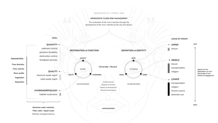
The river must be reestablished as a living entity by creating a unified network that is able to directly display its function, display its development, and reward its participants. The restoration of function can be achieved through the renaturalization of the river. These goals, in a nutshell, aim to maximize water retention, prevent obstruction, and filter waste in order to maintain an hydro ecological balance.
The definition of identity can be achieved through the reculturalization of the citizens. There needs to be a clear medium that will serve as the infrastructure to direct the citizen’s engagements with their water.
Mapping the hydrological processes of the floodway and floodplain
Reconnection of the river means reconnection to the land itself.

A study aimed at understanding a community’s relationship to water led to a precedent for communicating the flows of water. Makoko, a floating village that relies on fishing and lumber, floats their logs in the Lagos Lagoon as a form of storage. Looking at them in plan view, their formations indicate flow direction, velocity and even sedimentation build-up.
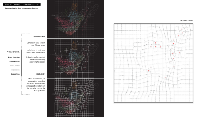
A grid was overlaid on this map of flows and the vector directions were used to morph the grid, contracting the cells where the flows converge. This indicates a convergence of not only water but of sediments, nutrients, solid and chemical waste. These become pressure points, the starting point of intervention towards our goals.

The water flow in the lagoon is quite different from the flow in the linear floodways. Though we are trying to understand pressure in the linear direction, the flows we need to map actually come from the lateral direction. It is the convergence of flows in these two directions that create our pressure points.
The river is essentially the bloodstream of the environment, as it delivers the nutrients and resources necessary for the development of life; flora and fauna. Understanding how this bloodstream is fed and distributed is essentially mapping the convergence and dispersal of water; pressure points and relief points.
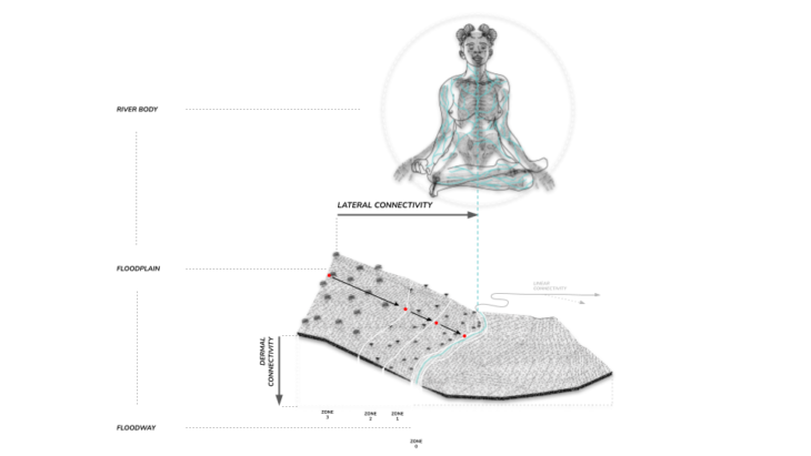
The pressure points are the starting point of intervention towards the location for implementing interventions for the quality, quantity, and hydromorphology goals in an optimal manner.
As water flows through the floodplain, it has to make a decision; to infiltrate or to runoff, to percolate or to be absorbed, retained by soil and vegetation, to move forward into the next zone through interflow or to percolate downwards into the baseflow. Each of these forks in the roads decreases the time it takes for water to reach the floodway in zone 0.

Currently, impermeable surfaces in and around the floodplain have hindered infiltration, thus decreasing percolation, interflow, and baseflow. The water has only one decision to make, to runoff surfaces and converge in the floodway, causing flooding; therefore, surface runoff becomes the major flow we need to map in order to identify our pressure points.
Designing microcatchments
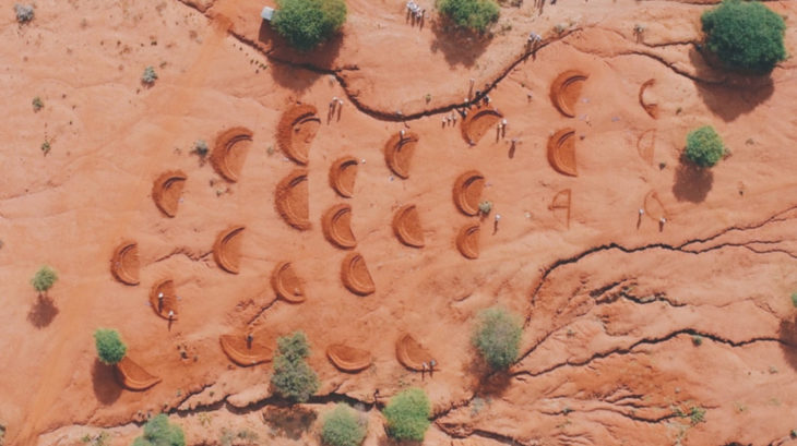
Micro-catchments redirect runoff through surface alterations. Bunds are a type of micro-catchment that optimize surfaces by using coordinated mound formations to direct runoff, allowing water to infiltrate the ground before it reaches the floodway. They dismantle large quantities of water and maximize surface retention quality.
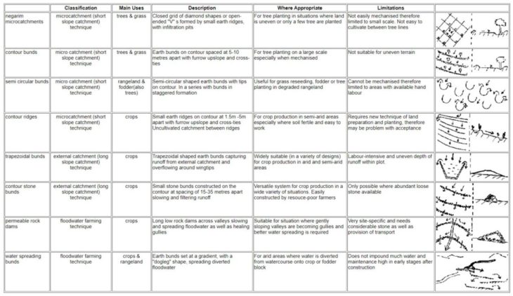
Bunds are composed of small mounds and barriers, surface alterations, that are able to divert surface runoff water coming from other catchments along with precipitation. They do not require heavy specifications that leave a tight margin of error in order to be operable and can be used to divert runoff from areas with high peak runoff rates into areas with low peak runoff rates by simply creating a linear axis from and towards the high and low peak runoff area using the surface mound.
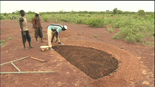
While distribution is achieved through the geometric formation of the bund, retention is achieved through vegetation and ground cover. Vegetation also increases percolation as well as provides another avenue for water to travel, this is through the root system of the plant and eventually through evapotranspiration.
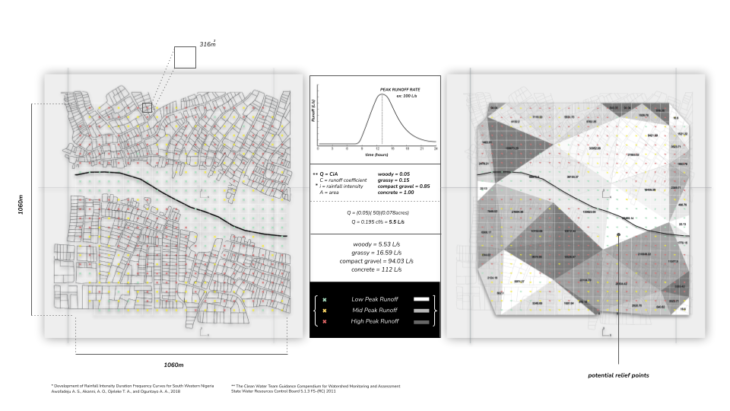
A peak runoff rate essentially tells us how much water is passing through a given plot of land per second. It takes three key factors into account; rainfall intensity, a runoff coefficient, and the area of land. The most important value being the runoff coefficient. These are fixed values given to different types of ground covers from woody to concrete. When we divide our site into plots we can map these rates from low to high peak runoff. To get a better understanding we can further group these plots and map these groups from low to high runoff areas using gradients of grey. The areas around the river, in white, have the lowest peak runoff rates, offering potential relief points.
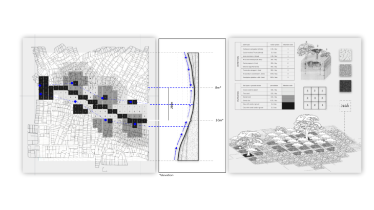
This bund micro-catchment strategy essentially plots a land rehabilitation and flood mitigation scheme. This is the layered information that needs to be decentralized and democratized. It is crucial for this information to be visibly communicated to the community in order for them to carry out and further develop this strategy within their environment.
Application and implementation strategy
How do we communicate these micro-catchment schemes that can maximize retention in heavy inundated areas, disperse and moderate flows in areas with high discharge velocities, create interventions that confront water quality issues before they reach the floodways, and most importantly, engage the community in the restoration of their environment?
This is where the city comes in as a platform of communication. The city has the opportunity to establish a formal language that serves as a guideline from catchment to catchment, using a spatial framework that communicates these schemes and can be populated by each community. Bunds are appropriate for this implementation because they are visually simplistic.
By demarcating pressure and relief regions using bund geometries, the city informs, “this is where water needs to go”, the citizens engage the implementation, and the water follows these directions. This partnership is the restoration and definition of the floodways and floodplains by the city and citizens.
Closing
What if we changed our linear ideas of our impacts, acknowledging that we are an extension of our environment?
We’ll find that as we exercise control that doesn’t try to fight water, but invites it into a meeting place, we create temples for nutrients, flora and fauna that serve beyond the immediate region. As we find our place within this framework in a continuously changing landscape, We collectively build a body that exemplifies a strong social ecological connection between our immediate selves and our extended selves, our environment.

The communities and individuals that will benefit from this strategy are the ones that acknowledge the river, investigate its changes, and participate in the development of its new identity. Giving to the river, will give to the citizens, creating a narrative where function and identity are present not only in the environment, but in the culture.
This is democratic flood risk management. This is the new dialogue between the city, the citizens and their water.
Research Thesis Developed by Eve Nnaji
Thesis Advisors: Mathilde Marengo + Gonzalo Delacámara