W.I.L.D
Wetland dIversity of Luxembourg lanDscape
Abstract
W.i.L.D. aims to visualise the typological diversity of Luxembourg’s wetlands categorized by area and location in the area of Bertrange, as well as in the total area of the country. The project was developed in relation to the Internet of Cities studio and the challenge of Rewilding Luxembourg, which is investigating the strategies to increase the fragmented wetland connectivity in the area of Luxembourg.
Introduction
Wetlands are marshy areas of land where the soil is saturated with water; or where land meets water. They are areas where the presence of water determines of an area’s biogeochemistry; the biological, physical, and chemical characteristics of a particular site. Many wetlands serve as transitional zones between upland and aquatic ecosystems, although others are scattered across the landscape in upland depressions that collect water or in zones where groundwater comes to the surface. There are many different types of wetlands, each determined by its hydrology, water chemistry, soils, and the plant species found there. Wetlands may be characterized as dominated by trees, shrubs, or herbaceous vegetation.
Luxembourg
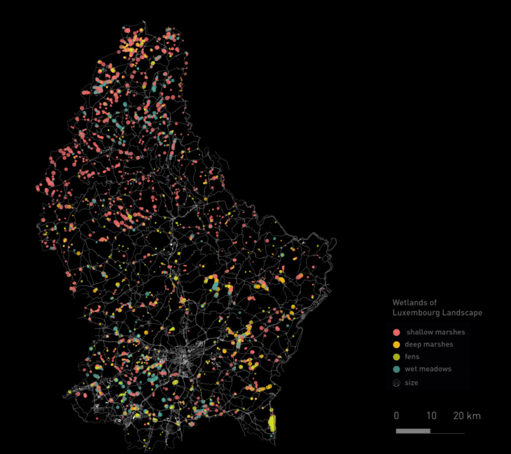
Wetlands of Luxembourg categorized by area and by location | source: Geoportal of the Grand-Duchy of Luxembourg
In Luxembourg, there are 4 types of wetlands: Shallow marshes, Deep Marshes, Wet meadows and Fens across the whole country. Marshes are wetlands that are permanently flooded or flooded during high water periods at the edges of rivers, streams, lakes, or ponds. Wet meadows are wetlands with permanently or near-permanently saturated soils, while fens are wetlands that are fed by groundwater that “seeps” out to the soil’s surface.
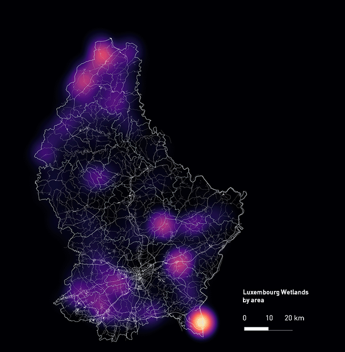
Wetlands of Luxembourg | source: Geoportal of the Grand-Duchy of Luxembourg
Graphs
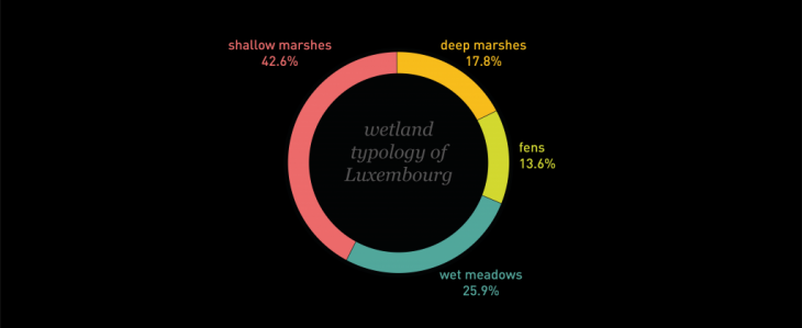
Pie Chart | Wetlands of Bertrange | source: Geoportal of the Grand-Duchy of Luxembourg
These graphs are identifying the typology of wetlands in Luxembourg. On the pie chart above one can see that the biggest part of the wetlands in Luxembourg is Shallow Marshes, which means that are mostly flooded areas during high water rise. On the other hand, the biggest problem of Luxembourg’s wetlands is the fragmentation. During the years and due to the urbanization and the industries, the wetlands are starting to become smaller, which will lead to the destruciton of the wetlands ecosystems. As we can see through the histograms below, all types of wetlands are mostly small in size, validating the problem.
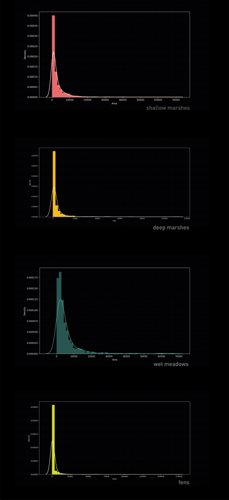
Histograms | Wetlands of Luxembourg | source: Geoportal of the Grand-Duchy of Luxembourg
Bertrange, Luxembourg
Wetlands of Bertrange | source: Geoportal of the Grand-Duchy of Luxembourg
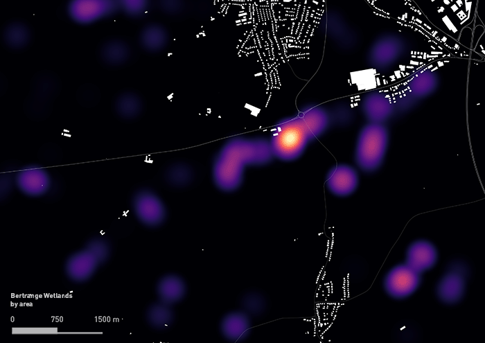
Bertrange is a commune and town in south-western Luxembourg, located 6.5 km west of Luxembourg City. As of 2006, the town of Bertrange has a population of 6,021. During the Internet of Cities studio, this area has been identified as the area of main analysis and intervention regarding the Rewilding Luxembourg challenge. On the south outskirts of Bertrange town, Grouf River creates the existing wetlands as shown in the picture below.
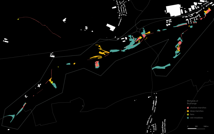
Wetlands of Bertrange | source: Geoportal of the Grand-Duchy of Luxembourg
Graphs
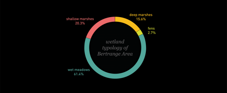
Pie Chart | Wetlands of Bertrange | source: Geoportal of the Grand-Duchy of Luxembourg
These graphs are identifying the typology of wetlands in Bertrange. The biggest area is Wet Meadows, which means that the wetlands are at a big percentage, permanent in the area. However, as we can see in the histograms below, the area of all the types of wetlands is mostly small, which reflects the general problem of wetland fragmentation in Luxembourg.
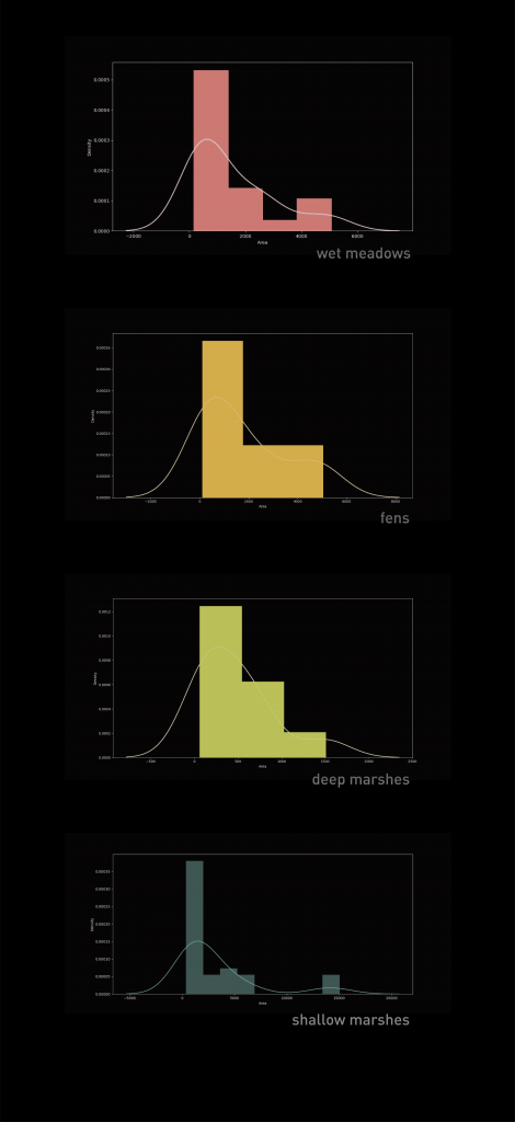
Histograms |
Wetlands of Bertrange | source: Geoportal of the Grand-Duchy of Luxembourg
Conclusions
W.I.L.D started as the initial analysis according the typology of wetlands in Luxembourg and Bertrange. However, using tools such as QGIS and Python for analysis and visualisation, the data collected turn into important information for our project and a strategic tool through the design process.
W.i.L.D is a project of IAAC, Institute of Advanced Architecture of Catalonia developed at Master in City and Technology in 2020/21 by student: Stephania-Maria Kousoula, and faculty: Diego Pajarito