IAAC – Master in Robotics and Advanced Construction
Workshop 2.2
–
Faculty: Sebastian Kay
Faculty: Vincent Huyghe
Faculty: Ardeshir Talaei
MULTISPECTRAL CONGNIFICATION
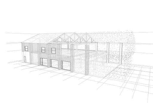
Credits: Adeshir Talei.
Syllabus
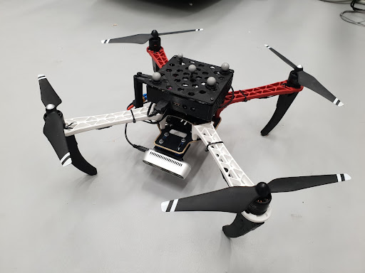
The workshop will explore the implementation and application of autonomous mapping using rovers and drones. The workshop will focus on 4 key topics:
- Autonomous navigation
- Data acquisition strategies
- Data processing and visualisation
- Applications of mapping in the AEC’s industry’s
Autonomous navigation: While continuing to build upon the knowledge the students have acquired during the software 2 class with the ROS navigation stack using rovers. The workshop will introduce the use of ROS navigation stack for use with UAVs.
Data acquisition: Using a multitude of sensors such as Lidar, RGB, RGBD and Radiometric cameras students will have to develop a mapping strategy that is appropriate for the sensors and application.
Data processing and visualisation: Covering both onboard real time processing of the incoming data streams during the autonomous mapping process as well subsequent off board processing of the data. This will hand in hand with exploring ways of visualising, labelling and formatting the data in such a way that it can enable better decision making for AEC professionals.
Applications for AEC industry: Students will be asked to speculate on and develop applications that leverage the opportunities offered by autonomous and multispectral mapping for architecture, engineering and construction industries.
Credits: Sebastian Kay
Learning objectives
At course completion the student will learn:
- ROS navigation stack for rovers and drones.
- Data acquisition and processing tools such as: OpenCV, PCL, Point could assembler