IAAC – Master in Robotics and Advanced Construction
Workshop 2.1
–
Visiting Faculty: Keith Kaseman
Faculty Assistants: Will Reynolds, Daniil Koshelyuk.
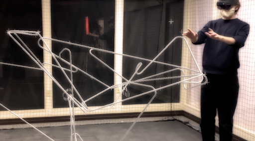
SENSE: IMMERSIVE OPERATIONS
Credits: Spatial Futures Lab | Georgia Tech School of Architecture
Syllabus
REGENERATIVE SPATIAL ARMATURES: 2030+
AI-assisted spatial analytics, mixed reality (MR), spatial tracking, intelligent components, and other sensing technologies continue to proliferate throughout design professions and construction practices. Ultra-localised cooperative design engagement and spatial production can now be readily facilitated through customised workflows that orchestrate real-time interplays between sensed data and immersive interactions. Design activists are rapidly becoming uniquely equipped to initiate and execute architectural actions that combat urgencies of our era through regenerative spatial opportunities embedded within urban fabrics.
This workshop aims to couple spatial data and skill sets acquired thus far in SENSING MACHINES STUDIO with interactive capacities uniquely achievable through mixed reality (MR). Cooperative immersive design approaches will be introduced and configured as design environments through which projective modes of spatial practice and positively strategic architectural action will be imagined, explored, refined, and demonstrated.
In addition to the use of personal phones and tablets to design, navigate, and test augmented reality (AR) applications, participants will have access to multiple Microsoft HoloLens 2 headsets equipped with full Fologram licenses for the duration of this workshop. Rhino 7 (www.rhino3d.com), Grasshopper (www.grasshopper3d.com), and Fologram (www.fologram.com) will be the primary software platforms.
Learning objectives
At course completion the student will be able to:
- Operate cooperatively within an immersive design environment.
- Customise interactive mixed reality (MR) spatial design operations and interfaces.
- Orchestrate manual, semi-automated, and automated data-flows as design tools.
- Interweave sensed, streamed, and spatial data into operable strategies and scenarios.
- Develop and project critically informed future multi-system spatial imaginaries.