This work explores the relationship between the urban mobility infrastructures (as are expressways, sidewalks, etc) and the desirability of paths within the urban realm. In order to do so, we have developed a Weighted Network Model that allowed us to assign value to different variables within specific routes in our network. Throughout this work, we will discuss the variables and methods used to generate our model, as the results of our research.
Introduction
Puerto Rico’s mobility infrastructure was conceived in the height of the 20th century. Its main theoretical structure comes from the planning policies of the post-war era in the USA. The surge of suburban developments, and car-centric transport planning provide the city of San Juan with its current layout. The specific issues that have been identified in the area of study are, for the most part, the product of larger patterns of economic policy, racial injustice and planning strategies that paved the way for large infrastructure projects, as where those developed as part of the City-Renewal initiative.

The Baldorioty de Castro Expressway de-facto segregated the county of Santurce into two different neighborhoods. These neighborhoods are known as Ocean Park (beachfront properties to the north) and Villa Palmeras (historic, working-class neighborhood to the south). This division has further exacerbated patterns of racial and socioeconomic segregation and severely disrupted the accessibility of the neighborhoods to pedestrians and folks with diverse functionalities. The vehicle-centric design of the mobility system within our area of study has physically created barriers, abandoned spaces and a myriad of health and security reasons.
Context: Mobility in the San Juan Metropolitan Region
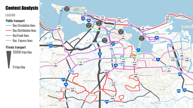
The Baldorioty Expressway is one of the main arteries of the San Juan metropolitan region. The Expressway (identified in the map as Highway-26) helps connect the North-Eastern corridor of the Island of Puerto Rico with the center of economic activity the Capital City of San Juan. Estimates suggest that at least 125,000 cars pass through this stretch of Expressway twice a day.
This video shows the evening rush-hour traffic on the Baldorioty Expressway. The camera is moving from the outskirts of the city towards the center of the city (East-West). On the opposite lanes we may appreciate the level of traffic congestion caused by the volume of vehicles trying to leave the city (West- East).
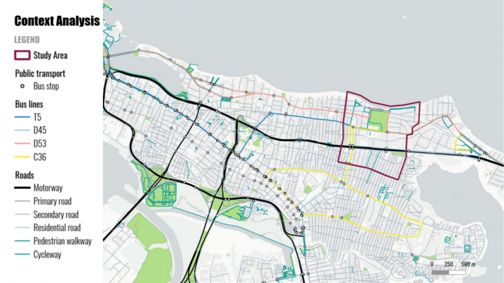
This map presents the mobility infrastructure of the areas that surround this project’s area of study. The large motorway that crosses horizontally on the map is the Baldorioty Expressway. The map also identifies bus stops and their routes.
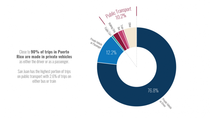
Decades of bad management and under funding of the public transport system in the San Juan metropolitan has left the public transport system in a state of decay. This issue has forced folks to depend, almost exclusively, on private vehicles for transport.
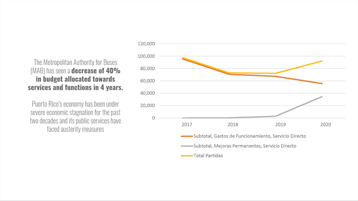
Data from the Metropolitan Bus Authority (MBA) present a bleak picture into its operations. The MBA has faced a 40% decrease in budget allocations over the past 4 years. In 2018, the MBA would suffer from a severe shortage of personnel and equipment due to budget constraints. That being said the MBA still manages to transports around 50 thousand passengers per month.
Context: Socioeconomics and Infrastructure
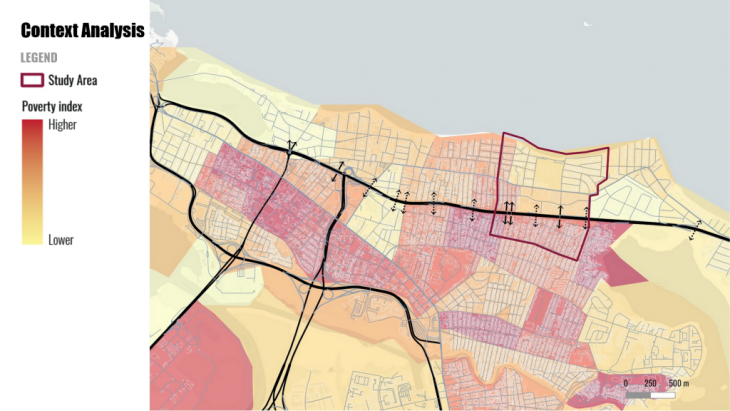
Puerto Rico is a country with a great deal of socioeconomic inequality. The map above depicts a sharp contrast in the spatial concentration of poverty. The inner-city (the areas highlighted in red) is divided from the beachfront properties by the Baldorioty Expressway. As this part of the city evolved throughout the 20th century, the concentration of wealth was further highlighted by the physical segregation of the urban realm. This allowed for the creation of wealthy enclaves in the beachfront neighborhoods which benefited from the physical and cultural distancing that the Expressway created. As we will see throughout this work, the quality and maintenance of the public built environment seems to be correlated with the concentration, and distribution, of poverty.
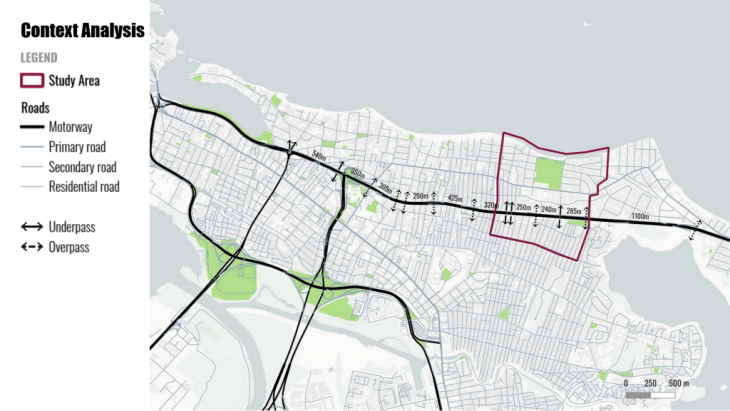
One of the ways the Expressway furthers socioeconomic exclusion is by limiting movement. In the 4.2km of Expressway that are analyzed in this map, there are but 13 crossings, or 1 every 323m. As shown in the next slide, the typology of the crossings vary greatly.
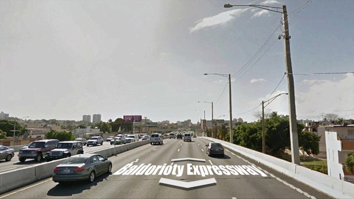
The expressway itself is composed of a semi elevated 8-lane expressway. In the two ground-level crossings, the pedestrian is faced with high-traffic crossings that span 3-4 lanes or overpasses that are in a state of utter decay. Of the negative side effects of the Expressway’s design is its creation of large swaths of land that are mono functional and hostile towards people. The liminal and transitional spaces (being the borders, overpasses and underpasses) are for the most part in a derelict state and are not designed to provide safety nor comfort.
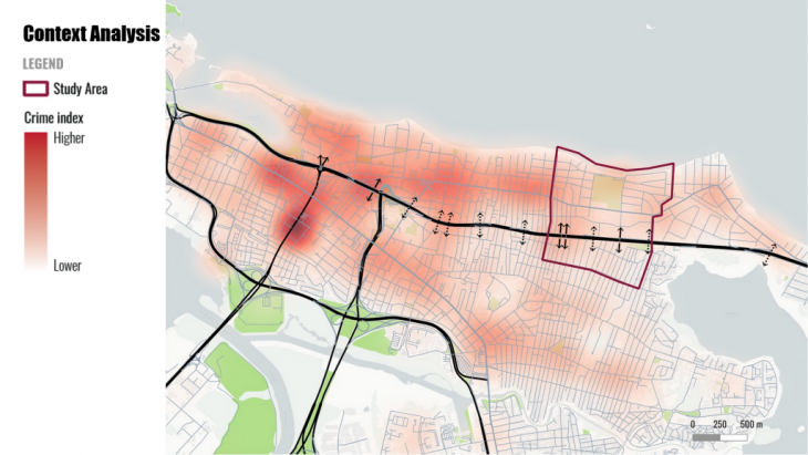
As safety and comfort are important variables when considering a particular route, we have gathered data on the location of crimes in our area. This data will be used to compare and contrast the model we generate.
Methodology and Objectives
The main goal of this work is to create and test a method to provide value to user perception. Understanding how people value different variables is tricky. There is no objective method that would permit the standardization of values. Our response to this issue is to create a method that is based on the user’s subjectivity. This method is based on the numeric valuing of subjective interpretations of space. We have called it the City Graph Tool.
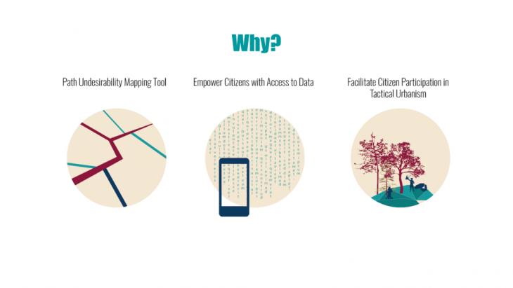
The end objective of this tool is to give users the power to map and communicate information about the experience of passing through specific areas of the built environment. This may open doors to further user participation in the planning and maintenance of urban space.
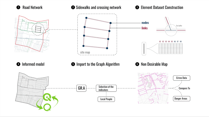
Our work’s methodology is based on 6 steps (or phases). The firs step is to identify or create the Road Network within a GIS environment. The second step is to link the roads (or links) through nodes within the GIS environment. The third step is to generate and organize the attributes (or variables) to be valued and the value system for each one. The fourth step is to then gather values for each attribute on-site using a mobile GIS app. The fifth step is to process the data using the Graph Algorithm. The final step would be to corroborate the output of the Graph Algorithm with field observations and to analyze the output.
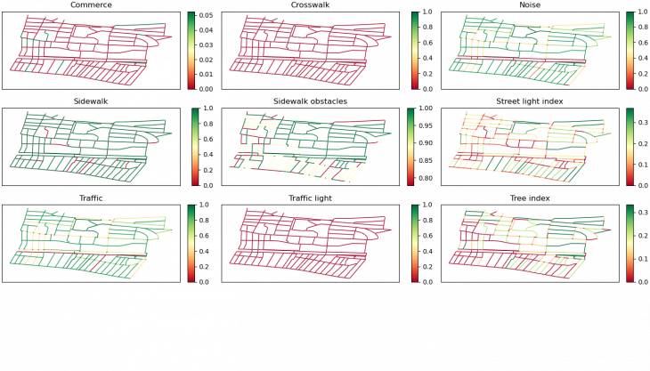
To simulate a road network City Graph use a graph to represents the road network of a city. So each road/sidewalk/path are represented as edges of the graph. And each edges have attributes to represent it.
City users are simulated by agents who choose the best path to go from one node to another of the graph. Attributes of edges have positive or negative impacts on the agent. Each type of agents will not be affected in the same way by attributes. For example the noise from the street could have a very negative impacts on a pedestrian but a limited impacts on a car driver. So the best path is the path who minimize the sum of negative impacts.
Analysis
The final 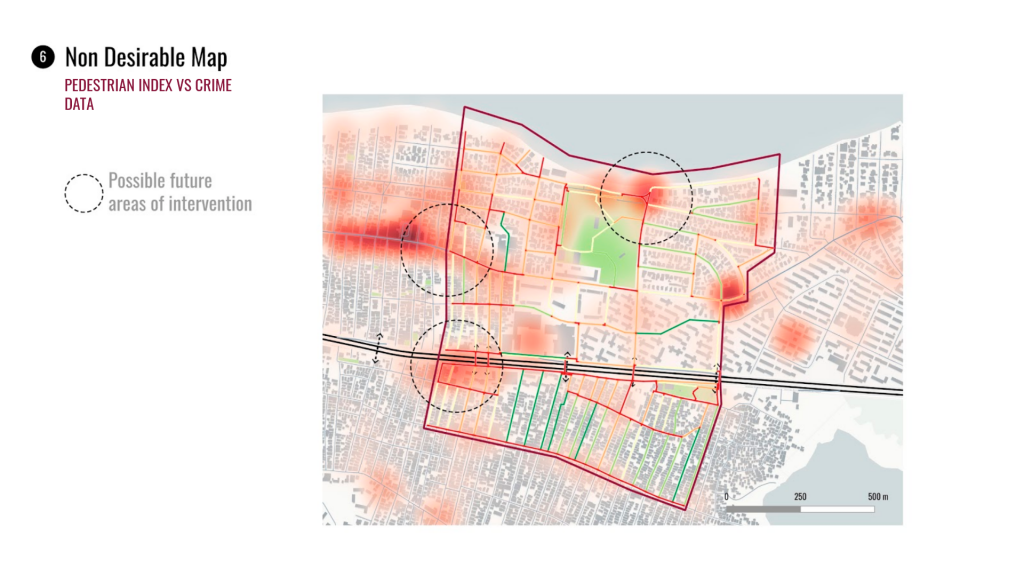
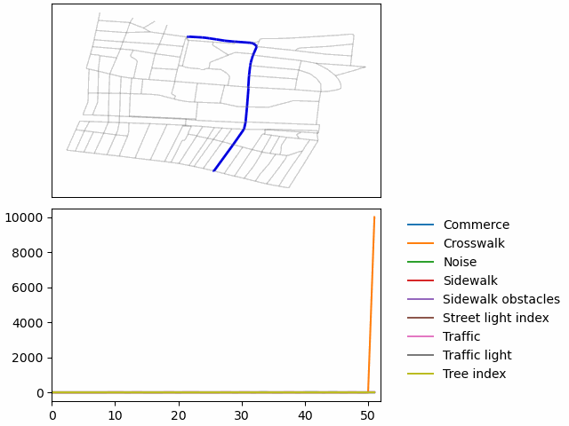
The final output of our work is the graph shown above. The analysis identifies the desirability of paths on a color gradient in which red identifies the least desirable path and green as the most desirable paths. Since the variables we used in this study include things like traffic, street lights and tree cover (amongst others) if we where to isolate any of these variables, we could analyze specific dynamics of the urban environment. As part of this research, one of our objectives was to analyze the relationship between the space in and around the transport infrastructure (the Expressway, roads, sidewalks, etc) and notions of security(insecurity) the City Graph was then overlaid with the crime dateset. Based on the data we’ve gathered, we could establish that there is a correlation between the undesirability of some streets and criminal incidence. That being said, the possible causality of these hot-spots might be more dependent on variables other than mobility and transport per se. The areas that highlight as hot-spots are areas that are either parking lots or streets with intense nightlife. While our approach requires fine tuning, we do believe that, with more time, this method is able to provide profound insights into urban dynamics.
This video follows the most desirable path found by our City Graph tool. The path connects the northern part of the city with the southern part of the city via an almost direct path that passes by the main park of the area and under the expressway.
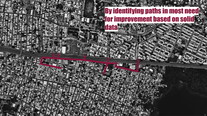
The method we have developed for this project should be understood as a tool for gathering data from the users perspective. It is intended to represent the subjective experience of people within the area of study. In doing so, this tool may provide knowledge on very particular issues within the urban realm and, with a large enough sample, subjective values may become patterns. These patterns, and particular cases, give both citizens and decision makers a tool to compare streets and to justify action.
Undesirable Paths: Analyzing Path Desirability Through Weighted Network Models is a project of IAAC, Institute for Advanced Architecture of Catalonia developed at Master in City & Technology in 2020/21 by students: Alvaro Cerezo, Leyla Saadi, Mario Gonzalez, Inigo Esteban Marina, Tugdual Sarazin and faculty: Francesca Arcuri & Federico Parolotto.