The agency of mapping / Applied Theory I-II-II
Mapping, the process of making a map, extends to several fields and follows several methodologies. With the first instance of a map dating back to prehistoric times, the concept of mapping has evolved into the modern way we perceive maps today in parallel with the evolution of the technology. Architects use maps as a visual reference to an extensive research process. It is an end product gathering layers of information to make sense as a whole. What makes a map relevant is the data collected and the way it is parsed and eventually visualized. Therefore, the notion of the territory and the architectural scale have changed with time because of the tools that are now recording the data to be able to build said maps. For instance, the scale focused on the grandness and wideness of the territory as opposed to its new meaning: the accuracy and depth with which data is collected and parsed. We eventually find ourselves with a whole new methodology of mapping, a new collection of maps – each one more different than the other, and several conjectures concerning their benefits to the construction industry and relevance to be included in the entire process.
This paper focuses on the definition of a map, the evolution of the tools used in the mapping process and the relevance and benefits of the implementation of these maps in the construction process. We carried out our own experiment that focused on establishing several criteria to evaluate several maps to then be able to break down the reasoning behind the methodology used to build them. By doing so, we were able to derive several conclusions concerning the relevance of these maps in the industry.
The following question then arises: What are the new possibilities that emerged from the advancements in mapping technology?
The definition of Mapping
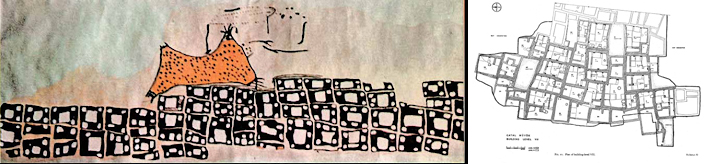
~6000 BCE , Catal Huyuk, Wall Mural, unknown author / 1964, Catal Huyuk, Wall Level 6 Plan
The concept of mapping is one that is used in different aspects, times and professions. Inorder for us to lay the basis of our discussion – The potential of mapping to the AEC industry in the age of the 5th industrial revolution, we have to comprise a definition of what is a map and what are its properties.
Evaluation Criteria
We studied several maps and created a list of criteria that would allow us to conduct another round of analysis, this time focusing on each aspect in the following diagram:
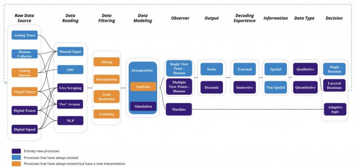
Evaluation Criteria
All maps were analyzed according to the source of the data, its representation and interpretation, the type of observer and the type of action that they generate. Doing so has helped us not only structure the analysis but derive conclusions on the methodology in question and the general concept of mapping thus far.
Conjectures
We were able to come to three conclusions regarding the agency of mapping and the new maps we are seeing more and more of today.
1. Derived Actions
First, the map generates what we refer to as a derived action regarding the type of action it generates after its analysis. What is the objective of this map? Under this category, the map could incite one of three things:
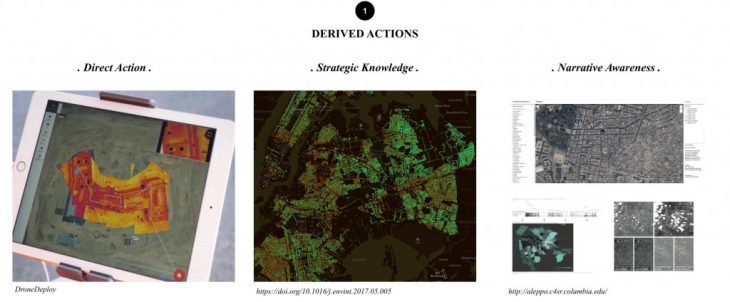
Derived Actions
- A direct action: a decision that is made after the map is in the hands of the stakeholders.
- Strategic knowledge: the map simply sheds light on a topic or informs the user / observer on the current situation.
- Narrative awareness: the map creates a collective whole where users can understand past, present and future instances of the issue mapped.
2. Observer’s Involvement
Another conclusion lies in the relationship of the observer with the map, its interaction with the data.
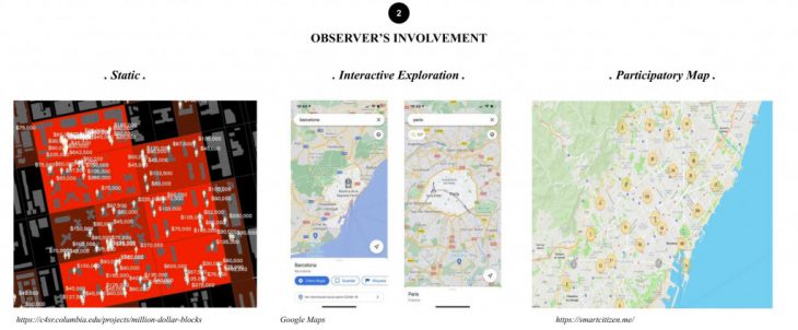
Observer’s Involvement
The Static state represents the data that exists, that is analyzed and that generates an action: in other words, a static map. The Interactive Exploration is the data that is fixed but its analysis and behavior is dynamic: the map is related to the observer. The Participatory Map, the most complex and dynamic form, is generated by existing data and relies on open source and real time contributions by users. Not only is it interactive like in the previous case, but the user also plays an active role in generating it and in the action it eventually generates.
3. The Visualization
Finally, the Visualization considers the time variable in the data.
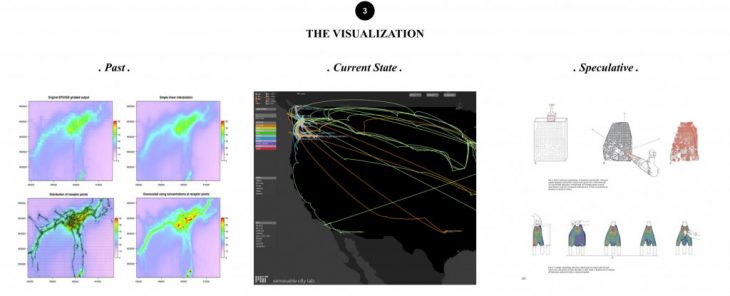
The Visualization
Through the Past, we understand the accumulation of data that generated a map. The Current State considers the analysis of the existing and real time data to generate an action. The Speculative node refers to the future data brought to the present in order to anticipate conclusions or behaviors. It considers existing behaviors to draw conclusions, but uses real-time and future data for its analysis.
Comparisons and eventual conclusions
With a clear categorization, the maps we studied were compared on a 9 by 9 three dimensional grid in order to obtain trends and behaviors of the maps in the AEC industry.

The maps of maps
1. The color codes helped us find the most concentrated areas of the graph, which lead us to raise the following three points:Participatory Mapping, although growing in more recent projects, seems to be a vacant niche that might be used in communicating between the different agents in the industry. Our conjecture is that these types of mappings are more related to Data Transparency, and its protocols. As a direct communication tool, we assume it will be beneficial to the entire construction industry.
2. The speculative tools are more related to the design phase, and are therefore used in specific professions like structural engineers, urban developers and environmental engineers and financial agents.
3. We see a growth in the cross section between the interactive exploration, current state and strategic knowledge. We project that these kinds of projects can be utilized in such sectors that wish to deal with project failures, such as logistics and Management level.
We invite you to read the full paper in the following links:
The agency of mapping // Applied Theory I-II-II is a project of IAAC, Institute for Advanced Architecture of Catalonia
developed at the Master in Robotics and Advanced Construction in 2021 by:
Students: Shahar Abelson, Alberto Browne and Helena Homsi
Faculty: Mathilde Marengo