TERRA: Landscape Web App
Convert, Create and Analyze Landscape
Terra is a web app for students or landscapers who aim to understand or study an specific territory. You can convert, create and analyze all the terrains you want from a heightmap image. We have used the plugin Bison to obtain quick and easy analyze landscape results.
Web App Tools
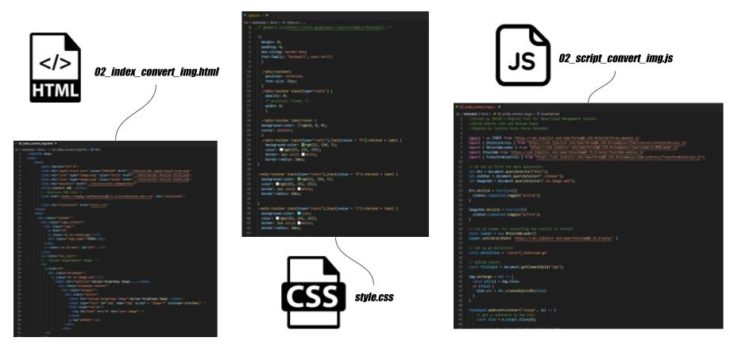
We developed Terra with diferent web tools:
- HTML: to define input and output parameters that we will need for our web,
- JAVASCRIPT: we will create the actions and process our web will compute or define, its our main brain in some way,
- CSS: styling it to have a fancy and coherent design.
- Rhino Compute: To compute grasshopper files inside the web app
Web App Workflow Use
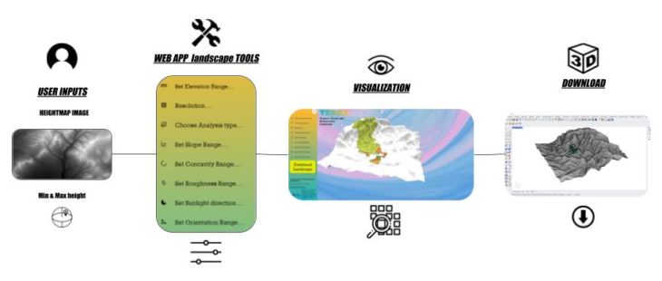
How to use Terra?:
- Download heightmap .jpg of the site you are interesting on from the web:
https://tangrams.github.io/heightmapper/
- Go to Terra Web App:
https://bimsc22-landscapetest.herokuapp.com/examples/terra/02_index_convert_img.html#
- Upload Heightmap Image: Take the image you downloaded and upload it.
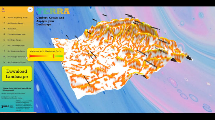
- Set Elevation Range: You should write the maximum and minimum height your heightmap has. You can see this information when you downloaded it tangram or you can invent it.
- Resolution: If you dont want to detail information or it goes slow, set the resolution you want, the bigger the lest detail the landscape terrain.
- Choose Analyze Type (choose from below which type of analyze you want to know and to visualize):
- Terrain
- Slope
- Concavity
- Elevation
- Roughness
- Shade
- Orientation
- Viewshed
- Watershed
- Optimize Location
- Set Slope Range: When we choose the analyze type “Slope” we can set the degrees that we are interested in investigating.
- Set Concavity Range: When we choose the analyze type “Concavity” we can set the percentage that we are interested in investigating.
- Set Roughness Range: When we choose the analyze type “Roughness” we can set the percentage that we are interested in investigating.
- Set Sunlight Direction: When we choose the analyze type “Shade” we can set the vector of the sunlight to know how is the shadeness.
- Set Orientation Range: When we choose the analyze type “Orientation” we can set the percetage that we are interested in investigating.
- For “Terrain” and “Elevation” we only can visualize it.
- For “Viewshed” and “Watershed” we can move the point we have so that we can investigate specific and diferent locations over the terrain.
- The text number bars that appears tells us the 10 highest and the 10 lowest data we have for that type of analyze.
- Finally the “Optimize Location“: if you set the ranges that we talked before thinking on where to locate your project, this type will tell you where are the best places to settle it.
- You can download all the landscape visualizations as 3D meshes and curves.
Video explaining the web app functions:
</p>
TERRA: Landscape Web App is a project of IAAC, Institute for Advanced Architecture of Catalonia developed in the Master of Advanced Computation in Architecture and Design 2021/22 by Students: Jacinto Moros Faculty: David Andres Leon and Hesham Shawqy