Introduction :
Placa Catalunya, the famous square in the heart of Barcelona is practically the city center. One would find the square to be filled with tourists and locals whether it be a weekday or weekend. With the growing number of retail, cafes, bars and tourist attractions in the vicinity of the Placa, the square itself has become limited in terms of its physical space. It may be time already to turn the square into a block.
The Placa Catalunya has a duality in the way it functions. In plan, it behaves as a central space that connects four intersections. The use of the two axes is extremely dominant. In section as we come closer to the ground level of how the spatial experience is, we find that the sense of the diagonals is very weak, if not non-existent. To understand this disparity, we first tried to understand the Placa historically and how its design changed since its inception. When first designed and implemented in the early 1900’s the landscaping was chunked into four triangles resulting in two clear diagonal paths running through and intersecting at the center. The original design remained in the same arrangement till 1924. Construction was carried out to add green spaces and sculptures. Further additions made in the 1950s were the central pavement and the two fountains on the southern edge. These additions over time started to weaken the sense of the diagonals.
Site & Pedestrian Analysis :
Macro Urban Analysis of Barcelona
Forwarding to the state of the Placa today, we find it to be flanked by primary streets on the north-south edges. Streets on all four sides are also used by local and tourist buses, for which the Placa also hosts a number of information booths scattered at its perimeter. In a Catchment radius of 500m from Placa Catalunya, there are 4 metro stops connecting to L1, L2, L3, L4 lines. n the microanalysis of the place there is 7 bus stops surrounding the periphery.
Through traffic analysis conducted on weekdays and weekends, it was found that the most traffic always showed on the eastern side of the plaza. Here the street has an island at the center which functions as a bus stop for travelers going to the airport. Hence the street is mostly used for queuing by the airport buses and taxis. Cycle stands are placed on three sides of the plaza and only the northern edge has the access point for the metro station below the ground. The FOS (Fruin Level of Service) was calculated for the queuing at the four corners of the site. This calculation aided in understanding which parts of the site were busier than others.
Traffic Analysis, Level of Service & Pedestrian flow Analysis
Issues & Observation :
The analysis of the existing plaza resulted in the identification of three issues. The first issue is the stationary vehicles creating permanent traffic adjacent to the site. Secondly, the exits from the metro stations all face away from the plaza and not towards it. Hence the plaza does not come into the visibility of the commuters. Thirdly, as the crossings are not directed at the plaza from where the metro exists, one would be required to cross the street twice to arrive at the plaza. This has resulted in the plaza becoming an “isolated island”.
Issues & Opportunities
Mitigation Plan :
Conceptual mapping of Paths and movement
In our proposal to transform the plaza into a larger block, the two streets on the east and west side are to become pedestrian-only. To accommodate this change, we reallocated all the services and changed the mobility locations. The northern edge would be used by the tourist buses, the southern edge would make room for the taxi stands serving the shoppers and tourists. The street between the two blocks on the west side has access to the underground parking in its existing condition. This would be used as access for the airport buses as well since the existing parking remains greatly unoccupied. The exit path would also use the existing path from the northeast corner. The bicycle stands would be placed on the northwest and southeast corners. A smooth transportation network would be ensured.
In the existing condition when coming from La Ramblas the crossing is situated away from the plaza along with the wider footpath. The parallel path has the Aerobus stands in the middle creating a divide between the plaza and the sidewalks. Hence when people are using these routes they are farther away from the plaza and it may not even be visible to them. Whereas in the new proposed path, pedestrians are in closer proximity to the plaza, even if they are just using the block to cross and not arrive at the Placa.
Visbility Analysis of Existing & Proposed
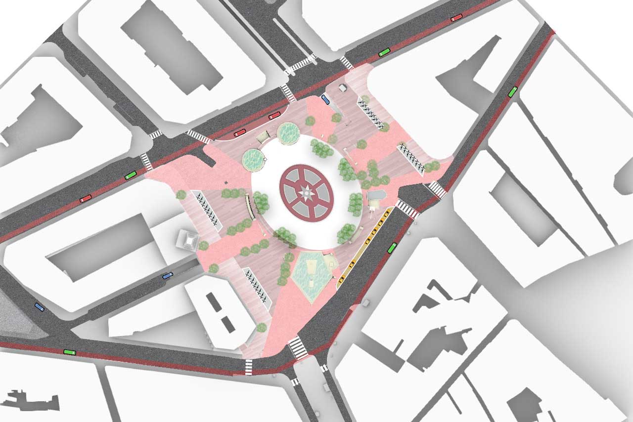
Final Plan for Placa Catalunya: reclaiming urban space for people
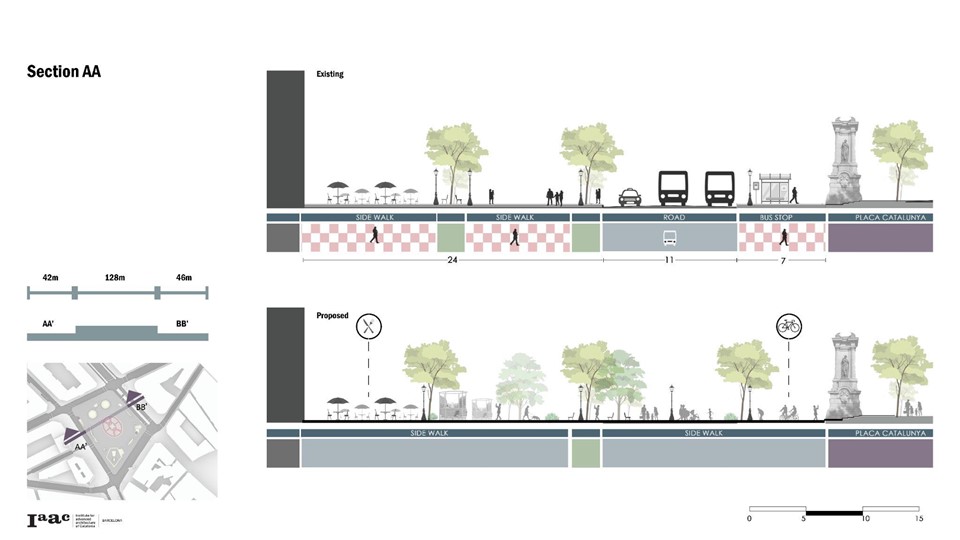
Section 1 – Existing & Proposed
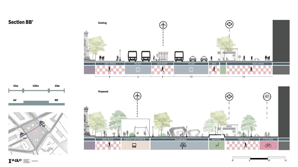
Section 2 – Existing & Proposed
Final Axonometric for Placa Catalunya: reclaiming urban space for people
The goal of this block is for pedestrians to use the plaza, become a part of it, walk through it, see it without even realizing it. They do not have to arrive at it as a destination, but it will become a part of their journey.
Square to Block: Placa Catalunya is a project of IaaC, Institute for Advanced Architecture of Catalonia developed at Master in City and Technology, in 2021/2022 by:
Students: Aida Hassan, Jiyun Lee, Kishwerniha Buhari, Kriti Nirmal & Maria Magkavali
Faculty: Federico Marcantognini, Francesca Arcuri