INTRODUCTION
Junctions, as huge constructions, are becoming obsolete. When this obsolescence is analyzed by considering the scale, it changes based on its context and therefore requires site-specific and a deeper analysis.
By taking this situation into account, in the analysis of Besos River and the huge junction nearby, first, the usage, service and physical conditions of this construction have been reviewed. Considering the main purpose of the analysis, the problematic aspects of the infrastructure were emphasized, and the analysis has been concluded by emphasizing the problematic issues at a local scale.
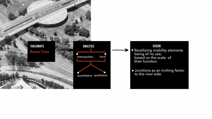
Analysis methodology
ANALYSIS OF METROPOLITAN INFRASTRUCTURE
Moscow is a clear example of a monocentric urban morphology, where both the transport network and land use distribution are concentrated in the central part of the city, which is the main point of attraction. Moscow has with a small number of inhabitants in the central part of the city, while the so-called “donut”, the outer ring, contains the vast majority of the city’s inhabitants. This demographic distribution creates a strong commuting pattern, which puts enormous pressure on the transport infrastructure. In recent years, there has been a trend towards speed reduction on both major roads and ring roads, but speed limits are still high. The radial axis system and orbital routes are reflected in both the road structure and public transport. This type of structure was created under the assumption that all mobility demand is concentrated towards the city centre. Such a configuration clearly affects the traffic flow; the limited availability of roads cannot allow proper vehicle circulation.

Population density and speed analysis
SITE ANALYSIS
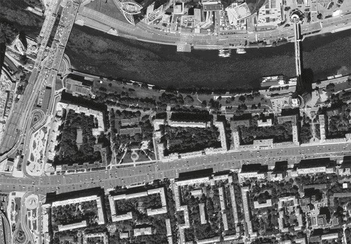
The studied site is located at the intersection of the third transport ring road and Kutuzovsky Avenue. It is a rather problematic area that contains one of the largest intersections in Moscow. The most important thing about it is that it has always been wide and there were a lot of cars even in the 70s. With the growing number of people owning private cars, it is getting more and more used. The traffic density in Kutuzovsky Avenue is also very high because 5 metro lines, Urbun metro and other types of public transport meet there. This kind of huge car infrastructure is becoming more and more obsolete and does not meet the needs of citizens, but serves as a barrier to the transition from one part of the city to another.
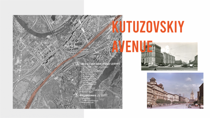
History of Kutuzovskiy Avenue
VELOCITY ISSUE
A viable path to sustainable cities is defined by the need to reduce car space or introduce other appropriate measures for vehicles to enter the city centre. The current situation with Kutuzovskiy Avenue contains an enormous amount of lanes, fourteen in the widest part, forcing drivers to speed up, and the speed limit on the entire avenue is 80 km/h. But what if we reduced the number of lanes from 14 to 9 in the part of the avenue from Minskaya Street to the Garden Ring. And from 9 to 6 at the junction itself. What will that bring us?
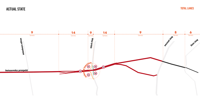
Actual state and proposal for number of lanes
So we can introduce an appropriate speed limit and also add green islands to the avenue, which should calm the traffic and make the surrounding area more friendly and accessible. As a result, we can get a new image of Kutuzovskiu Avenue. It can be an example that this type of strategies can be extended and applied to the same type of streets all over Moscow.
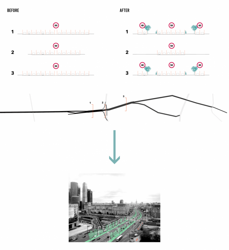
Actual state and proposal for speed and vision
ACCESS TO MOSKVA RIVER
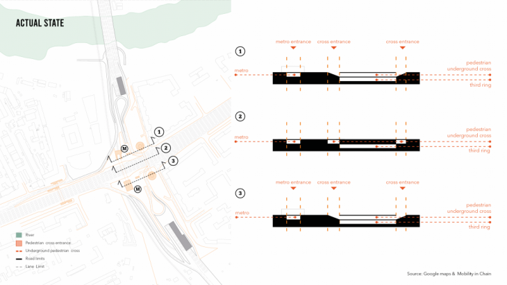
Another problem that this junction represents is cutting the access to the river for the citizens. Kutuzovsky Avenue and junction itself are located near the Moskva River, and the neighbourhoods between the avenue and the railways are segregated from this significant part of the city tissue. Distribution of pedestrian crossings on the right side of the junction and we can see that the only way to reach the other side of Kutuzovsky Avenue is through underpasses, which are not accessible to every group of citizens, such as people with limited mobility. Thus, it creates a situation where the neighbourhood is cut off from the river.
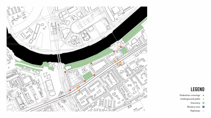
Accesibility to Moskva River
Distribution of pedestrian crossings on the right side of the junction and we can see that the only way to reach the other side of Kutuzovsky Avenue is through underpasses, which are not accessible to every group of citizens, such as people with limited mobility. Thus, it creates a situation where the neighbourhood is cut off from the river. The main goal is to create access to the river by redesigning the junction between Kutusovsky prospekt, the transportation hub and the third ring road.
Pedestrian accesibility to Moskva River
JUNCTION GEOMETRY
The junction we wanted to improve was the one between Kutuzovsky Avenue and the Third Ring road of Moscow. This junction is characterized by its complicated geometry that absorbs a lot of public space and creates barriers between it.

Selected junction: Kutuzovskiy Avenue & Third ring road
-
Analysis of car infrastructure
The speed of the intersection was analyzed. For the entrance to the third ring road, the speed is between and 30 km/h due to the small radiuses created for this ring road, as we can see, 17m and 24m respectively. By taking into account the changes in the section along Kutusovsky Avenue and by the inputs from the radius analysis, we have come to the conclusion that the entrances to the junction could changed.
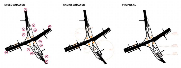
Radius, speed and proposal
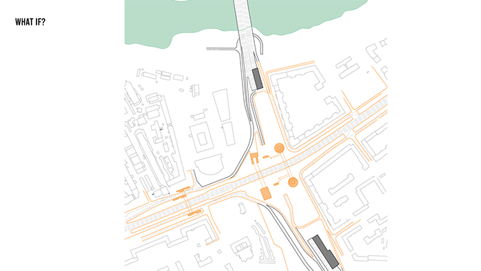
By reformulating the road network, we optimized its spatial need and propose a large public space that covers the junction. This public space is a new opportunity for transportation hub and the city itself.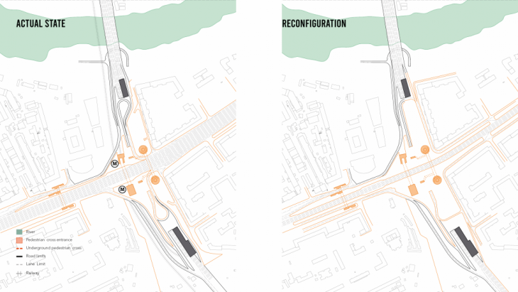
-
Analysis of pedestrian movement
On the other hand, the Kutuzovsky Prospekt underground crossings are also a big issue. Both are full of architectural barriers such as stairs and corners and create a high sense of insecurity when crossing them.
In analyzing the section of the intersection between Third Ring Road, the subway, and Kutuzovsky Prospekt, we found that Third Ring Road runs below the crosswalks. We considered this an opportunity to explore new ways to restore the underground culture, which is considered something negative by Moscow citizens. high sense of insecurity when crossing them.
A NEW PUBLIC SPACE FOR THE CITY
- A new viewport for the city: With all this new empty space, there was a new opportunity to create a new view gateway forthe riverfront by using the roof of the Third Ring Road tunnel and connecting it for pedestrians with a inclined plan with a 3% grade and creating a direct connection to the waterfront. This new visual relationship would be a new way for citizens to reconnect with the riverfront that the city is struggling to find these days.
- Going underground: We decided on an underground square as an entrance for the major transportation hub of this area, also as a way to cross safely, without unsafe corners. In this sense, the square would reconvert the idea of underground culture into something positive for citizens. This depression in the public space also provides environmental protection from the harsh climatic conditions of Moscow, such as wind from the river, cold and snow from the ceiling, which Kutuzovsky Avenue would create. This would allow a continuous flow of people from one side to the other and as a permeable metro station. With ramps and stairs we could connect the entrance in both levels to create a public space without architectural barriers. And the configuration of the space would allow crossing in the surface and direct people to the viewport.
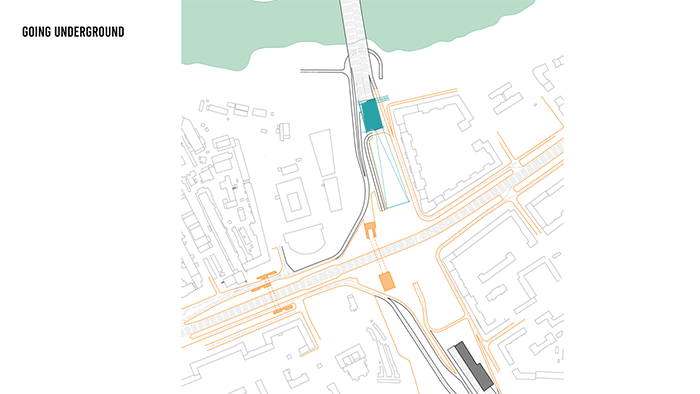 In the end, we would have a continuous 3 level square in section that better understands the potential of the section in the city.
Road Junctions: a new entrance to the Moskva river is a project of IAAC, Institute for Advanced Architecture of Catalonia developed at Master in City & Technology in 2020/21 by students: Adriana Aguirre Such, Arina Novikova, Aishath Nadh Ha Naseer, Sinay Coskun and faculty: Francesca Arcuri & Federico Parolotto.
