“For humans, the need to connect is anthropogenic, We are conditioned to connect both in the physical and digital space.”
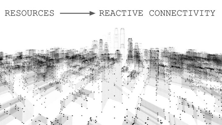
1995 was the year of the internet boom. 2007 is the year the iPhone was created. These innovations have been massively influential to how we behave for those who yearned to connect. And by nature, we adapted to these innovations. But only within those territories that had the resources for citizens to connect.
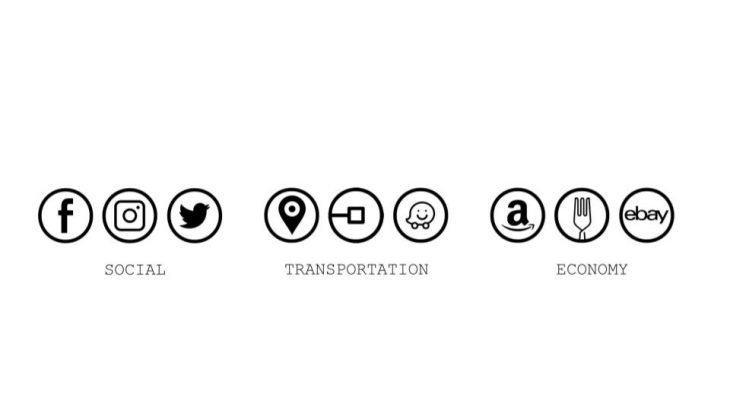 Socially, companies are designing the ways of which we socially connect in both the digital and physical space. Transportation applications create ride-sharing systems between the citizen and the driver, changing the way our cities think about mobility. Economically citizens review businesses and deliver goods to their door, changing the way companies operate.
Education and government systems leverage connectivity in order to improve operations. Online research databases allow researchers to share information faster than ever. All of these organizational constructs must be developed with a cautious approach on privacy and consent from the citizen.
But what about proactive connectivity? Meaning, instead of our users adapting to the resourceful capitalistic territory, how SHOULD we build out connectivity n an isolated off-grid territory? This is how we built our protocol.
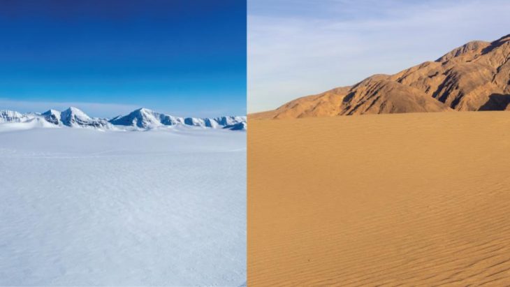
So let’s go to Antarctica and Niger. Two off-grid territories with completely different profiles.
 Antarctica where is the continent of ice is a scientific habitat. Where scientists migrate, usually seasonally, in order to collect a heap amount of useful data for different purposes.
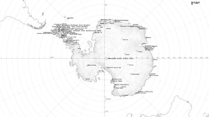
USERS “ Data is the natural resource of Antarctica”. Scientists have taken advantage of: good conditions for astronomy, historical atmospheric conditions entrapped in ice, and the melting of sea ice – to collect data. This data is sent back to companies and governments.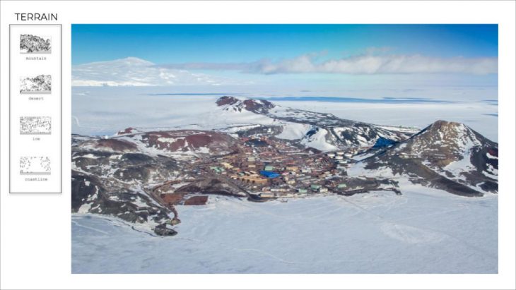 Terrain : our first input of our connectivity protocol
How do we actually connect?
Usually we connect continents via underwater fiber optic cables, but due to the icy conditions, this is not possible. Connectivity starts with an orbit. Since Antarctica is located in the southern tip of the globe, there aren’t many satellite constellations that are visible to the continent. Iridium is a satellite constellation which is visible 24 hours of the day, but provides very low quality connectivity due to bandwidth. There are also highly elliptical satellite constellations, which offer high data rates but are only visible to the territory for around 12 hours a day.
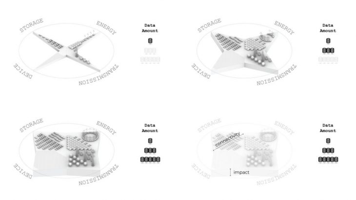
So we can see, over the course of 24 hours, we have No Data, Low Data, and High Data zones from the satellite constellations.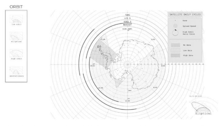
Orbit : Protocol that control time and ability to connect
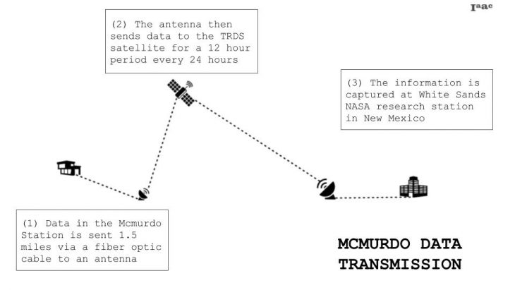
How do we send/receive this data to the orbit?
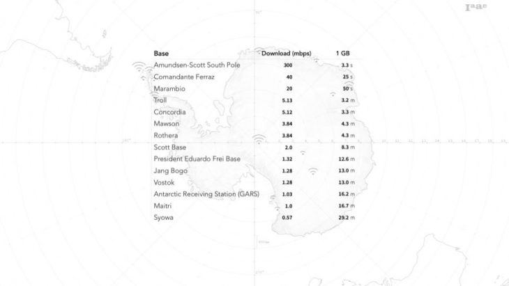
 The connectivity restrictions on the territory currently create less-optimal data rates. It often takes minutes to send 1 GB file around the world.
We’ve now gathered the components necessary to connect Antarctica. Lets group them by existing geographical conditions, and implementable hardware infrastructure.
Each layer relates to its’ neighbors by a ratio.
For example, one solar farm can power 100 computers which is used by 200 people.
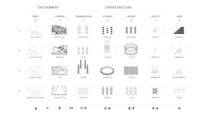
We symbolize them, These together, are all required to create a node of connectivity.

Protocol is used in Antarctica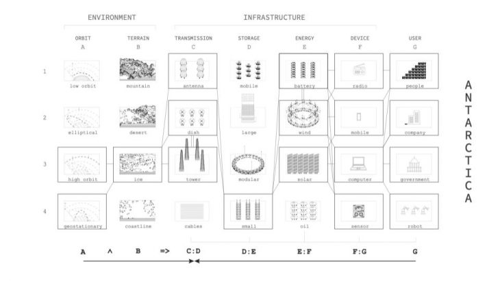
Data collection is the goal of this protocol, the amount of infrastructure needed relies on the data needs of the location in question that means the more infrastructure, the more connectivity.

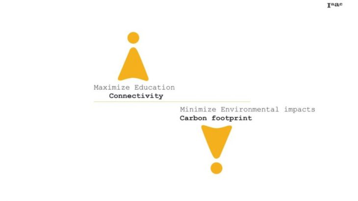
The goal for the project is maximize education connectivity while minimize environmental impacts.
How can we extract the connectivity protocol ?
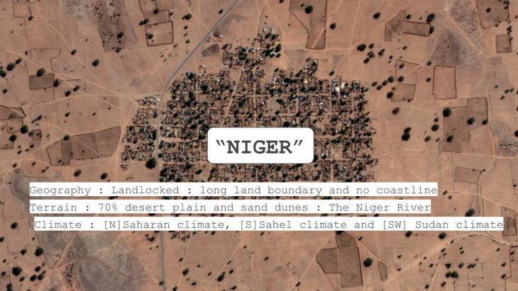
Niger is selected territory that similar to Antarctica in term of physical accessibility and they need connectivity to improve their quality of life.
We know well for Saharan desert and Niger is a country there so it is landlocked country where no coastline, shortage of infrastructure as electricity and water.
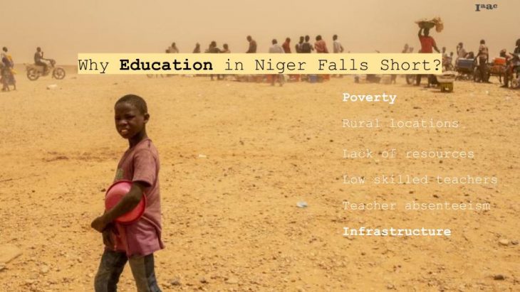
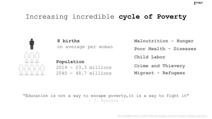
The main problem of Africa country is the lack of education, it caused the circle of poverty. If we can solve the problem of education by connectivity, it can help many countries where faced to the same conditions.
How much connectivity in Niger?
Comparing the internet using around the world, Africa has the lowest connectivity and 10% of population in Niger can connect the internet so If we want to connect for education, the number of out of school kid in Niger is the highest in African.
Are they limited to grow?
If we look at the geography of Niger, it is long distance connection between each city. It affects to the worth of the investment of infrastructure, consequently they need some technology to optimize the productivity such as smart grid system.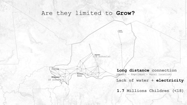
How can we change from the hope to the good future and escape for the cycle of poverty?
Circle of poverty as we know well that cause from lack of education and resource, the way we can solve this problem is increasing infrastructure, expand school by using technology such as smart grid to optimize renewable energy production and it can reduce the investment of infrastructure.
We can see the relationship between energy production and connectivity can affect to the education’s development. If we think of education, it’s not only expanding school will solve all problems, what about adult who can’t read and write or farmer so we think, strategy should cover to everyone such as using mobile for individual learning material and build social network for training skill such as agriculture.
How can we use protocol for Niger?
From the research, the difficult condition of geography such as located in rural area. long distance connection in each city so the goal of protocol is using less infrastructure but expand connectivity as much as possible. The methodology to develop the protocol concern the distance and cellular tower is the answer for Niger that can maximize the signal to 70 km, then another part of protocol has designed following the requirement of cellular tower.
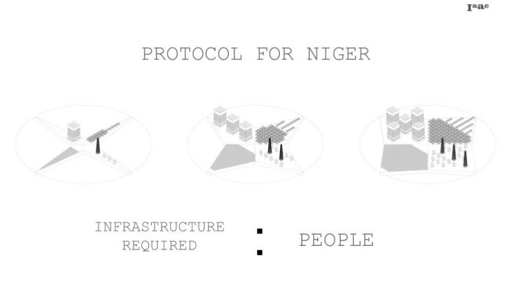
The area that need connectivity to set up schools in each city in Niger.
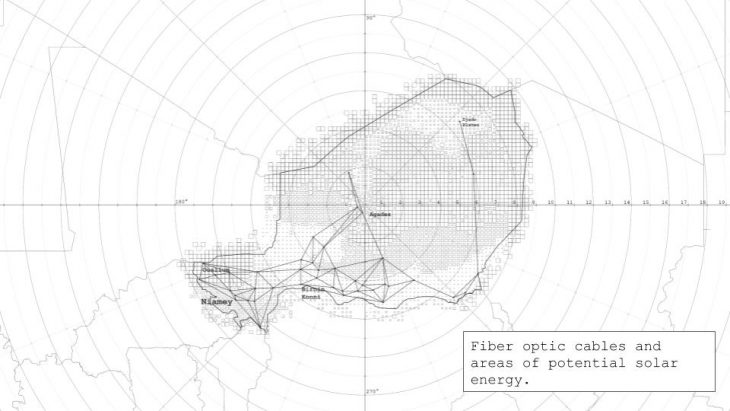
Long distance connection require the fiber optic cables to connect.

The larger the square, the more deserted. Connectivity is less required in these areas So we begin with the more populated areas. Again, each symbol is a NODE OF CONNECTIVITY.
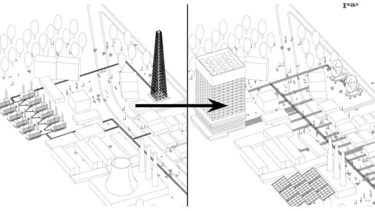
The goal is to replace non-renewable energy sources with renewable ones, while increasing connectivity.
Proactive Connectivity is a project of IaaC, Institute for Advanced Architecture of Catalonia
developed at Master in City & Technology in (2019/2020) by:
Students: Pawitra Bureerak, Eli Munn, Rashid Gilfanov, Andrew Saltzman
Faculties: Mathilde Marengo, Edouard Cabay