Master in City & Technology 2020/21 – Term II
Seminar Name: Digital Tools & Big Data II – Turning big data sets into meaningful information
Total Hours: 20 hours
Faculty: Diego Pajarito
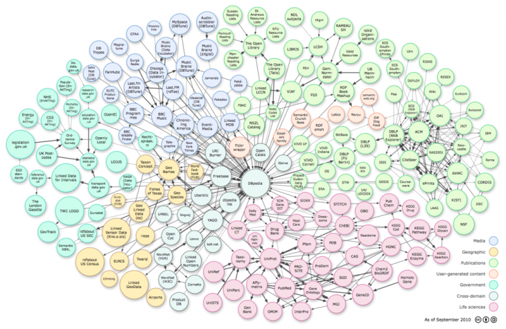
Linked data representation. From: Wikipedia
Course Abstract
Data is not a set of isolated resources anymore. Multiple alternatives exist to allow scientists and urban designers to link information and city dynamics. These scientists have also developed techniques to store, explore and link different types of data. This second part of the course on digital tools and big data aims to explore a wide range of techniques that allow feeding the analysis and design tasks of advanced architecture with data coming from either traditional or non-traditional sources.
The course starts with a comparison between traditional and non-traditional data sources. Due to the strong foundations of the internet, the course focuses on the way an urban designer might look into the vast data sources available when it comes to feature extraction for the urban space. Among other techniques, web scraping is presented as a tool to extract information from websites and platforms while feeding analysis tasks.
After, students will continue with practical sessions for advanced spatial analysis in which they will combine data coming from satellite images and advanced techniques for site selection. The multiple dimensions available in current datasets enables, at the same time, expanded multicriteria analyses that integrate spatial and non-spatial conditions.
The course dives into the communication needs for data science. Students will get in touch with the customisable tools for data-driven multimedia, dashboards and web applications. To enable communication not only within experts but also with communities, the students with the use story maps to assemble geospatial information inside the flow of internet applications.
The course will continue the path of interaction between data science and advanced architecture offering concepts and applications as well as the foundations for the research activities carried on by students for the Master in City and Technology.
Faculty
Diego Pajarito got his PhD in Geoinformatics as part of a Marie Curie ITN Action – Joint doctorate between the Universities of Münster, Universitat Jaume I and Universidade Nova de Lisboa (2018), and the MSc in Information and Communication Sciences from Universidad Distrital de Bogotá (2014). He has performed research for the spatio-temporal analysis of sustainable transport and other urban systems as well as for data collection techniques through mobile devices and crowdsourced data collection. Diego’s interests are the simplification of data collection and analysis for non-expert audiences when it comes to considering it within a geographical context. He has been a lecturer of courses on spatial analysis, big data and spatial databases in Colombia, Universidad Distrital (2010-2015) and Universidad Autonoma de Bucaramanga (2014). He has also been a consultant for geospatial analysis and high-performance computing for different agencies in Colombia such as the Ministry of Agriculture (2010-2015), Institute of Environmental, meteorological affairs (2010, 2012, 2014), Ministry of Justice (2014), Geographical Institute (2007-2010), among others. Daniel is the “Data Scientist” of IAAC’s Advanced Architecture Group and seminar faculty of the MaCT.
