Lower Llobregat: Stakeholders & Site Analysis
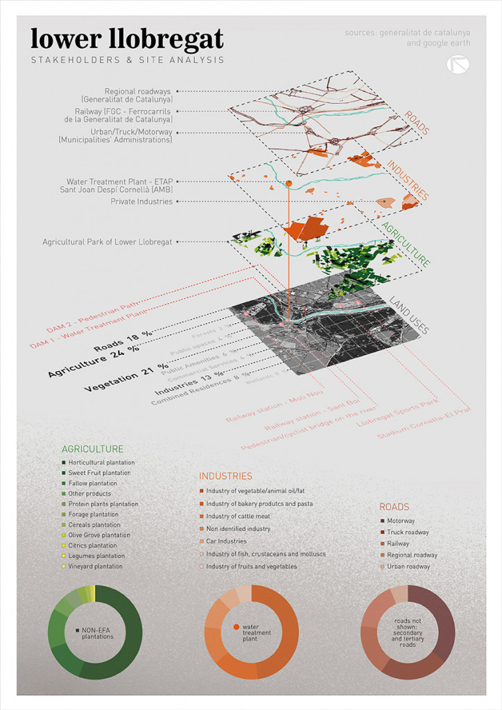
The Llobregat River represents one of the main sources of water and power generation for the city of Barcelona and Catalonia in general. For the Internet of Cities Studio, we deeply analyzed the part of the river we will be mainly addressing on our project, which consists of a portion of the Lower Llobregat Agricultural Park.
By filtering Land Use datasets on QGIS and manually marking some important locations, we could extract the areas of each typology inside our site, and through the creation of a spreadsheet, identify the percentage of each one of them in order to classify which stakeholders have more influence on our area: entities related to Agriculture, Roads and Industries, the most relevant Land Uses. We also filtered the subdivisions of these three on QGIS, obtaining the areas of the categories of Agriculture, Roads and Industry, and created charts on a spreadsheet to analyze the hierarchy amongst them.
From that, we imported the shapefiles on Grasshopper and created an isometric map, isolating the three main Land Uses. By doing that, we could point out the results of a research on the stakeholders that manage them, and classify with gradients of colors the same hierarchy of area that is shown on the charts.
Poster – Lower Llobregat analysis
- Source of datasets: Generalitat de Catalunya
- Source of additional information: Google Earth
Lower Llobregat: Stakeholders & Site Analysis is a project of IAAC, Institute for Advanced Architecture of Catalonia developed at Master in City & Technology in 2020/21 by student: Laura Guimarães, and faculty: Diego Pajarito.