The land use distribution of a block, neighborhood, or district can be seen as a valuable data point that tells a story about that particular urban form. In the OECD article “The Governance of Land Use,” the authors write “Land use affects individual and collective wellbeing and is a critical factor in meeting the overarching goals of environmental sustainability, economic growth and social inclusion.” Thus, we believe that being able to simulate land use distribution as a primary data point within a neighborhood opens the door to modeling additional environmental, economic, and social metrics. This tool would then prove valuable to a number of professions including real estate strategists, urban planners, economists, financial services, sociologists, etc.
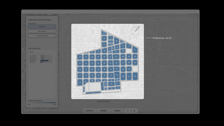
The site that we chose was the district of Poblenou. This is a good reference point to build out a methodology, as it is a site that itself is going through urban regeneration through the 22@ project. Additionally, it provides the grid typology, which makes it easier to assess a geometrical unit and its neighbors, as well as pull data from other grids within the city. Our simulation is ran currently with the intention of providing land use distribution at a block level, although we would like to eventually move the calculations to the unit level. We would also like to introduce typologies as another variable within the simulation. For simplicity, we are also dividing land use categories into Residential, Commercial, Institutional, Industrial, and Recreational. The official zoning categories are much more extensive, but we felt that as a group this categorization paints a strong picture within the simulation.
We wanted to focus on two different influential drivers when tackling this simulation. One being the neighbor dependencies. Our assumption regarding dependencies is that land use distribution of a block can be dependent upon the neighboring block. Our current methodology is assuming that a block will change based on the average of the neighboring blocks. This dependency provides us with a cascading effect in the simulation, as blocks are always evaluated against their neighboring blocks and can be changed in every iteration. We want to furtherly mature the neighborhood dependency based on additional research. In the research publication “Measuring the neighborhood effect to calibrate land use models, the authors state “The neighbourhood effect includes the inertia of land uses over time, the conversion from one land use to another, and the attraction or repulsion of surrounding land uses.” We currently tackle all three of these within our model, but are looking to complexify the rules to create a more accurate non-linear model.
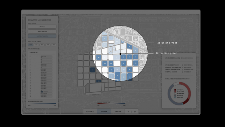
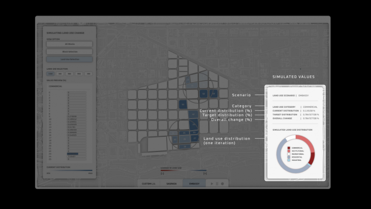
Our second driver is the target distribution of a particular city. This target distribution can have a specific geolocated intervention, or affect the whole site. For specific interventions, we look at two different case studies. The first case study is placing a major tourist attraction in a specific point on the site. Depending on the tourist attraction, it will have a certain radius of it’s affected zone, due to more major tourist attractions being able to affect a larger area than smaller ones. In doing this, we need to also come up with the target land use distribution itself, which is done by analyzing data of similar tourist attractions within the city. This is done via qgis and taking data from OpenStreetMaps. The OpenStreetMaps is plugged into QGIS where we can analyze the distributions at a geometric level. We can therefore assume the spatial distributions of effect and use the overall distribution of the affected area as our target distribution. The second case study is the embassy example, where we place an embassy within the site and simulate the effects nearby. Using the same process with OpenStreetMaps and QGIS, we take land use distributions from actual embassies in Barcelona and measure the land use distribution of the surrounding blocks. Our simulation can also handle standard land use planning policies without a specific intervention. This is the most common use case, as urban planners often set a target distribution for an urban regenerative project, which could be plugged into this tool. For example, we’ve also programmed a use case where we take Poblenou and use the Eixample land use distribution as the target distribution.
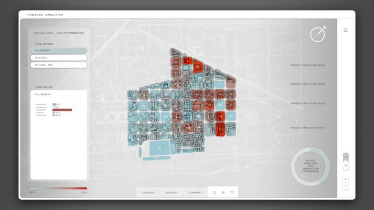
Once the simulation starts, every block within the site with its own respective distribution will be evaluated against the average neighbor distribution and the target distribution (if within the targeted zone). If the block is within the targeted zone, it will take the differences between the block in question and both the target distribution and average neighborhood distribution. The distribution that drives a larger difference will be the one affecting that block, and the block will move closer to that distribution. We define this movement as the difference of the block and said distribution divided by a defined time factor. This is because change takes time in urban development, and if it’s a 20 year project, it may only move 20th closer in difference to the target or neighboring distribution. Since every block is evaluated within a specific iteration, there is a chance that every block within the site could change after one iteration. After each iteration, there is a new current average distribution of all the blocks, and the simulation stops once this distribution approaches the target distribution.
Moving forward there are some opportunities to improve the methodology. For one, the neighboring dependency can be more scrutinized with research, as taking the differences of the averages needs to be backed up with more clarifying data. Secondly, we want to display additional environmental, social, and economic metrics that come from changing land use. Thirdly, we want to mature the concept of time within our simulation. Lastly, another goal would be to improve the resolution to the unit level, as we are currently simulating land use change for each block within a particular site.
Simulating Land Use Distribution is a project of IaaC, Institute for Advanced Architecture of Catalonia developed at Master in City & Technology in (2019/2020) by:
Students: Kushal Suraiya, Rovianne Santiago, Andrew Saltzman, Jochen Morandell
Faculties: Alex Mademochoritis, Eugenio Bettucchi, Rodrigo Aguirre