· LAGOS CAPILLARIES ·
REWILDING LAGOS
Lagos Capillaries is a project exploring the naturalisation of the concrete drainage canals of Lagos, Nigeria, within the framework of rewilding while creating spaces for community integration and productive urban landscapes for farming. 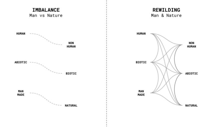
The idea of rewilding within an urban context often connotes the ‘introduction of nature’ into the city. This concept insinuates the othering of man or ‘nature’ because humans and the habitats we build can also be considered part of nature. Therefore, it is not unreasonable to conclude that man and what we often easily refer to as nature are abiotic and biotic components of our natural world. Furthermore, humans and other non-human forms of the biotic component appear to be constantly in conversation. From plants growing on abandoned quarries or new flora and fauna ecosystems springing up in lost spaces within cities, other non-human forms appear to be almost negotiating their existence within human habitats and vice versa.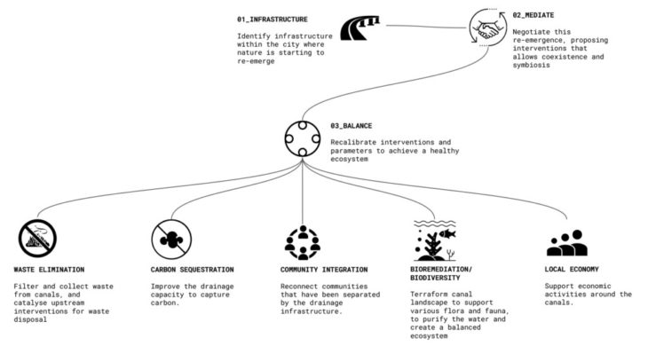 On this premise, our approach to rewilding was to find one of such negotiations, usually an underused or underperforming infrastructure in the city where plants or animals have emerged or are existing but failing to thrive, and negotiate that emergence/existence to achieve a balanced ecosystem. In the context of Lagos, the concrete drainage canals built to channel water from the hinterland into lagoons and rivers are surprisingly also home to several native plants and marine lifeforms. For this project, the objective became naturalising the canals, allowing them to perform more efficiently with further goals of enriching existing biodiversity, tackling waste pollution and water purification, carbon sequestration, and promoting community integration and local economy.
 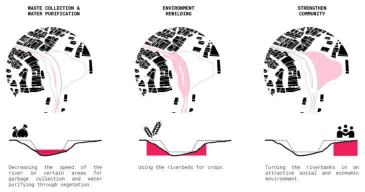 The project development went through analysing the context to identify urban parameters that would computationally drive the terraforming of the canal landscape, optimisation of this new landscape and creating connections, bioremediation, urban farming and community integration strategies.
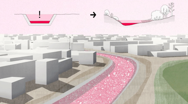
XL/ URBAN PARAMETERS
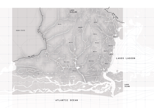
We located our design in Lagos, the commercial capital of Nigeria, located in the southwestern part of the country in west Africa. The most populated city in Africa, it has a high population density of 17.000 people/Km2 and a tropical savanna climate, characterised by high temperatures and humidity, averaging over 23ºC and 55%, with clearly defined wet and dry seasons and not significant wind speeds. Lagos is culturally and economically booming. The shift towards an industry-based economy makes it the point where people from all around Nigeria are migrating. Culturally this means the confluence of all the different ethnicities present in the country generating a rich social background.
 Geographically it is divided into Lagos Island and Mainland, with Lagos Lagoon separating them. The mainland has a network of concrete canals that run through the city like capillaries carrying wastewater to the lagoon. While Lagos is surrounded by water, most of the intense flooding in the rainy season occurs in the hinterland. This has to do with the massive pollution that clogs the drainages, rendering canals and gutters inefficient.
 These canals are a barrier between communities and undergo different realities that go from people embracing their reality and benefiting from the waste collection to people avoiding any sort of interaction with them.
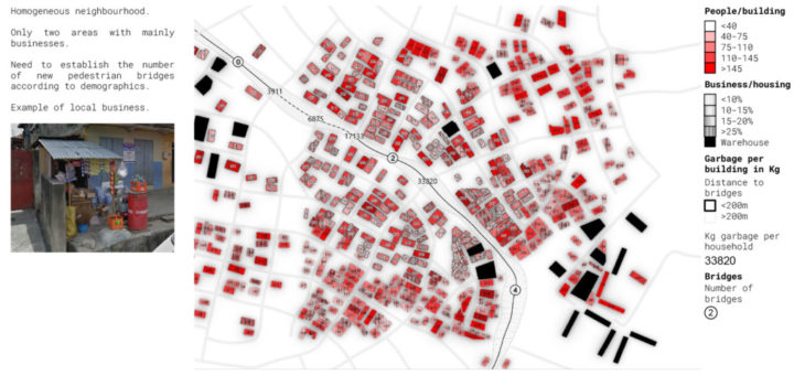
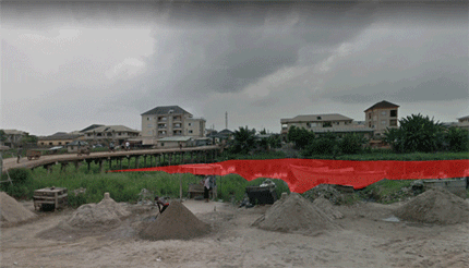 We chose a segment of a canal located in one of the most highly populated and flooded areas in Lagos Mainland, in the district of Shomolu. Analysing the demographics and social habits in the area we came to identify the different needs and potentials of the site. We are located in a highly-populated area with a homogeneous distribution. There are two business areas with warehouse buildings. Local economy is carried out in tiny kiosks in the ground floor of housing buildings. We have set the number of necessary canal crossings through the population density of the neighbouring areas.
L/ CANAL OPTIMISATION
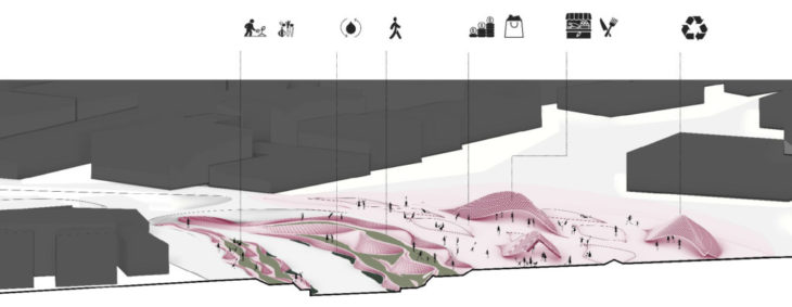
Our first step towards terraforming the canal landscape was to optimise the canal geometry and have it work for our rewilding and community integration goals. We sought to redefine the upper and lower boundaries, and established connections in areas where the canal disconnects communities.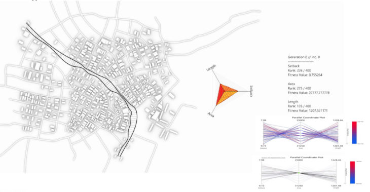 For the upper boundary, we wanted to maximise the setbacks and land area of the canal while minimising its length.With these goals, we ran the canal geometry through an evolutionary solver to find an outline that best meets our fitness goals. From the resultant analytics, we saw that we had countering goals, and to trade off to get the best result, we looked at the average and most repeated area values and selected the iteration that gave the best setbacks and lengths.
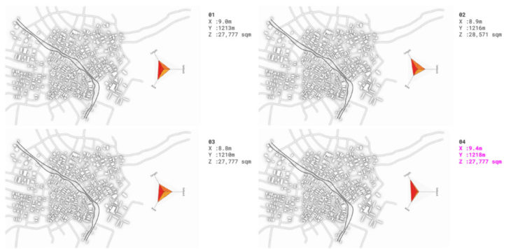 The lower interior boundaries went through a similar optimisation process. We referenced Bernoulli’s principles to create areas of high velocity and areas of low velocity by varying the width of the canal. The narrower areas will have higher water velocities and will be water aeration zones and the wider areas will have slower water velocity and lamina flow which will get oxygenated water good for supporting flora and fauna. These narrower areas were planned under the bridges and wider areas in between bridges.
Bridges are not mere connections but able to add programmatic and social value to the site. Their geometry blends the two sides of the canal banks and is able to widen up or narrow down depending on the community needs.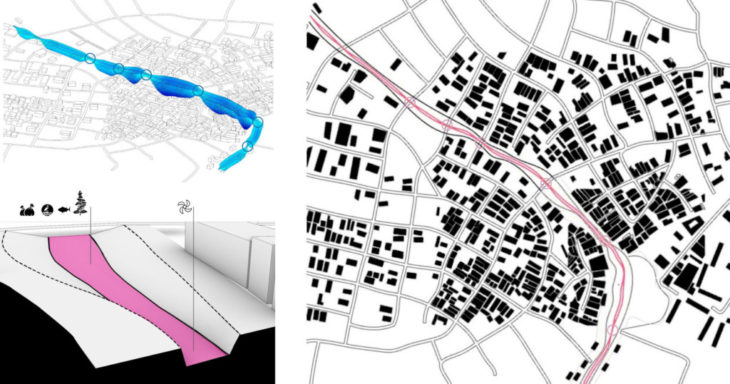
M/ NATURALISATION
Three key points establish our approach to the canal bed area. Our intervention seeks to structurally reinforce the river banks, allowing spaces for bioremediation and urban farming.
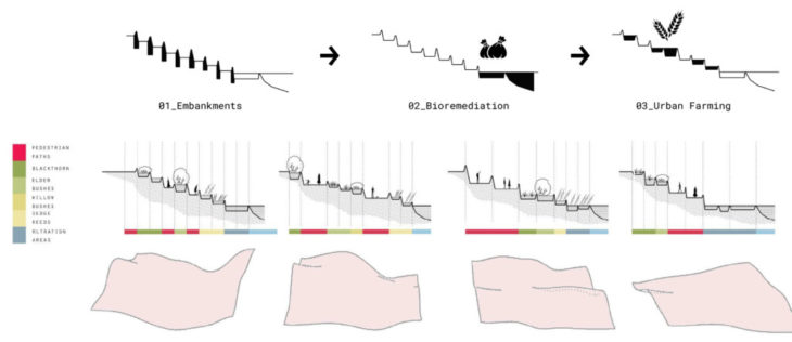
We are inspired by braided river patterns, as a terra forming strategy, organically dividing spaces of different use.
Starting from weaved curves a script is further refined into producing curved embankments. A variation which allows appropriate average surface for farming crops and that blends to the scale of the site is selected.
These woven curves, embedded below water level, are a final lattice module for a natural waste filter system. Here, rock boulders are arranged on a gravel bed within this unseen lattice such that waste gets trapped in the spaces between the rocks. With average precipitation of 315mm, the embankment rocks will have to be a minimum 450mm diameter to protrude above water levels in the rainy season. The riverbank becomes a new wetland ecosystem with plant and animal species native to Lagos. It will function as nature’s kidneys by removing pollutants from the water. In addition, active bioremediation strategies included bio-attenuation by introducing bacteria and nutrients to mineralise organic pollutants.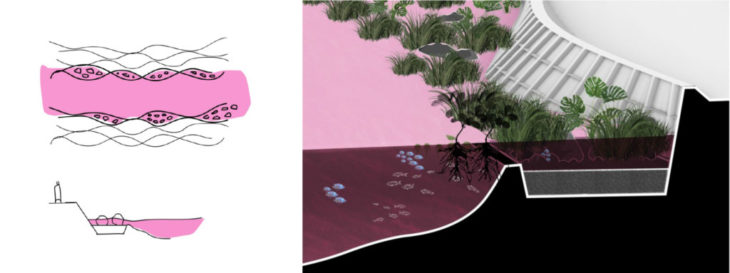 Introducing agriculture into these urban ‘’wastelands’’ has been a major aim since the beginning of our discussions about the topic. Between wetlands and agriculture there exists a millennial relationship that has proved to be destructive towards wetlands. It is therefore our aim to reintroduce a symbiotic relationship between them tackling issues of food production that the area faces.
 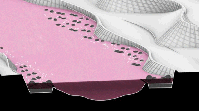 We achieve this by selecting crops that are part of the local diet and at the same time appropriate for soils with high humidity. We propose their placement gradient-wise, with rice at the base, continuing with pumpkin leaves and molokhia and then yam in the flat surfaces, their strong roots further structurally reinforcing the embankment. These agricultural islands can be extended beyond the riverbanks, in empty areas as needed.
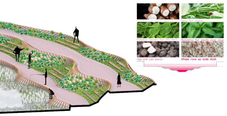 Materials are chosen in relation to the vicinity to water, introducing rocks and sand in the immediate shore, cedar, fir and hemlock wooden elements for constructing embankments +2m from water level. In the urban level mixed systems of wood and steel are used for constructing pavilions and other structures. Collected plastic from the canal can also be used in mid level and urban level as prefabricated blocks.
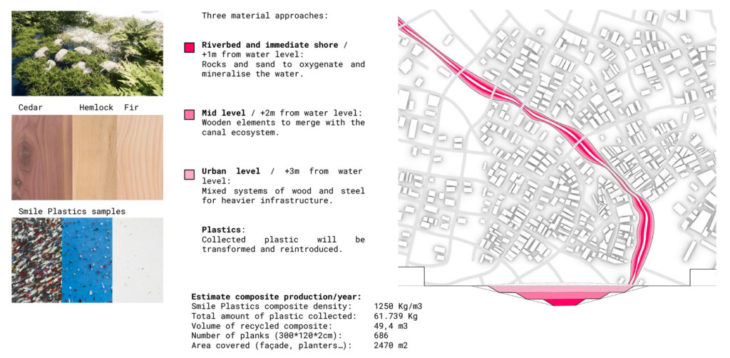
S/ COMMUNITY
All the previous strategies are implemented in a chosen site along the banks of the canal that allowed us to show a rich programme of rewilding, connection, urban farming and community spaces. These functions are naturally entwined, none being the central one.
Riverbanks are spaces of making this transition, from a concrete canal bed to a natural one, possible, allowing water purification through vegetation and farming. At the same time pedestrian paths are provided, creating recreational and leisure areas.
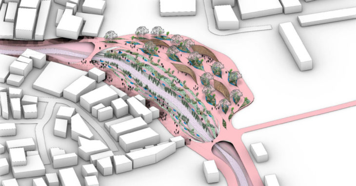
Adjacent empty areas are treated as a filter, between the river banks and the neighbourhood. Besides agricultural islands and pavilion structures are introduced. They are open and flexible envelopes for various activities to happen, starting from market spaces to workshops of the collected waste.
The lattice seeks to be a mediator between the current state and the proposed one, only a step and not a permanent intervention. It is a natural interface that provides the necessary support for flora and fauna to grow and then withers away.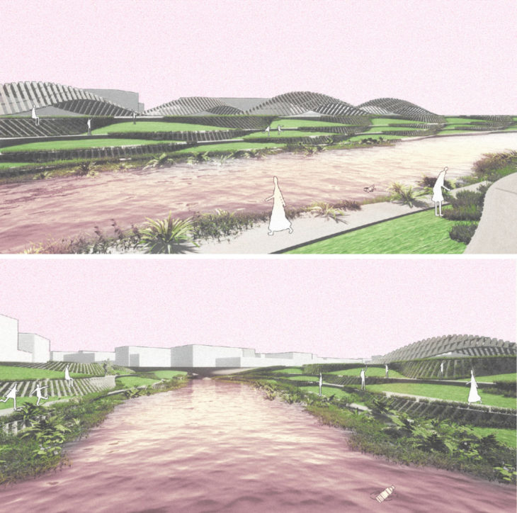
CREDITS
Lagos Capillaries is a project of IAAC, Institute for Advanced Architecture of Catalonia, developed at Master in Advanced Computation for Architecture & Design (MaCAD) in 2021/22 by:
Students: Erida Bendo, Lucía Leva, Pablo Antuña and Oluwadamilola Akinniyi
Faculty: Arthur Mamou-Mani, Fun Yuen and Krishna Bhat