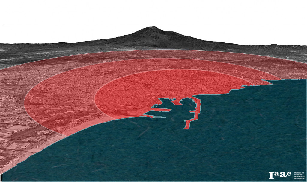
Catania is one of the largest cities in Italy and the second metropolitan city of Sicily, reaching about one million inhabitants with 58 regional municipalities.

It is located on the Eastern coast of the island, on the slopes of Mount Etna, that stands tall over the city and dominates the skyline.
The city is characterized by a complex urban system as a result of a rapid growth in the last fifty years, which brought to a general urban sprawl, creating new types of peripheries, mainly in the North.
Although Catania is a port city since Roman time, its relationship with the sea has always been complicated.
A long part of the coast in fact is characterized by a long railway line, inadequate urban roads and discontinuous points of contact with the sea.
The analysis
An analytical approach stands at the basis of our strategy. We conducted a qualitative and quantitative analysis in order to integrate information derived from cartographic sources and socio-economic data (ISTAT).
The result of this analysis is the overlapping of layers that helped us to read and try to understand the city better.
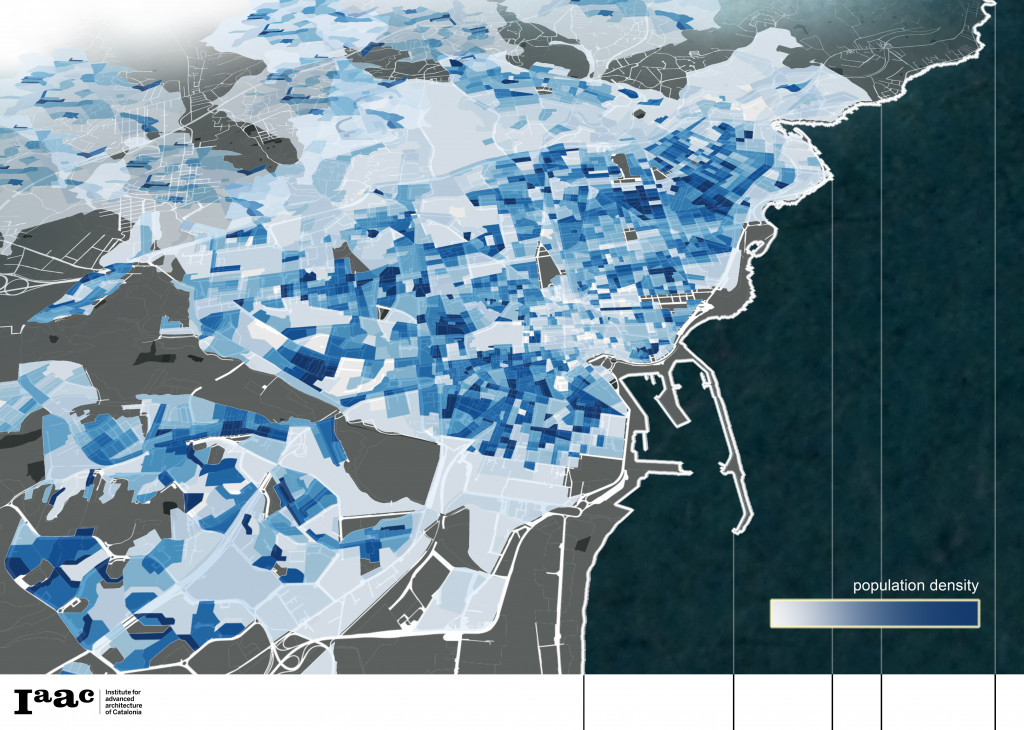
Population density map of Catania _Source: www.istat.it/it/archivio/10431
If we look at the distribution of the population density, it appears quite evident the continuity among the historic center and the suburban areas, a way to highlight the uniform urban pattern that characterizes the city.
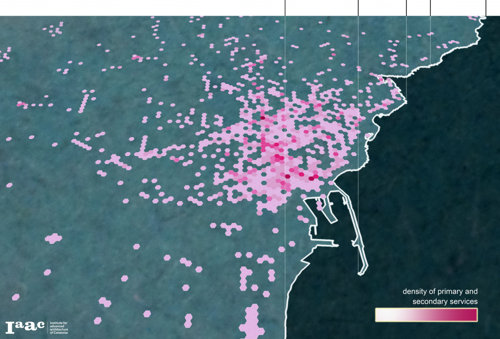
Services density map of Catania
Source: OpenStreetMap.org
A matrix settlement that it is difficult to define because apparently homogenous but fragmented in terms of services.
Actually, one of the reasons is that Catania city center has retained the centrality of services, like schools and offices, and this part of the city has a stronger attraction for a large part of the population that lives in the hinterland.
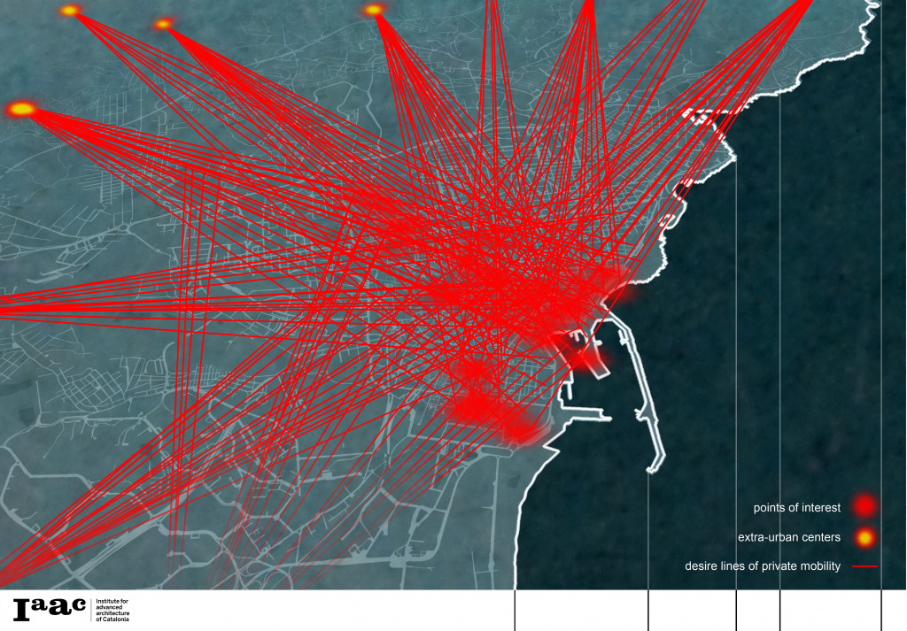
Source: PGTU Catania
In fact, the destinations of 70% of everyday trips (which are estimated to be about 118.000) are places that belong to the city center.
Source: OpeneStreetMap.org
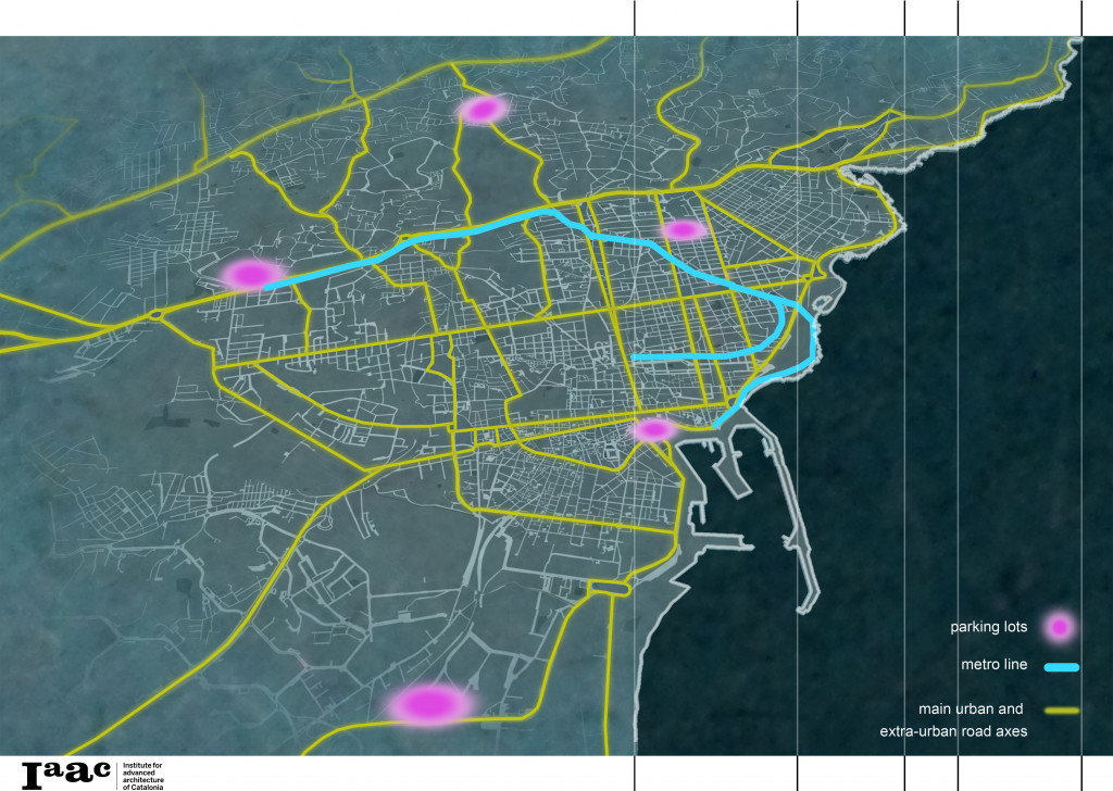
The transport system becomes every day less sustainable because it is based especially on private cars within an infrastructure that is not suitable also in terms of parking spots. This generates critical issues as road traffic congestions, low public transit ridership and high levels of fuel consumption and emissions per capita.
Source: OpenStreetMap.org
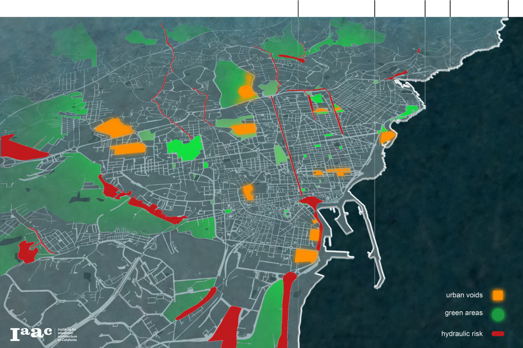
The last layer of our analysis is the combination of some of the main unexpressed opportunities, like green areas and urban voids, and the hydraulic risk map, a sensitive issue due to the increasingly frequent floods that break down on the city.
The strategy
As we have seen Catania is strictly connected with its surroundings, the attractive power of the city is testified by the many cities that through the years developed along its borders and in the surrounding territory.
This strong impact on the surrounding area has been our stimulus to think a strategy to improve the quality of life of citizens, so we believe that now it is the time to act, rethinking the city, starting from mobility and the road system.
To try to solve the problem of congestions of many vehicles that every day cross the city, coming from nearby cities, our proposal consists of the creation of interexchange hubs that intercept the private transport thanks to their strategic position, nearby the main roads, offering parking lots and allowing people to use the public transport or other ways of slow mobility.

The incentive to utilize other means of transport to move across the city is given also by the creation of greenways: a system of streets thought to greening the city, with a wider diffusion of nature through the city, exploiting and connecting the existing green areas and the current road network with the basic idea of putting all of the strategic points in communication.
This system of interconnected streets represents the key point of our strategy because it is not only a green solution to make the city more liveable. The network of green roads intercepts the parts of the city with elevated flood risk and the permeabilization of these branches represents at the same time a solution also for this criticality.
By its very nature, this grid is made also to connect part of the interexchange hubs and other critical points of the city, like disused area, urban voids and all those places waiting for intervention, representing an opportunity for the regeneration and requalification of entire districts and parts of the city.
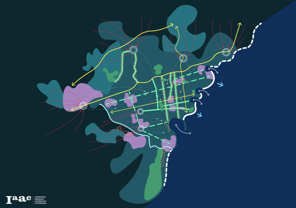
Another fundamental aspect consists of the paradoxical relationship with the sea, although the city was built on the coast.
For this reason, we think the waterfront has to be redesigned because the only connections with the water are in correspondence of few points. Among these spots, the approach to the coast is almost totally prevented while the situation appears apparently different along the northern and the southern coastal stretches.
In the first case the access to the littoral is almost free, but not so easy because of the morphology of the terrain, while in the southern part even if it is easier to reach the water, the real obstacle is represented by the numerous bathing establishments that have privatized that stretch of beach.
Revealing the waterfront to Catania means working on a network of places, functions, grafts and stitching between the coast and the urban pattern.
This is our vision of Catania, analyzing its characteristics, and trying to offer a valid strategy for a better future of the city and all its citizens.
CT flow_shaping the strategic future of the city is a project of IAAC, Institute for Advanced Architecture of Catalonia developed in the Master in City & Technology 2020/21 by Students: Simone Grasso, Matteo Murat and Faculty: Manuel Gausa, Nicola Canessa, Giorgia Tucci.
