 Abstract The draft study to the next document is a transportation project implemented by the Mayor of Bogotá, Colombia, in the area of Ciudad Bolivar, one of the most overlooked and higher infrastructure problems, social, accessibility sectors, public space etc. The project is an Aerial Cable, which could benefit thousands of people, as it reduces the travel time from home to Transmilenio portal, which is the mass transit system of Bogotá. Aerial Cable This system will not change the aforementioned problems of this sector, but could help improve travel times that though they sound very simple, is of great benefit to people who previously took them go home to station about an hour in urban buses, the cable can they take about 15 minutes. This project aims to shift some mistakes in the past, on issues of transport infrastructure projects, and being managed as an integral urban project than simply connecting point A to B without considering what passing on its route or immediate surroundings. They are analyzing the urban and social opportunities that can be integrated project around the cable stations, developing infrastructure projects, public space, and education and integrate into the community to participate and be part of the project. Within the regulatory framework are problems legality of neighborhoods, areas that are protected land systems, sectors at risk of removal of masses, invaded rounds broken, damage to the ecological structure, which makes intervention to occur and the community outreach more difficult and requires more detail in the decisions that want to take. All this occurs within a comprehensive improvement plan that can take several years to develop, but it is understood in any successful urban project to develop all the steps that are required.
- The Site
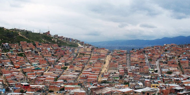
Ciudad Bolivar stands out as one of the locations with the highest population receiving product expulsive phenomena displacement processes and of course the conflict armed, this added to which historically has been one of the locations with higher deficits of urban infrastructure, the present administration has set its sights on one of the components of urban infrastructure in order to provide mobility in this sector. The transport system wiring, although it has been contributing to the displacement of people since more than a century, now becomes an alternative and yet in a mobility strategy, displacement and connectivity in one of the sectors most difficult topography of the city. On the other hand the implementation of this urban system, at least proportionally should contribute in reducing social factors such as insecurity, lack of meeting places, and lack of facilities providing social services to the population. To complement the implementation of the mobility system, it is necessary to establish a series of actions of different urban nature that contribute holistically to benefit the population, in this sense the Capital District and also from this document will define a complementary zonal urban project cable, so that the impact and area of influence to bring this system of mobility territorially extended to a larger number of beneficiaries. The regularization of developments, legalization of urban settlements, priority areas of intervention, as well as planning tools and applied in the area of urban zonal project and articulated different actions cable deployment, management will contribute to an interagency intervention a comprehensive purpose not only contribute to a sector of the city, but also provide benefits to the general public. 1.1. Ecological Network The Ecological Network of Bogota is a key component in the urban area the system of natural waterways; in the area of influence of the system there are two arms Urban Strategy Project Cable Air Ciudad Bolívar de la Quebrada Limas, part of the Rio Tunjuelo, and, as such part of such a structure, like the Peña Colorada creek that limited to rural areas and conditions including surveying and property has not been on the north side. Like several of the channels in this basin, the Quebrada Limas was affected in his round by illegal developments in the 90s doubled the population of the town. The broken presented in the study area two arms whose channels have different topographical features, but they have in common the occurrence of several flood events in the late 90s and early last decade. In the southern part of the area of influence of the system with a channel that develops in the direction west east, is the Gorge Dam, characterized by a much lower occupation of their rounds. The plane of a third runway POT (Bogotá Normative) notes that in reality no longer exists as such it has been almost completely urbanized. The main Ecological Network should ideally incorporate the elements of the water system (channels and rounds), parks and green areas, protected land areas, malls and areas of environmental protection arterial roads mesh in a complex system points, areas and corridors with vegetation that is an environmental active citizenship and has a fundamentally public. In the study area, these elements are disjoint if not outright opposition. For ecological corridors round, that are still unoccupied stands, but are not axes of integration or tour but barriers to mobility and continuity of the urban fabric, if not scenarios of flooding and landslides. This situation makes building relationships between elements of the ecological structure and Urban Public Spaces Strategy becomes a strategic variable first order for the formulation of the proposal. 1.2. Threats by landslides and flooding 80% of the study area presents threat removal in high or medium mass, largely associated quarries and illegal constructions. The floodplains of the round of Quebrada Limas has undergone mitigation works. 1.3. Urban Services The study area participates Urban Services with 12 nodes smaller scale incorporating education and health services. Another relates to the great future urban node associated with the special management area round Tunjuelo River. Among those incorporated by the POT nodes highlights of Vista Hermosa and Don Bosco, the first of which is very close to the future station Manitas-Villa Gloria. In that vein, we can say that the study area clearly not part of the main system facilities in the city, and although there is a lot of Urban Services, some of considerable magnitude, they do not generate zonal level, a clear structure of nodes or concentrations of services. This dispersion pattern of spatial distribution of equipment is particularly problematic in an area where for topographical reasons connectivity of attractions of people is severely restricted. Furthermore, the Master Plan of Educational Urban Services did not foresee the creation or strengthening of any new node in the sector. 1.4. Urban Space System The deficit we have of public space (1.8 m2 per capita), compounded by the poor state of the parks and the lack of accessibility due to its topography. In turn, the sector has no connection with pedestrian sidewalks, malls, allowing connection between the different parks hindering access to these. Due to social problems, local gangs, drug outlets, and unsafe sites that the community does not usually frequents, mostly inhabit the parks.
- Project and its Social-Economic Context
With the above analysis of the place, it perceived that the place is unique and has its own different problems in any other area of intervention. You cannot address the intervention, as an urban project without considering the social component, perhaps in this case is the most important, since any erroneous intervention may create more problems for the sector. 2.1. Invisible Borders Unfortunately for carelessness and inattention to these neighborhoods, have generated social problems of gangs that control territory and impose a domestic law, creating invisible boundaries, which may simply be a street where the inhabitants cannot cross because other gang will prohibit them. 2.2. Retrieving the environment With the urban proposal, it is emphasized in the recovery of the main ecological structure, emphasizing the streams which over time have been invaded and polluted by growth unplanned neighborhoods. It is an opportunity to recover these water sources for residents aware of the importance that this entails, and to develop multiple activities around them, from creating parks mitigation to the creation of urban cultures that once has tried to implement without much success. In addition to the streams, the project aims to restore a quarry to return a park urban scale, which helps the soil settlement, and prevent erosion and land movement zones. As already mentioned above, this sector lacks public services, and many people are obliged to discharge wastewater to natural water sources as well as waste with this change you want to give more attention is sought the community generating this environmental impact for the recovery of this sector. 2.3. New Economy An informal economy is dominant in this area of the city, neighborhood economy, moving an internal market that suits the needs of residents. The real economy is not immune to this change that will generate a real estate speculation that makes everything change from increasing the price of land leases rooms for individuals or families living in one room is generated, makes have to find a new place to live a little further away from where they were located, unable to use the new benefits of urban project that is coming, and generating a new type of forced displacement. It is noteworthy that in turn changes the local economy, it will generate new benefits and direct and indirect economic opportunities. Direct will be those who are involved in cable project as server system and indirect jobs of people, who will benefit from a new “tourist” movement that can generate, as far as happened in Medellin, people other sectors who want to go see the project appeared a new tourism in the city. 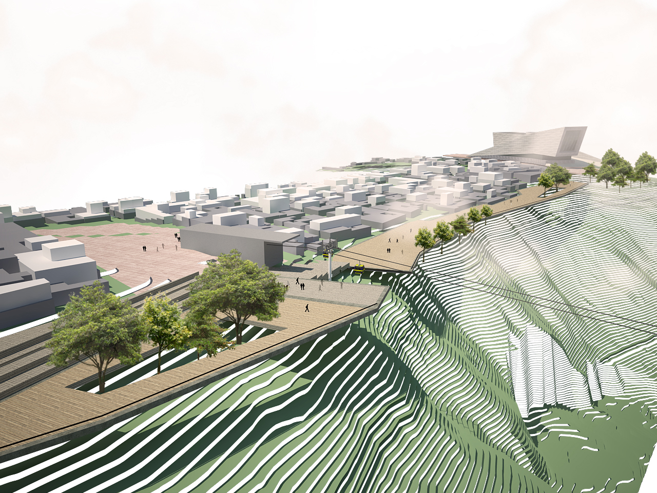 3. Final Result A project that does not provide economic, social, environmental, urban factors, is not a sustainable project in time, as mentioned above, this transport system is not connecting one point to another in space, it is to see the opportunity for change that can have, to benefit thousands of people directly or indirectly, can generate a change in the spatial urban structure, and that is why if all these factors work is successful in a very sensitive area as is the neighborhood of Ciudad Bolivar. It is critical to involve participatory community in a project of this nature, since these are frequent users, and having this type of intervention is beginning to generate and organize communities to improve urban conditions, and can get to meet many needs as the subject of facilities, public space, and infrastructure among others.