CONTEXT
With the expansion of cities, more and more land is being converted from natural land cover to dense urban fabric. This trend then in return causes urban heat island effect to heighten the effects of global warming causing climate change. To mitigate these impacts it is now crucial for cities to shift from linear to circular strategies.
In Barcelona, studies (Urban-CLIMPLAN project, CPSV UPC)have identified four main factors that are causing urban heat islands:
- Urban Morphology
- Land Uses
- Landscape Design
- Selection of Materials & location of Vegetation
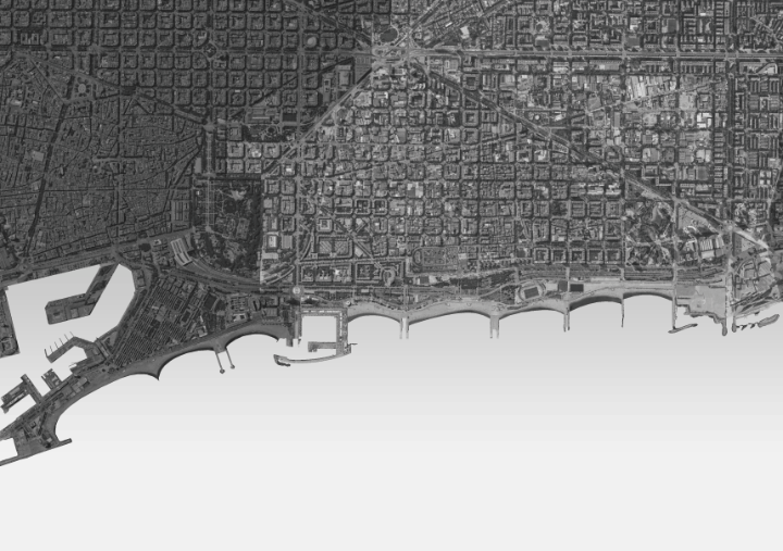
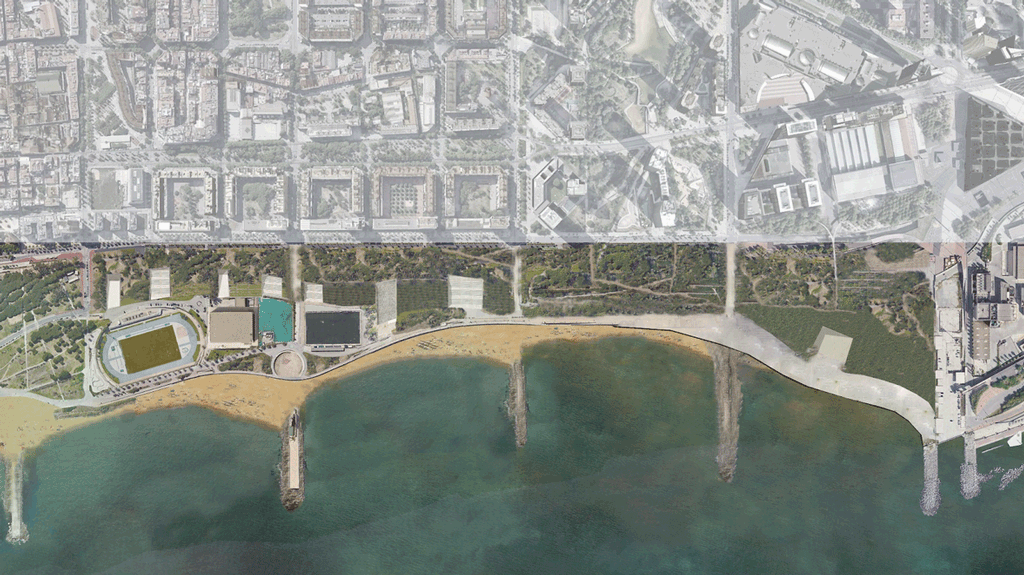
To explore the implementation of a circular strategy addressing the factors mentioned above we selected the neighbourhood of Diagonal Mar within the district of Sant Marti. The major physical feature of this location is that the highway acts as “the great divide” between the neighbourhood and the sea. The project’s main aim is to bridge this gap, while proposing a circular economy.
This last area is the district of Sant Marti; it is called the Innovation district. Within this is namely the 22@ district, an initiative to transform the old industrial district, a strategic concentration of knowledge-intensive activities. Within this district we identify the neighbourhood of Diagonal Mar. This neighbourhood is interesting to us because of the least concentration of built structures compared to the rest of Sant Marti, and this is where the traditional Cerda grid of Barcelona disintegrates, a change in the urban fabric. Other indicators we looked at include the unemployment and density; our area of interest has a high unemployment rate and relatively low density, again suggesting opportunity for local intervention.
Looking at the whole district to compare our neighbourhood, we looked at the economic activities in terms of Amenities, Industry and Services. In this neighbourhood there is a relatively low concentration of activity. Looking at the specific hubs around the Sant Marti district, we notice that this neighbourhood is surrounded by the design, ICT, and energy intensive sectors. Having our neighbourhood at the centre of this small triangle is interesting for us.
We can start looking at the amount of built structures in comparison to the open spaces in this neighbourhood in comparison to the rest of the district. The amount of open space for the whole neighbourhood is 82 %. The neighbourhood borders on the point where Cerda’s plan starts to disintegrate and becomes more open.
CONCEPT
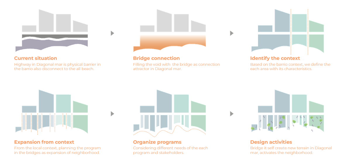
To connect the three major innovation clusters, the fourth hub we introduce is the Education Hub. Diagonal Mar has a low concentration of educational bodies at the moment and thus the education hub can serve as the center both spatially and the link between the other three hubs. Once the new hub is established the next part would be to connect the fragments of the neighbourhood using the new hub as the nucleus.
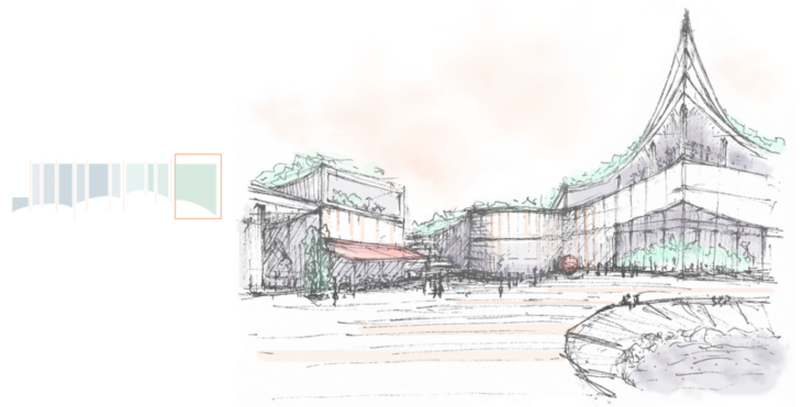
The last chunk consists of the tall office towers and the convention centre facing the Forum park towards the sea. Sandwiched between the convention centre and the Diagonal is the Diagonal Mar Commercial Center, which is the largest shopping centre in all of Catalonia. Adjacent to this and at the edge of the city sits the museum (Museum of Natural Sciences of Barcelona) The question for us was, What happens in the large Forum space?
We identify 3 major problems with our chosen neighbourhood; the lack of connection within the area, the unused open space, and the disconnect from the edge of the neighbourhood to the sea, split by the promenade.
After our analysis led us to identify the major innovation clusters, we began to think about a connecting variable that links them together. Here the plot of educational bodies shows a low concentration in Diagonal Mar. Our concept plans to capitalize on this opportunity and introduce an education hub as part of the innovation district. This education hub serves as the centre both spatially and, as previously mentioned, the linking variable between the concentrated centres. So, moving forward, our concept puts education at the forefront.

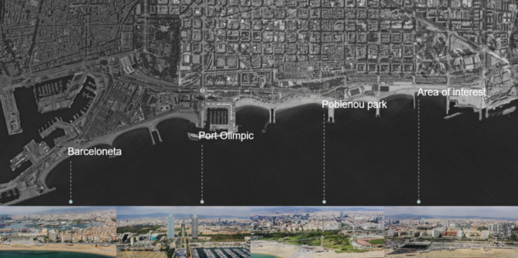
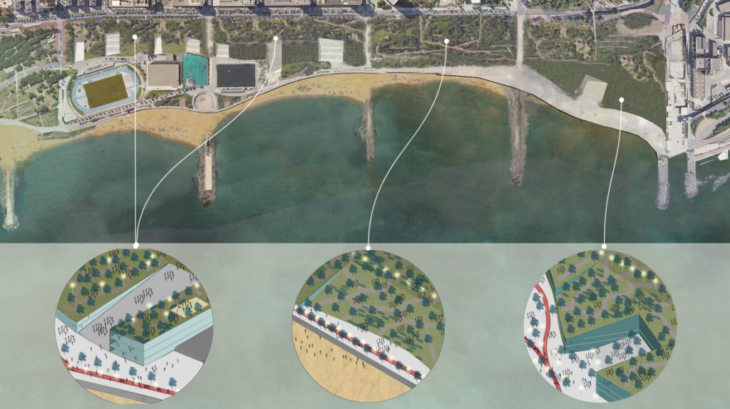
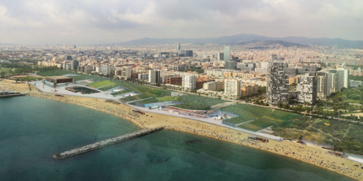
Our area of interest in the context of Barcelona is the finishing line of the city’s waterfront. Different points of interest consist our design intentions in the large scale. Barceloneta, where the waterfront starts, Port Olimpic where essential landmarks exist, Poblenou park where a green open area is placed in the beach and Diagonal del Mar where our intervention comes. By expanding the existing waterfront in order to create a consisted promenade.
The expansion of Poblenou Park into our site will increase the connectivity and will create a new green urban infrastructure for the neighbourhood. And the connection with the existing urban fabric by keeping the main axis and expanding the neighbourhood towards the water, the physical limit of the city. By these intentions we want to create one entity one waterfront that will be lively, will increase the connection with the city centre and will support the new educational hub that we propose.
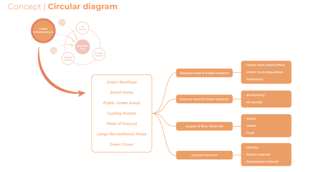
We also considered the Barcelona Nature Plan for 2030. The Green Infrastructure Concept is introduced there to connect nature with urban areas. The list here are the components we are implementing in our design which is from the list from this Plan. Based on this, what we propose create positive externalities, that all benefit the circularity on the small neighbourhood scale.
EXTENDING THE WATERFRONT
The dividing point along the waterfront is where the Poblenou Park ends abruptly as it meets the La Mar Bella Municipal Sports Complex. Our proposal would extend the Park and the promenade till the end of the waterfront, in order to not disturb its continuity. This will create a new green urban infrastructure that will then connect in the direction of the neighbourhood via Parc Diagonal Mar. This green infrastructure will increase connectivity between the centre and the education hub and will house new economic activities distributed throughout.
In accordance with the Barcelona Nature Plan for 2030, the green infrastructure includes green rooftops, small parks, public green areas, cycling routes, large recreational areas and green cover. The green infrastructure would impact by reducing the urban heat island effect, increase CO2 absorption, regulate water cycles, increase biodiversity, etc.
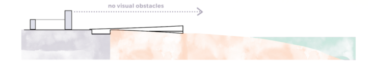
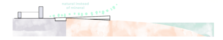
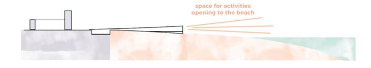
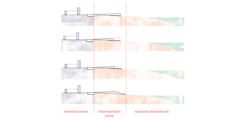
The design is an answer to the surrounding of the site. It doesn’t create visual obstacles for the existing buildings while at the same time it offers pleasant view to the sea and greenery, instead of the existing mineral tissue. At the same time it creates an intimate space for the previously mentioned activities to take part in.

ACTIVITY BASED DESIGN
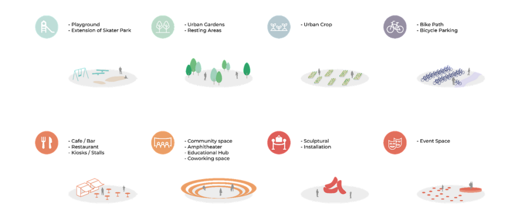
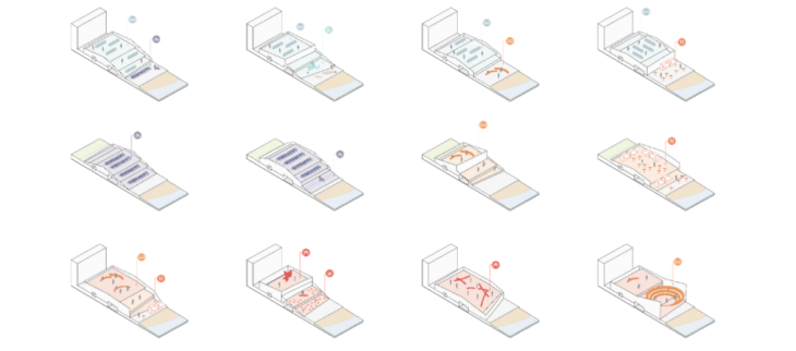
When it comes to our design interventions, different scale of interventions, designed by considering the context, promenade and highway side. Width, depth and height can be determined by the program what we are gonna propose.
- Urban crop : playground, community, food+beverage
- Green : bike path, bike parking, food+beverage
- Educational Hub : co-working, conference, event, exhibition, amphitheatre
Activities introduced on top of the structure
So to put all of those strategies together, and come up with a coherent masterplan, we propose a new urban area that functions in two levels. On the roof, we gain a new biological landscape of the city’s waterfront that works as a park, urban garden and also pedestrian or cyclist communication. In parallel, at the ground floor, we imagine activities that are establishing a network that works on the scale of the neighbourhood, city and even region.
Activities introduced below the structure
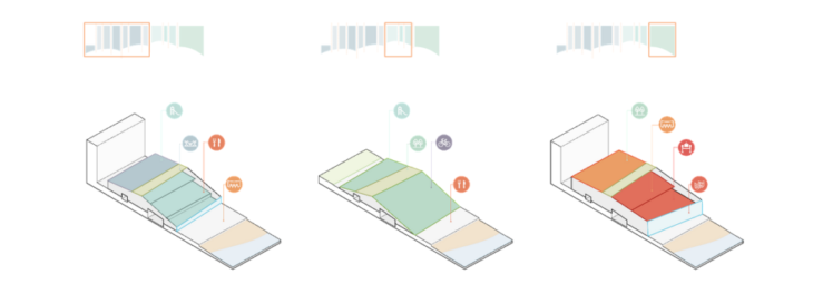
Typologies of spaces proposed are to be divided principally into three categories, depending on their character – starting from the extension of the neighbourhood, through those corresponding to the parc, proceeding to the educational hub being the main propeller for introducing stakeholders into our site, to eventually finish by the landmark. In our opinion it’s existence is crucial for this place to visually close up the perspective for the visitor approaching from the side of the city center and also being an important ending point helping to grasp distances and dimensions of the site.
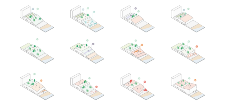
Here we can see a little bit more detailed representation of how we understand those characters and how our intervention is actually a way to break the scale of surrounding, quite monumental urban tissue into more accessible, being more adequate to host life in proximity to the beach. We imagine a multitude of spaces, creating more or less private, intimate and open areas depending on the needs and opportunities of their placing within the site. We can visualise for example a cinema above or under the structure, workspaces, urban gardens, cafes, restaurants or galleries….
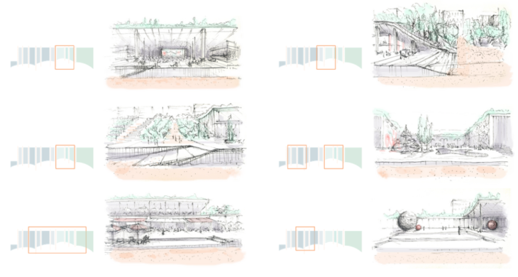
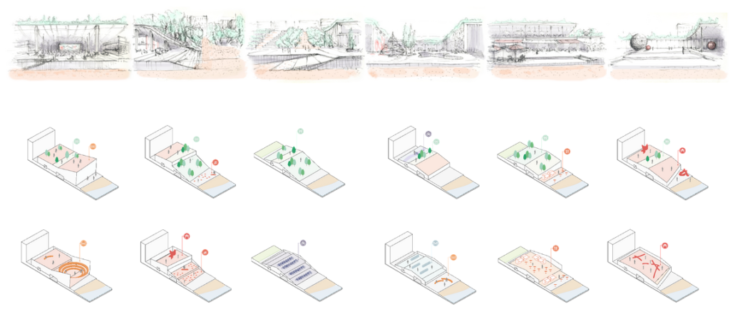
By mixing and matching the typologies proposed in the our catalogues of activities, we understand how those spaces work and what would be the most suitable function to happen in this particular place with respect to the surrounding that it corresponds to. In order to end up with the heart our intervention – the hub for students, workers, inhabitants and visitors – designed in the way to potentially become an symbol for the community of Diagonal Mar. Bridging the gap is our vision of the new waterfront of Diagonal Mar i El Fron Maritinm del Poblenou area through a circular urban design. In the large scale is creating a more balanced green distribution in the city.
Bridging the gap is a project of IAAC, Institute for Advanced Architecture of Catalonia developed at Master in City and Technology in 2021/2022 by Students: Aida Hassan, Jiyun Lee, Julia Mcgee, Dimitris Lampriadis, Weronika Sojka and Faculty: Laura Narvaez Zertuche, Bruno Moser, Andy Bow