Master in City & Technology Second Year 2018/20- Term II
Seminar Name: Artificial Intelligence in Urbanism I – Computers supporting Urban designers
Total Hours: 20 hours
Faculty: Diego Pajarito
Syllabus
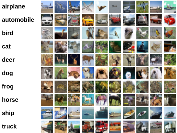
Source: CIFAR-100 dataset
Artificial Intelligence – AI, as compiled by Legg and Hutter, has been defined mainly as a capability of a computer system to perceive the environment and take actions to maximise the chance of successfully achieving the defined goals. When it comes to urbanism, we might not expect computers to perceive the urban environment or generate interventions directly in the city. Urban designers have a crucial role in adapting the features of artificial intelligence to the formal (and also legal) decision making processes in cities. For successful adoption, a better understanding of artificial intelligence, its capabilities and limitations, is needed.
Machine learning, as well as big data, is a technology capable of supporting multiple disciplines. From computer vision, mathematics and statistics to geography and social sciences, all demand tools and methods to understand problems and tailor better solutions. However, the information describing these problems limits how effectively AI can support.
This course aims to provide a critical review of AI methods and techniques from the perspective of urbanism. At the end of the course, students will clearly understand the current limitations of adopting AI into Urbanism. Firstly, by identifying the gaps between the designer and data scientist approaches to data-driven research, secondly, by critically evaluating common data sources used in urbanism. Lastly, by discussing the opportunities to feed AI models using such data sources.
Students will develop a standard example of AI while understanding the general process leading to it, the milestones and expected KPIs. Later, the students will implement a modified AI analysis process within the domain of urbanism. The two exercises will serve to identify the limitations of this data-driven approach and feed students’ discussion about the implications in their area of interest, environments (e.g., topics, cities, countries or cultures) and master thesis project.
During the course sessions, students will implement an estimator for image recognition using the classical – CIFAR-10 dataset. Before this implementation, there will be an introduction to AI and the role of images in the analysis. As the second exercise, students will use a dataset more relevant to the field of urbanism to analyse. Moving to a different dataset will make students face the challenges of deploying an AI estimator from scratch.
A series of discussions, based on the practical exercises and the reviewed literature, will serve to infer potential uses of AI in urbanism as well as to find connections with their interests and the master program.
Students will present an evaluation of the potential benefits of adopting AI in their personal research. Additionally, students will select, if available, or design, if it does not exist, a dataset which potentially feeds an AI model for urban-related research. The presentation will complement the dataset description. Students will finally submit a blog post that briefly describes their work and opinion regarding AI in urbanism. The course will support students during the development of their master thesis research, allowing them to integrate additional acquired across the Master in City and Technology.
Faculty
Diego Pajarito got his Ph.D. in Geoinformatics as part of a Marie Curie ITN Action – Joint doctorate between the Universities of Münster, Universitat Jaume I and Universidade Nova de Lisboa (2018), and the MSc in Information and Communication Sciences from Universidad Distrital de Bogotá (2014). He has performed research for the Spatio-temporal analysis of sustainable transport and other urban systems as well as for data collection techniques through mobile devices and crowdsourced data collection. Diego’s interests are the simplification of data collection and analysis for non-expert audiences when it comes to considering it within a geographical context. He has been a lecturer of courses on spatial analysis, big data and spatial databases in Colombia, Universidad Distrital (2010-2015) and Universidad Autonoma de Bucaramanga (2014). He has also been a consultant for geospatial analysis and high-performance computing for different agencies in Colombia such as the Ministry of Agriculture (2010-2015), Institute of Environmental, meteorological affairs (2010, 2012, 2014), Ministry of Justice (2014), Geographical Institute (2007-2010), among others. Daniel is the “Data Scientist” of IAAC’s Advanced Architecture Group and seminar faculty of the MaCT.
