Unpark your ambitions… Forever – A London Case Study is an Internet of Cities studio project concerned with the repurposing of car parks in London. With local government proclaiming its ambition to make parts of the city car-free by 2025, we are invited to reflect upon potential new uses for car-centred infrastructure like underground, surface, and multi-story car parks. Indeed, these structures – often vast in size – may soon face obsolescence and subsequently, become suitable for conversion. While in recent years tentative attempts have been made to repurpose car parks into new, creative structures – such as outdoor cinemas, art galleries, storage places, and the like – there is an apparent lack of systematic guidelines which elaborate on the context- and architectural-specific challenges and opportunities of repurposing car parks. This studio is concerned with filling this gap by presenting architects, planners, and government agencies with a set of in-depth guidelines on how to successfully convert car parks with distinct typologies into new structures. More specifically, this studio presents guidelines on the repurposing of car parks into productive ecological infrastructures. Such structures come in different typologies and can take the form of rooftop and recirculating farms, community gardens, vertical parks, green facades, etc. Essentially, these infrastructures add to the agricultural and green landscape of the city and present its residents with a wide range of services which include food production, urban cooling, community building, as well as education and research. The guidelines articulated during this studio determine how specific typologies can be tailored to the needs of a specific neighbourhood and how these can be implemented based on the architectural characteristics of a carpark.
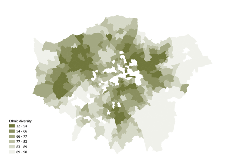
The Internet of Cities studio is complemented by a Digital Tools & Big Data seminar. The goal of this course is to provide students with experience handling common tasks of big data, data science or data analytics. The course provides a practical perspective of the main activities developed for urban analytics. From data collection, ingestion, analysis and visualization, the students experience the workflow while getting their hands on extracting information from large datasets. In short, the course presents students with the know-how on how to tackle the data analysis part of the studio. In our case, the course was useful to evaluate London’s geo-spatial data. More specifically, the tools taught in the course were deployed to sketch neighbourhood profiles and establish their location-specific demands. In turn, we were able to determine what productive ecological infrastructure typologies would be most relevant for the neighbourhoods the car parks were situated in. We set up neighbourhood profiles by asking ourselves how productive ecological infrastructure could serve the local community in the neighbourhood. This could be by: (i) producing food (e.g. vertical farms); (ii) offering employment (e.g. urban farms); (iii) cooling the environment (e.g. green facades); (iv) research and education (e.g. aquaponic farms); (v) community building (e.g. community gardens). We were particularly interested in the latter – introducing productive ecological infrastructure to enhance senses of community and togetherness in neighbourhoods. Our literature research on senses of community (and a lack thereof) found that relevant indicators for this include (but are not limited to) ethnic diversity, affluence, and levels of safety. As we were looking to intervene in places with low senses of community, we wanted to identify neighbourhoods with high ethnic diversity, affluence, and low levels of safety.
Subsequent to the assessment described above we consulted DataStore London – a free and open data-sharing portal – to look for, and investigate datasets on the Englush capital. In order to analyse London on the neighbourhood level, we first downloaded all borough and ward Geojson files. Thereafter, we downloaded three CSV files to address the aforementioned indicators of sense of community. These CSV files provided insights into: (i) demographics (and therewith ethnic diversity), (ii) house prices and income (and therewith affluence), (iii) and crime rates (and therewith levels of safety). We proceeded to convert the CSV files as vector layers which enabled us to merge these files with the Geojson files. Using the join command we attributed the join field column and target field column with the same value – the ward code. As a result, the attribute tables of the Geojson files showed the merged data portrayed as string values. In order to visualize the data of the Geojson files on ward level, these string values had to be converted into integer values. We did this by opening the field calculation tab to create integer datasets. Per file new fields were created and new expressions were set by searching the names of the data columns which we want to change. Moreover, by joining the files, we were able to map and visualize the data of the CSV files on the borough and ward level and gain a more graspable understanding of the distribution of diversity, affluence, and safety in London. After overlaying the three maps, it became clear that disparities between neighbourhoods exist. For instance, Eastern parts of both inner and outer London as well Western parts of outer London are less affluent – residents in these areas have lower incomes and, generally, house prices are lower in these neighbourhoods as well. Perhaps unsurprisingly, these are also the areas with the highest crime rates.
Following the overlap of the aforementioned maps, we identified Southwark as one of a set of areas of interest in London. This area was investigated further by analysing the land use shapefile of the neighbourhood. At this point we wanted to determine whether productive ecological infrastructure could provide other services to the neighbourhood apart from community building. This process was easier than the one described above as joining files was not necessary. Instead, it was a matter of categorizing the file based on relevant land uses. We determined that investigating the presence (and density) of schools, restaurants, and green spaces. This was done under the assumption that typologies such as school gardens, urban farms, and vertical parks could be valuable for these places. More specifically, schools could benefit from a school garden and the educational programmes it could host; restaurants could benefit from an urban farm and the fresh products it grows; and a neighbourhood could benefit from a vertical park if there is a lack of green space in the area. Our investigation showed a high density of schools which in our opinion presented interesting opportunities to introduce school gardens as another typology that could be integrated in the repurposing process of carparks in the neighbourhood. To conclude, the software and skills taught in the Digital Tools & Big Data seminar were useful in identifying areas of interest in our studio project. Our spatial-data analysis on both the city level and the neighbourhood level showed interesting results and was key in sketching neighbourhood profiles and discovering their needs. Subsequently, we were able to determine context-specific interventions in the form of a set of productive ecological typologies.
Unpark Your Ambitions… Forever – A London Case Study is a project of IAAC, Institute for Advanced Architecture of Catalonia developed Master in City and Technology in 2021/2022
Students: Jiyun Lee, Yohan Wadia, Lucas Zarzoso Hueck
Faculty: Diego Pajarito