INTRODUCTION
The goal of the project is to develop the urban structure of Zona Franca in Barcelona. Being in time of technological evolution, cities should be rethought through the digital layer as it has enormous impact on urban development nowadays. In this case it was decided to analyse the area of Zona Franca relying on the new urban paradigm.
PARADIGM:
From multidimentional plan to urban representation
“The emergence of the informational technologies of the 21st century has allowed to analyse and manipulate the urban flows with much more precision, allowing the transition of an urban system based on the idea of accumulation towards an urban system based on the idea of circulation. Therefore, time has become a fundamental parameter and the current urban representations can hardly exist without it.”
In this context, a new question arises:
How should we represent the urban phenomenon of the 21st century?
Nowadays technologies are challenging traditional ways of urban planning. Usually urban structure is represented desperately static and its seems almost impossible to grasp it as a movement, as a series of transformations, however urban tissue is a moving project, transformed by its users , modified by all of what happens inside. So in order to represent the city concept we need to move from urban documents to urban records which require not only dynamic documents in order to be analysed, but also the hyper-specificity that real-time-data can provide with the sensor technologies of the 21st century.
How and what kind of technology could be applied within space reality and urban principles?
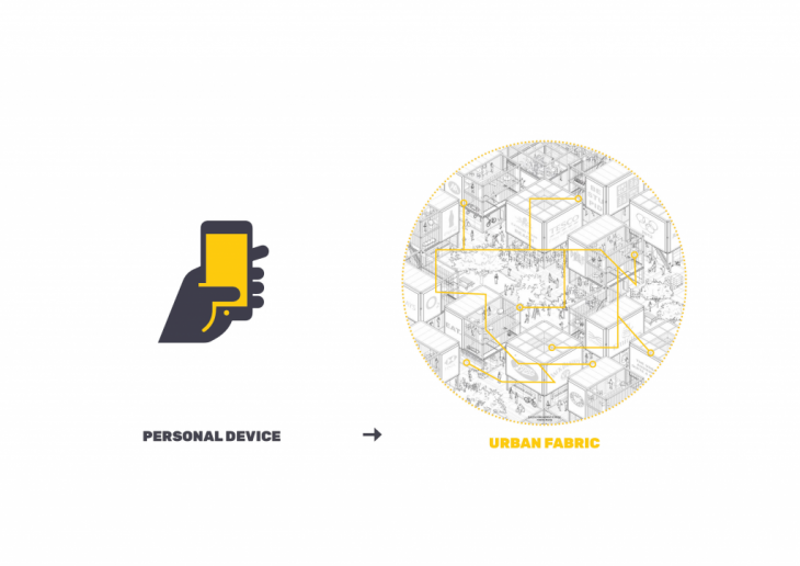
Our current interaction with emergent technology exist mostly with personal devices and displays which act basically as a barriers that limit our interaction with the real world. That is why the proposal for the project is to implement interactive surfaces into the city scale. Architecture, buildings and urbanism as a fabric of every day life represent a unique opportunity to interact with the users.
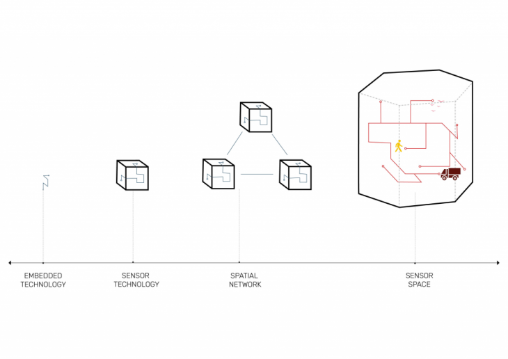
Micro controllers and chips create sensors that capture information. The spatial network of this system and implementation into the urban fabric gives an opportunity not only to capture the information but also response to the users of the space. So it means that sensors capture the information about users and according to their needs the physical space could be improved.
In context of Zona Franca the topic of mobility is significant, as being complicated space it contains absolutely different users which sometimes are mixed in one time. So using system of sensors, that was mentioned before, it will found the most relevant route for cars both to reach their destination, and also to avoid public space and interaction with people if it needs.
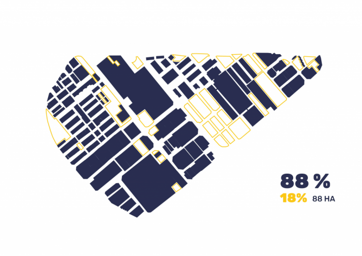
During the analysis it was figured out that the area of Zona Franca is quite dense and is not multifunctional.
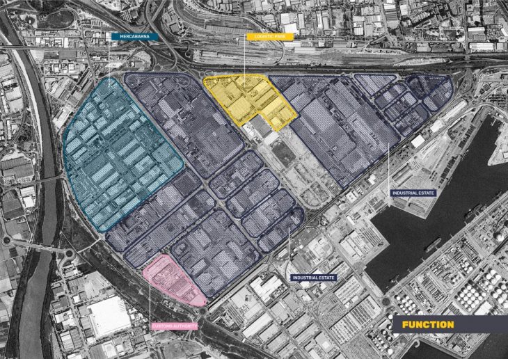
However it worth mentioning that it has a great potential to be developed and it need to have more functions such as housings, educations and public space.
 The area has 18% of unbuilt space, and what is more, relying on schedule the rest percentage of existing space is insufficiently used.
Most of the area is occupied in the morning: distribution of goods, the huge amount of trucks and workers create collapse, but afternoon atmosphere totally changes, it becomes empty and quite.
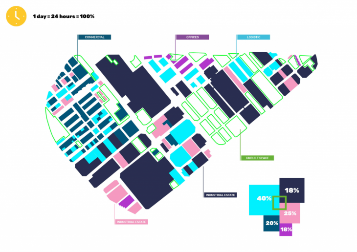
How space can be used during the rest of the day?
URBAN STRUCTURE = SCHEDULE
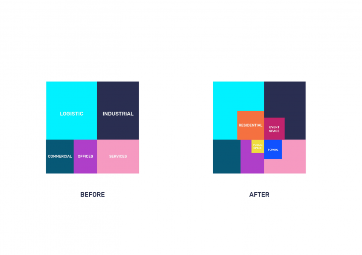
Relying on this analysis it was decided to reprogram the part of the territory instead of building new infrastructure. Reprogramming of the space is the kind of flexible system that can provide users with necessary functions at one time or another and also can be changed in a years.
What if space will have its own schedule for different users?
Urban tissue is a project of IaaC, Institute for AdvancedArchitecture of Catalonia developed at Master in City & Technology in (2018/2019) by:
Students: Polina Skorina, Maria Uporova
Faculty: Willy Müller, Jordi Vivaldi