Introduction
Today cities grow and change so fast that we, citizens, tend to lose connection with this transition especially in our immediate environments – our neighbourhoods.Urban Radar is a project that seeks to reconnect citizens with their local environment by activating programmes and influencing physical space through the most primary mean of mobility – walking. Set in downtown Shanghai, China, the research challenges the current process of urban evolution in such megacities, putting the citizen at the centre.
Shanghai
Ranked as the largest city in the world, Shanghai boasts of a population of more than 24 million people as of its last census in 2017.With increasing population rise, Shanghai plans for decentralization and polycentric spatial restructuring in order to alleviate the urban sprawl. In terms of connection and mobility through the city, Shanghai has the world’s largest rapid transit system by route length of 644 kilometres. It is the second largest by the number of stations with 393 stations on 16 lines.
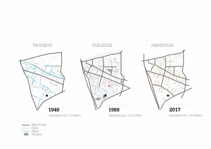
Reports from a study at Tongji university shows that the speed of development in Shanghai has robbed its residents of a collective memory of the places they inhabit, work and play. “The city grows too fast for us to keep up with.” An example of neighbourhoods highly affected by the city‘s speed of change is RedTown, located in downtown Shanghai in Hongqiao. In 2017, it was demolished to be redeveloped for the fourth time in the last 70 years, this time into a commercial complex. In a residential district in downtown Shanghai, what is the assurance that a commercial center would indeed be successful? Was the low stream of people in its previous states a response to the function of the establishment? Or does it have more to do with the neighborhood in which it was located?
This research ponders on what makes for active neighbourhoods, using Red Town, and its surrounding neighborhood as a reference. By examining the themes of activity in terms of program, and connection within neighborhoods, this project seeks to explore how neighborhoods can become more active by enhancing connection and programs within them.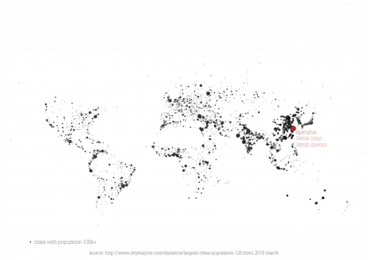
RedTown
This research ponders on what makes for active neighbourhoods, using Red Town, and its surrounding neighborhood as a reference. By examining the themes of activity in terms of program, and connection within neighborhoods, this project seeks to explore how neighborhoods can become more active by enhancing connection and programs within them. In order to assess the Red Town neighborhood as one that is active or not, it was analyzed based on available function and connectivity.
A 3km radius was created around the site forming the extent of further examination. This distance was chosen from studies that had shown that the extent of an average person’s desired walking distance was 3km, which is equivalent to approximately 30 minutes. For the purpose of the research, this distance and time span are regarded as the neighborhood.The types of activities found in a neighborhood give it character and could also make or break its sense of place. In the most livable areas, the public space forms the central part of the community, fostering a sense of belonging, engagement, and responsibility in the people. From analysis, a higher level of connection from Red Town towards the city center was identified, and less connection to activities towards the residential areas.
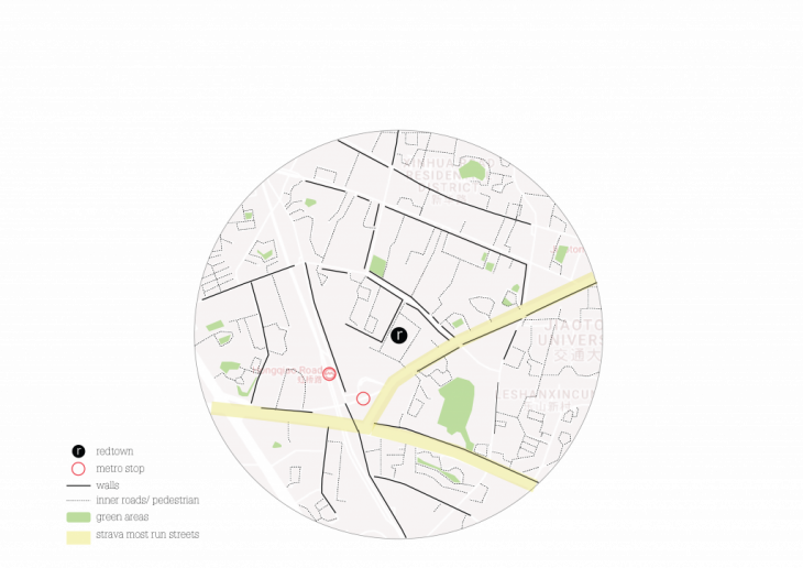
The relative ease of moving within a neighborhood signifies its level of connection. Walkability is often used to measure this ease, as it is the primary mode of mobility. Therefore, the more walkable a neighborhood is, the better connected it is. From observation, various barriers to walking are identified such as fences, poor pedestrian infrastructure sure as very narrow or non-existent sidewalks, highways and traffic. Although walking accounts for about 26% of the mobility modal share in Shanghai, examining the city on a smaller scale shows that walking might not be at its optimal level in the city.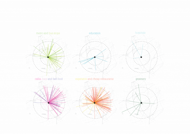
 Strategy
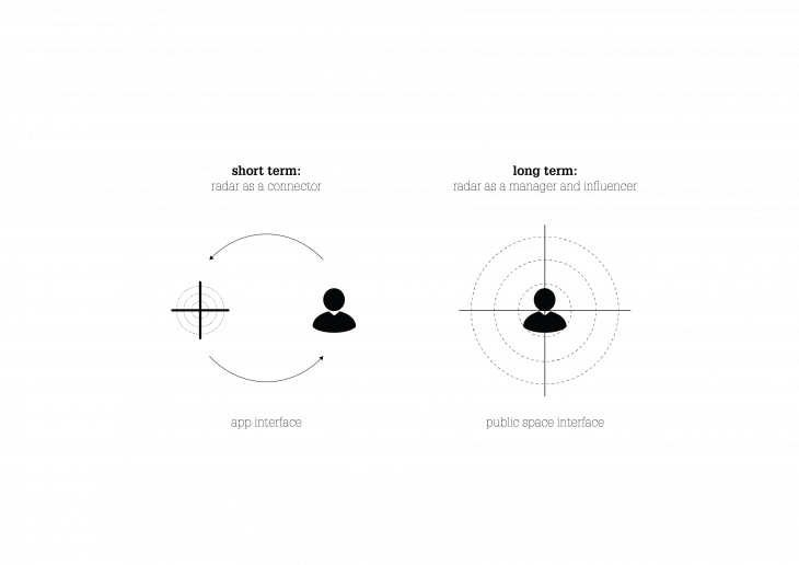
Urban radar is a system which helps to reconnect citizens with their neighborhoods. Based on the citizen in the center, walkability as the main form of connection, and local businesses as activity generators, Urban Radar is a powerful tool to reactivate our neighborhoods. It also aids in empowering citizens to identify physical gaps in public space, which helps local administration create faster and better solutions. Bringing the user to the center of the system changes the relationship with the neighborhood. It recognizes the user as an important participant in the outcome of the urban environment, allowing them to decide the extent of their personal neighborhood. The means of connection within the user’s radar is centered around walking, and other forms of sustainable transportation become plugins based on this primary form of mobility.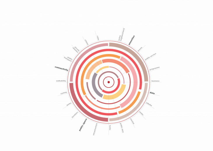 App interphase
The application consists of 4(four) key players and parts: data-in, user, local businesses, and public administration. Data is fed into the system from existing social and location intelligence platforms. The users, which consist of individuals and local businesses create the dynamics of supply and demand of programmes. The data that they create is collected by the public administration for the purpose of bringing about physical interventions or policies according to specific needs identified.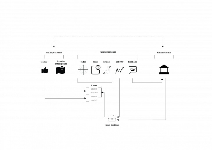 Local businesses are incentivized to advert using this platform in order to target potential customers according to chosen filtered interests. The government plays the role of regulator observing the dynamics in the different areas and facilitating change based on demand and supply. Through Urban Radar, they are better equipped to provide more focused, user-specific solutions and planning decisions. Through the use of artificial intelligence and internet of things, could the system eliminate public administration and even business owners, and respond directly to physical and activity demands of the people?
 Physical Interphase
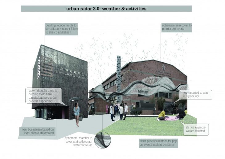
The project scales up as Urban Radar becomes a part of the physical space through future technologies and ephemeral architecture to create dynamic physical spaces that cater to the changing needs of the people. Hence a proposal for a public space transformation matrix based on factors that affect walkability, such as weather, activities, infrastructure, and transport. Each element conjures different responses in the public space based on its state.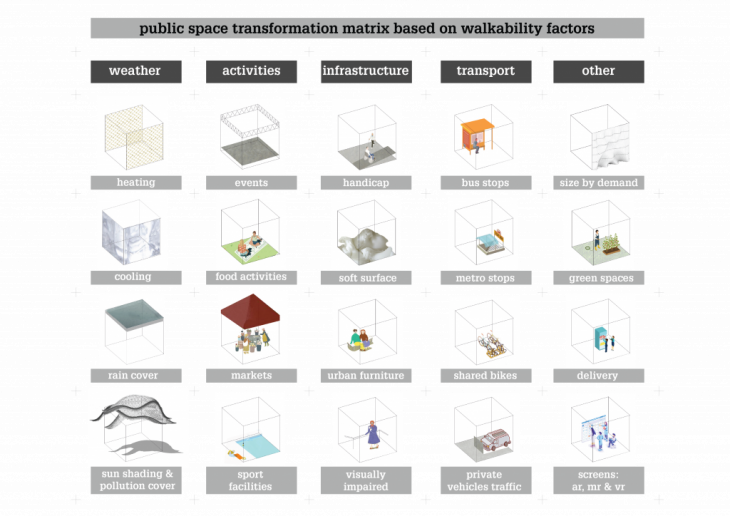
Although redevelopment plans for Red Town would go on as planned, this project challenges the effect of rapid development in regards to neighborhoods. It seeks to activate neighborhoods from within, by also fostering its livability.
 Urban Radar is a project that seeks to reconnect citizens with their local environment by activating programmes and influencing physical space through the most primary mean of mobility – walking.
</p>
URBAN RADAR is a project of IAAC, Institute for Advanced Architecture of Catalonia, developed at MaCT (Master in City & Technology),
2017-18 by:
Students: Camille Feghali , Saule Gabriele, and Venessa Williams
Faculty: Federico Parolotto, Kathrin DiPaola, Francesca Arcuri, Sebastiano Scacchetti, Julius Streifeneder, Alex Mademochoritis