ABSTRACT
The Sustainable Housing Intelligent Tool aims to help urban designers and decision-makers to develop walkable, energy-efficient, and social neighborhoods. This is achieved through a series of iterative computational generation that explores the best land-use and building geometry solutions for optimal environmental performance and livability.
INTRODUCTION
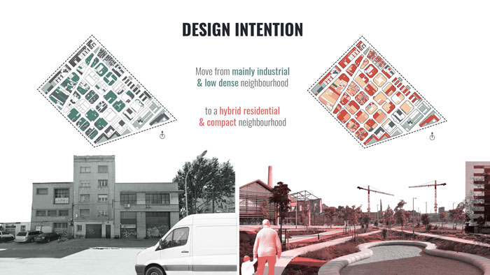
The selected site for this study is district 22@ in Poblenou, Barcelona. The area is characterized by low urban density due to the fact that the land use was historically industrial and has recently been going through an urban reform process aiming at regenerating and activating the entire district with residential, creative, and business activities.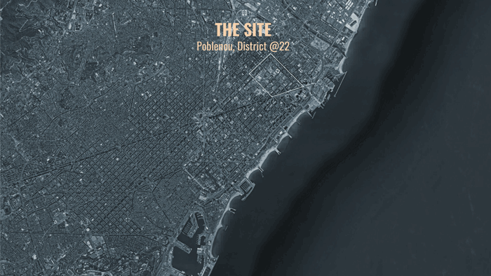
A Process of social participation has taken place in order to identify the best intervention in the area. The main takeaways were that the 22@ urban model with its typology of buildings (offices and hotels) does not allow a cohesive neighborhood development due to lack of residential density and prevents the development of everyday life.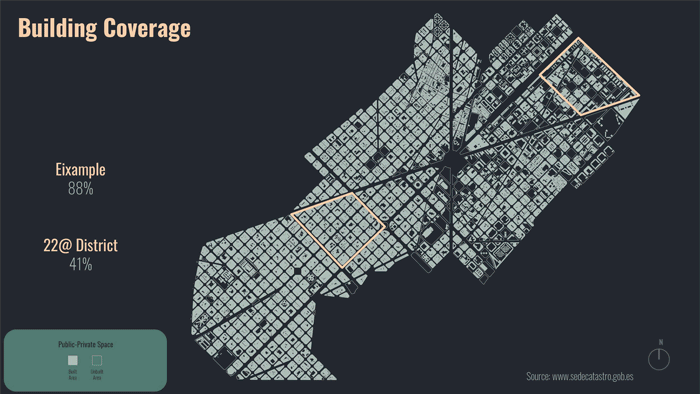
The tool is applied in a particular area located within the 22@district, between Gran Via de les Corts Catalanes, Avinguda Diagonal, Carrer de la Selva del Mar and Rambla del Prim. The site has a large proportion of vacant and industrial land which is a rarity in a city as dense as Barcelona. This provides a great opportunity for development and innovation in a well-balanced residential and commercial neighborhood, such as the Eixample district typologies.
CONCEPT
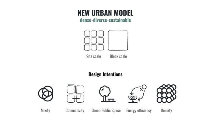
A new urban model for the 22@ district is desired: more dense, diverse, and sustainable. We want to transform a mainly industrial and low-density neighborhood into a new hybrid and compact one, applying the negative and positive insights learned from the Eixample typologies and development model.
Through the tool, we aim to achieve five main objectives: mixity, connectivity, energy efficiency, density, and maximize green public space.
Mixity. Create and manage land use diversity:
-Encourage non-automobile-based modes of travel such as walking and cycling.
-Establishing the number of potential destinations in a neighborhood.
Connectivity. Improve the user walkability experience:
-Create a more accessible urban environment.
-Improve the desirable paths within the neighborhood.
Energy efficiency. Drive the design through solar occlusion parameter to:
-Reduce energy consumption for heating and lighting.
-Improve wellbeing through exposure to natural light.
Density. Compact and connected urban environment:
-Strategy to reduce our carbon footprints and reverse the effects of climate change.
-Denser cities encourage shorter walking trips and complement the benefits of mixed land use.
Maximize green public space. Create a balance between private and public space:
-Public spaces as anchors for social interactions.
-Green areas to improve the quality of the neighborhood and increase contact with nature.
METHODOLOGY
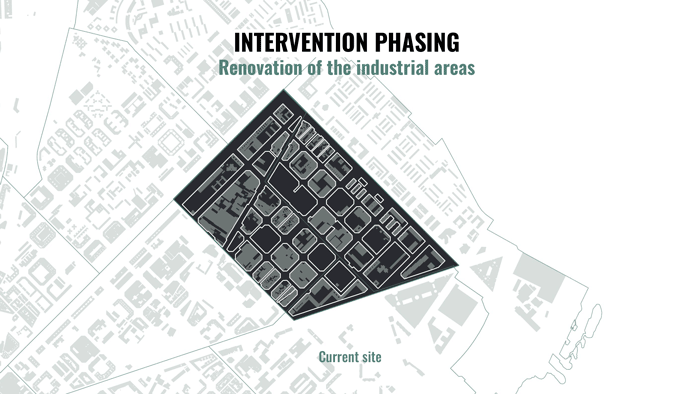
An intervention phasing is developed based on existing land uses in the site. Vacant land plots will be used as the first phase of generation. New land-uses and buildings will be generated in these plots first. The second phase of intervention will be to clear out some old industrial lands and re-purpose these plots for a better mix of uses in order to achieve the project objective set previously.
SIMULATION
The simulation is split into two parts, the land-use generation and the block aggregation. After generating the optimal land-use for the site, the user can select a block to generate a new building based on a number of modules.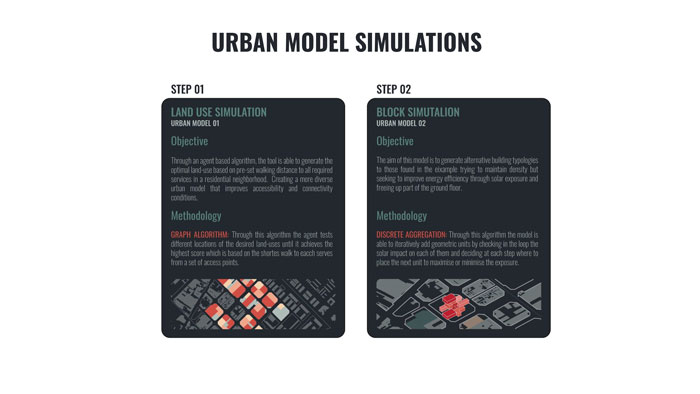
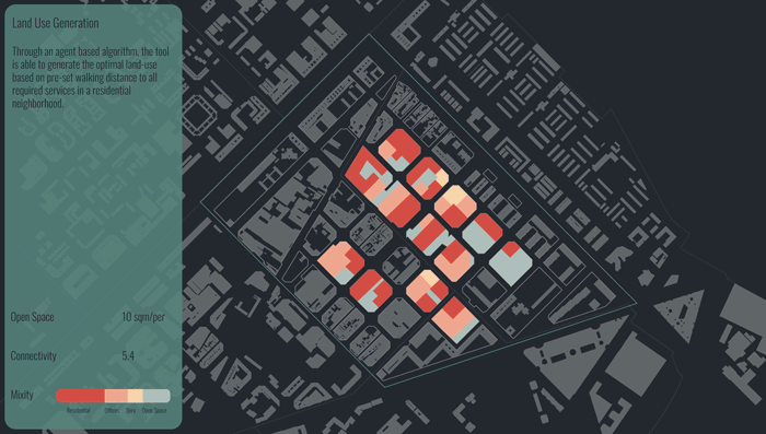
LAND-USE SIMULATION
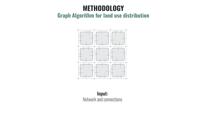
The land-use simulation is done through an agent-based algorithm. The tool is able to generate the optimal land use based on preset walking distance to all required services in a residential neighborhood, creating a new urban model that improves accessibility and connectivity conditions. The implementation of the algorithm is divided into 3 components: a graph network to modelize the city, a multi-agent system to simulate users, and an optimization algorithm.
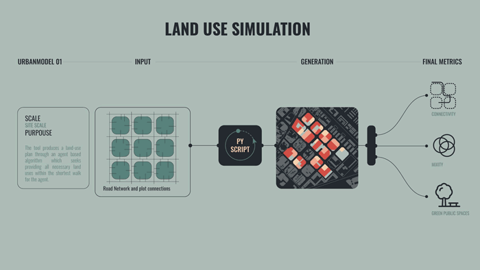
Firstly, the graph network is a data structure to represent the connections of the city. It is produced from the roads and buildings of the city (or studied district). A graph structure is made up of nodes and edges. In this algorithm, each building and crossing are represented as nodes which are linked by edges that represent streets and connections with buildings. Each edge contains the parameters of the function that interacts with the user.
Secondly, the multi-agent system represents simulated users as agents, which are defined by their dwellings and the type of amenities it wants to reach. All the paths between its dwelling and the amenities nodes are evaluated using Dijkstra algorithm, defining the best path as the one that minimizes the negative effects. The end of this part computes the final connectivity score of the current land use which is the sum of each user’s path score.
Lastly, the optimization algorithm creates multiple land-uses and finds the one that minimizes the connectivity score. The final land-use function is integrated into Grasshopper with a client-server architecture.
BLOCK SIMULATION
The block simulation relies on a discrete aggregation algorithm. It aims to generate alternative building typologies to those found in other fully developed areas in the original Plan Cerdá, like the Eixample. The aim is to maintain the same building density in the area (Floor Area Ratio), but seeking to free up part of the ground floor and maximize the solar exposure of each building, in opposition to the enclosed courtyard block model.
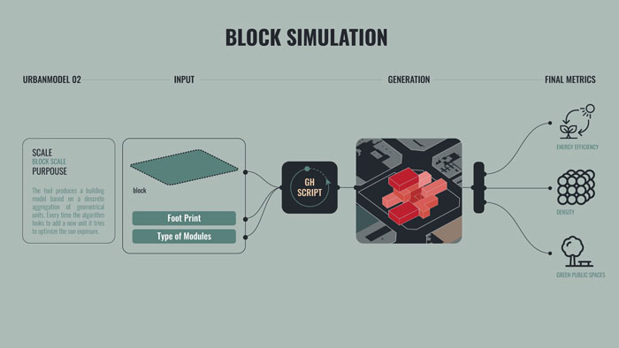
Firstly, two inputs need to be defined by the user to start running the simulation: the final building coverage ratio to achieve on each selected lot, determining the desired proportion of public and private space on the ground floor, and the type of modules to be used in the aggregation process. A catalog of modules is developed for each land use category, with different shapes, areas, and expected occupancy, from which each user can select the desired ones based on commercial parameters and singular requirements.
Once the maximum first-floor total area and types of modules are defined by the user, the model is able to iteratively add these modules by checking in the loop the solar impact on each of them and deciding at each step where to place the next unit to maximize the sun exposure. Every unit inside each module includes basic information necessary for the aggregation process, such as the final geometry and a set of possible connections location, and orientation.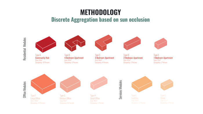
The rule to select the best option to orient one module over a selected connection of another one is based on the measurement of the shadow cast by each option over the rest of the modules already aggregated in the model. The selected option will be the one that casts the least shadow and receives the most solar radiation at the same time.

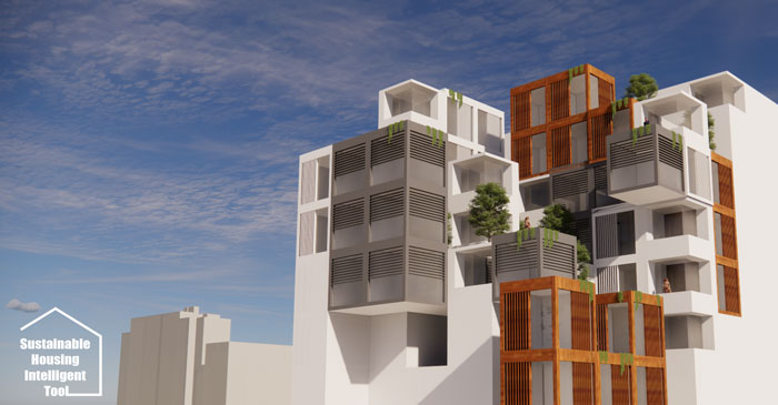
DEMONSTRATION
The user can test different inputs and modules until the preferred option is achieved. Every simulation is measured by three different metrics, that allow the user to compare all options and check how close the result is to the initial objectives of keeping a similar building density (Floor Area Ratio) of an Eixample typical block, but with a bigger public open space on the ground floor and a better overall sun exposure.
Density and Coverage metrics are extracted through the comparison of the sum of the built-up area of all the modules used with the original lot area. On the other hand, the solar radiation is measured by a Ladybug simulation to obtain the total number of kW/h received by each solution.
CONCLUSION
With the help of the discrete aggregation and the agent-based algorithm, we are able to explore hundreds of possibilities that would not otherwise be possible manually, experimenting with both form and materiality in each proposal.
While the model still requires development and aesthetic enhancement, it offers a great tool for designers to achieve optimal, environment and user-sensitive models achieving commercial requirements often set by clients or stakeholders at the same time.
Sustainable Housing is a project of IAAC, Institute for Advanced Architecture of Catalonia developed at Master in City & Technology in 2020/21 by students: Alvaro Cerezo, Iñigo Esteban, Leyla Saadi and Tugdual Sarazin and faculty: Alex Mademochoritis, Eugenio Bettuchi & Iacopo Neri