Introduction
“Rewilding” is a habitat conservation concept that increasingly draws attention to the public. However, the existing rewilding practices are often established upon binary views on ecosystems, such as isolating “artificial” from “the wild” or illustrating ecosystems as “services” to human “beneficiaries”(Deary and Warren 2018). We aim to challenge these binary views by inviting other species to co-managing the trial fields: In the “core area”, the autonomy of other species is respected; In the “buffer area”, humans’ capability in living friendly with other species is valued and emphasized.
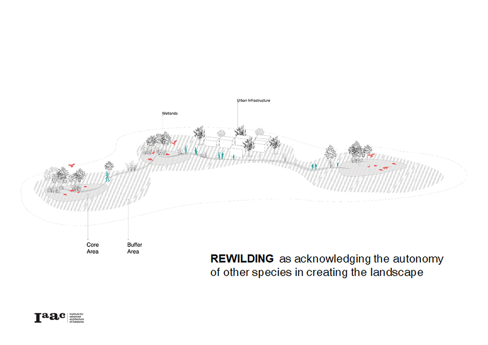
Trophic dynamics of core area (dominated by other species)/ buffer area (dominated by humans) in existing and proposed scenarios
Context & site selection
The challenge is taken in the Luxembourg context, where habitat fragmentation is a significant issue under urban sprawl and highway network expansion. Among natural habitats affected, wetland habitats are the most vulnerable ones. Therefore, we decide to focus on wetlands as our trial fields.
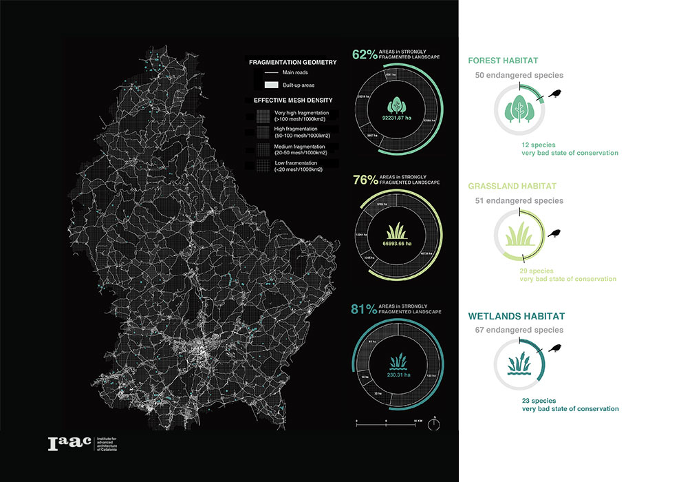
Wetland fragmentation map and habitat loss data in Luxembourg
Beavers as cross-species collaborators
We consider beavers (Castor fiber) as our cross-species collaborators to manage the trial fields. Widely known as “ecosystem engineers”, beavers create significant landscape change for their spontaneous dam building behaviour. Such creation also attracts diverse species to settle, which could restore a more stable trophic chain. We will either reintroduce or attract beavers from their existing settlements to our trial fields, with the help of Beaver Dam Analogue technique.
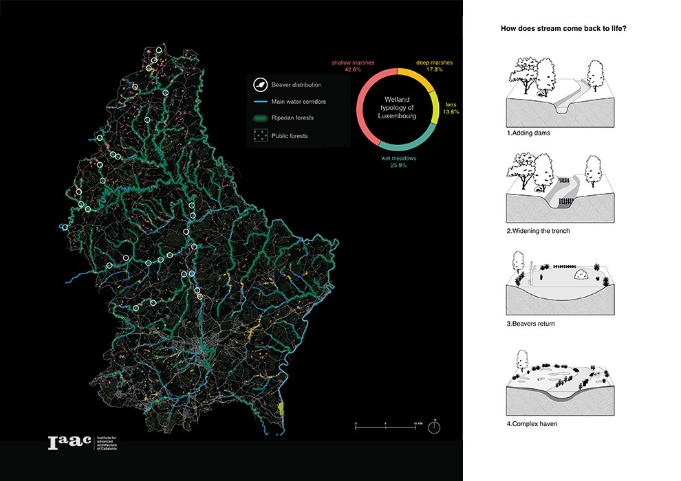
Existing beaver distribution and mechanism of Beaver Dam Analogues
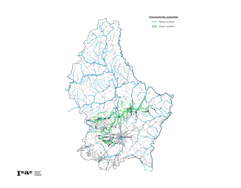
To determine the potential locations of these trial fields, we investigate the potential corridor for beavers and other wetland species. We firstly identify the protected wetland biotopes in order to cluster them. Then we run a Circuitscape simulation (Land cover as resistance map) based on these clusters as focal points.
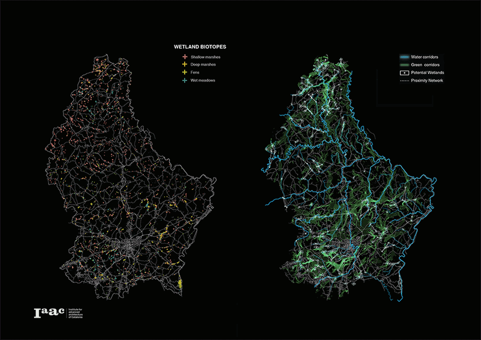
Process of simulating wetland connectivity map, area with significant green shows higher potential for beaver activities
Kids as human collaborators
Apart from beavers, we identify school kids in Luxembourg as our closest human collaborators. After the top-down initiation of our project, kids could stimulate bottom-up awareness by monitoring the whole process, as citizen scientists. Teachers are also encouraged to collaborate with other relevant parties, supporting kids and raising awareness. And once kids grow up, they themselves would be the advocates/decision makers for the new landscape they monitor and intervene.
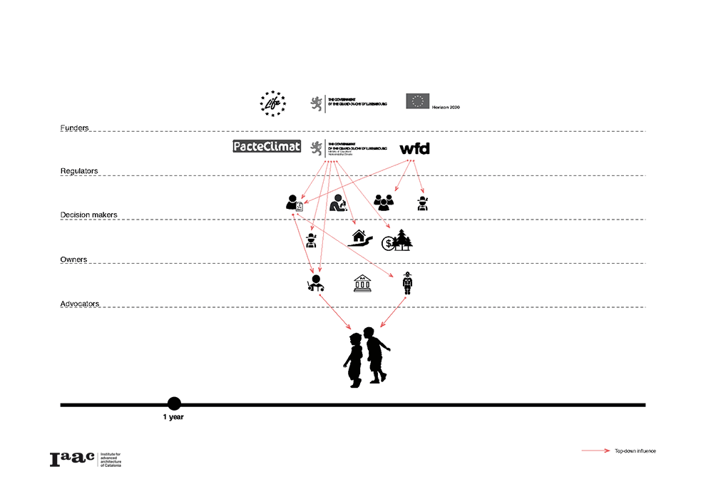
Dominant direction of influence through different types of stakeholders in project lifecycle
Based on the wetland corridors identified, we choose the pilot cities with the highest potential for cross-sector conversation. School kids in these cities have existing access to both science educators and wetlands, with nature protection partners providing support to other affected stakeholders.
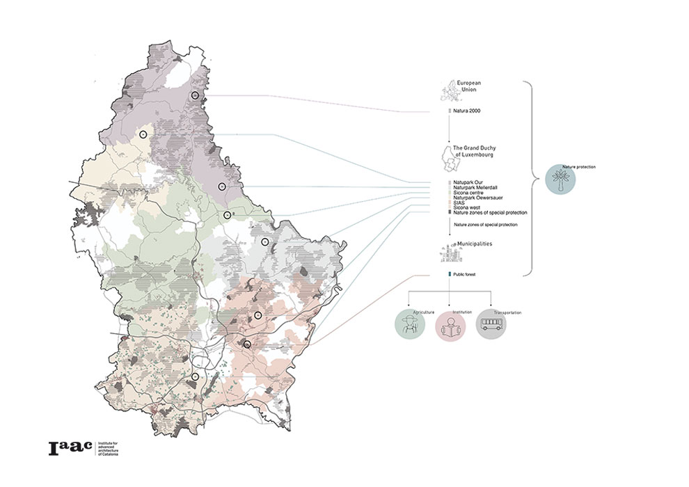
Luxembourg Stakeholder Map
Scaling down: Bertrange area
From the previous simulation, we decide to scale down to the main wetland connectivity corridor, crossing central Luxembourg, between most of the pilot cities from our stakeholder map. Among the cities along this corridor, we choose Bertrange municipality as an example for detailed analysis.
Location map of our pilot cities based on potential wetland corridors
In the Bertrange area we identified the main stakeholders to be involved in our proposal, among which teachers from education institutions, natural protection experts and land owners will be directly reached. In order to avoid severe conflict and at the same time increase the citizen’s awareness for our project, we allocate the trial fields at the periphery of Bertrange city along River Petrusee.
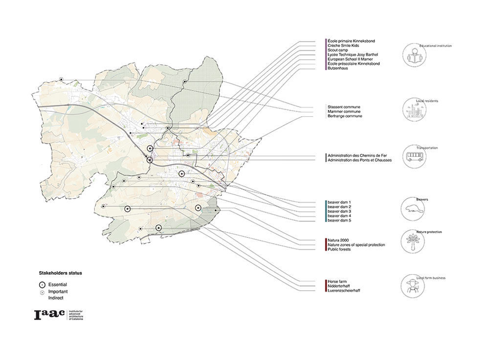
Bertrange Area Stakeholders Map
Proposal
In the core area of our intervention, lands are initially prepared by humans with Beaver Dam Analogs, tree protection and new plantations. These will then be changed and maintained solely by beavers and other wetland species.
In the buffer area of our intervention, lands are actively intervened and managed by the local community and land owners, mainly by guerilla gardening, creation of pocket wetlands, maintaining wildlife corridors and wildlife road crossing tunnels.
Along with these interventions, kids are invited to observe and monitor the data as little citizen scientists. We proposed an app to facilitate this process, which helps kids to see how the interventions evolve and how other species react to the interventions through time.
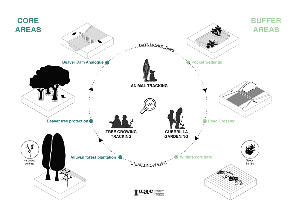
Catalogue of Interventions and App Interface
Bertrange area: analysis
Our first step was to identify the 7 educational facilities of Bertrange and their relation to wetlands locations.
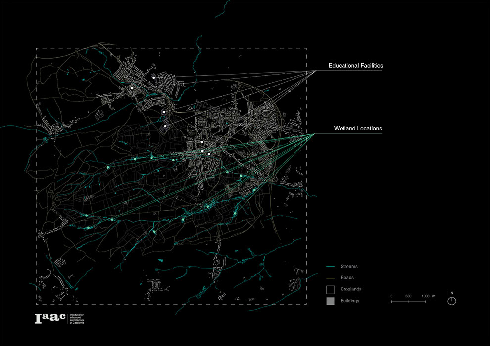
Educational Facilities and Wetland Locations in Bertrange
Human movement
Using Grasshopper, we extracted the shortest paths from each school to every wetland. The base network we used was the merge of existing road networks with the barriers of agricultural croplands of the area.
After, we filtered the paths by time and location so we extracted the paths that can be an 1h and a 2h walk from the 3 schools that are located in the city center.

Shortest paths between the 3 schools of Bertrange city center and each wetland location
Animal Movement
In order to extract the skeleton lines that show us the animal movement between the wetlands, we used Circuitscape Simulation. The network we used for animal paths are these skeleton lines, through the agricultural croplands so that we can identify how the animals will probably move through the territory.
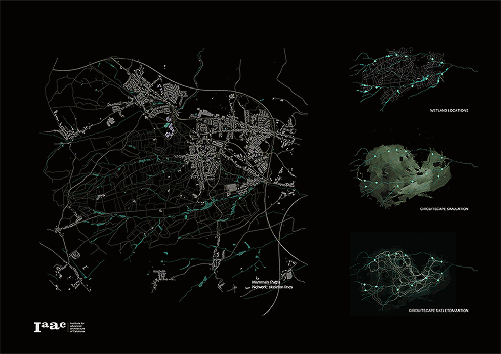
Circuitscape analysis and skeletonisation of the animal paths
Flood dynamics
Since we decided to work with beaver dams it is also important to understand the flood dynamics of the river. To achieve this, we ran the CAESAR simulations before and after putting Beaver Dam Analogues on DTM model. As a result, less flood flows into the city in both dry and wet seasons and more wet areas are created behind the Beaver Dam Analogues. To maximize the potential of morphological change by beavers and kids, we define the dry season flood threshold as the boundary of core areas, while the buffer area will cover the flood threshold of wet seasons.
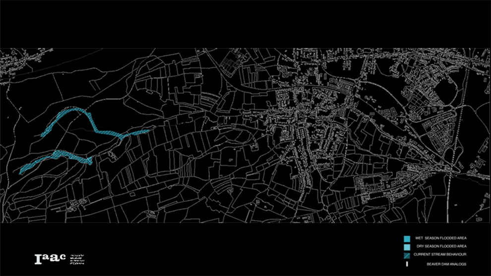
Ceasar Analysis of river Petrusse
Finally, combining all the previous elements, human and animal paths along with the flood limits we can identify in our area the position of our interventions.
When animal and human paths meet, we propose the allocation of pocket wetlands and the creation of wildlife corridors, whereas along the river in the new dams locations, the tree protection and the planting of new trees that beavers prefer; at the intersection of roads with animal paths, we propose wildlife road crossing tunnels.
At all these intervention points, the observation and the monitoring of data will be done by kids with the help of our app.
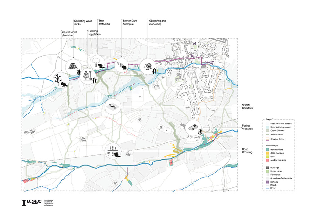
Mapping the interventions
Rewilding Luxembourg: A storyline
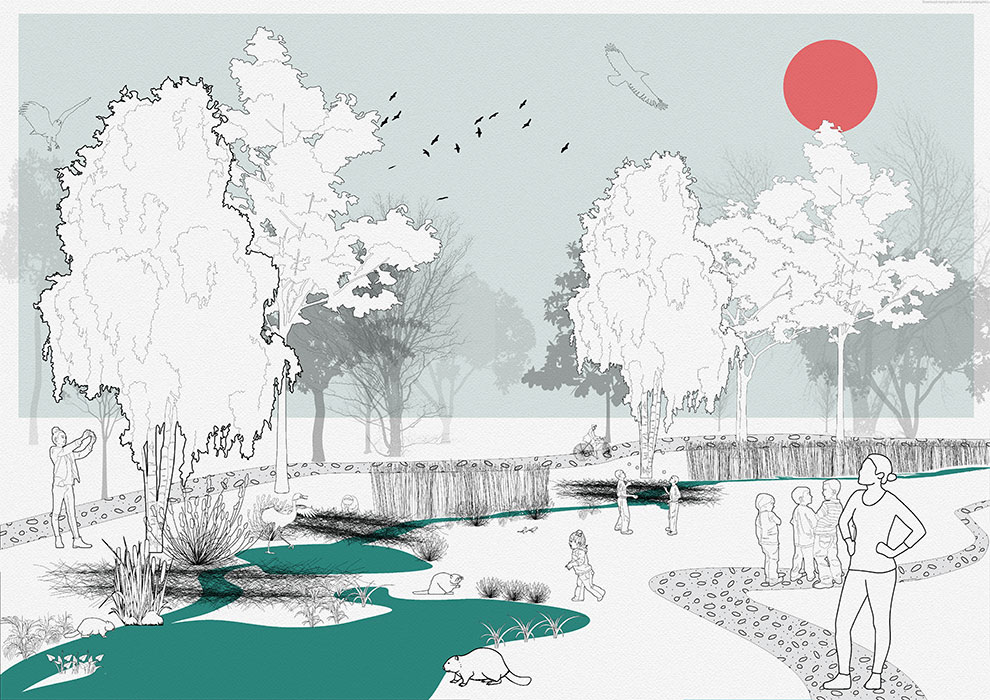
We will explain how these interventions could take place through a story from Helena, a science teacher in a primary school in Bertrange. When our project initiated, Helena volunteered with other conservation workers to establish beaver dam analogues and plant trees to support beavers. In a new term next year, when beavers settle in the core area, Helena leads her pupils to the trial wetland. She provides them with seed bombs of beaver’s favorite herbs, and asks her pupil: “How could you invite beavers to our garden with these seed bombs?” She also introduced the use of our app, and asked pupils to record their interventions. Each week Helena leads her pupils to the wetland observation spots on the buffer zone. She collaborates with conservation experts to help kids scientifically record beavers’ behavior and changes of their interventions. Other visitors to these observation spots are also invited to report species occurrence by time and location. With the help of different eyes looking at the wetlands, both Helena and her pupils could get a better image of wildlife behaviors between their creation, and beaver’s creation on land.

Stage 1: After one year of preparation, beavers are reintroduced to the site, creating a complex wetland matrix that inundates part of the adjacent buffer zone | Stage 2: Kids can plant in the wet experimental field the seed bombs wherever they want, while their access is restricted to the core area by notice and a row of plantings. | Stage 3: The observation spots used as key thresholds for kids and visitors to observe changes in the core zone, whereas camera trapping provides better monitoring on buffer zone.
Conclusion
We would like to conclude with our vision, where beavers in Luxembourg does not simply appear in isolated reserves, but are actively engaged in changing the landscape of human society. With the adaptive intervention and monitoring from kids and local communities, we believe a more tolerant, non-binary coexistence could take place, with the human society been “rewilded”.
Rewilding Luxembourg is a project of IAAC, Institute of Advanced Architecture of Catalonia developed at Master in City and Technology in 2020/21 by students: Alvaro Cerezo Carrizo, Arina Novikova, Dongxuan Zhu and Stefania-Maria Kousoula and faculty: Eduardo Rico, Mathilde Marengo and Iacopo Neri