Parasitic Houses Generator.
ABSTRACT.
Parasitic Houses Generator. Accessibility to housing for low to moderate income groups in Barcelona has experienced a severe decline caused by massive tourism. On the supply side, the public sector has made some efforts to make affordable housing available to its citizens. Today, around 55 percent of the world’s population is thought to be living in an urban area or city, with that figure set to rise to 68 percent over the coming decades, according to the “Population Division” report from the United Nations Department of Economic and Social Affairs. The statement puts Barcelona at a greater risk for housing shortage, let alone affordable housing. When the role of government is once again seen as vital in funding and providing affordable housing for everyone, it becomes ever more important to have a better strategy by city councils to address the issue using advanced technology available.
This project aims to algorithmically create an affordable housing plan for Barcelona, specifically in the innovation area, the 22@ Poblenou. The area consists of 28 typical barcelona blocks. It attempts to leverage the temporality and cost efficient construction of housing through parasitic architecture. Using data sources that give us discrete information regarding the building characteristics and nearby accessible services in order to provide parameters of which the user can morph the parasites appropriately to their desired hosts. This tool would be used by the city council, as a way for them to select the buildings of which they would like to add parasites to and note the mathematical impacts of certain Key Performance Indicators (KPIs) that are crucial in understanding the impact of such a plan. Furthermore we outline our methodology in 4 different key elements: Data Sources, Parameters, User Decisions, and Impact KPIs.
INTRODUCTION.
- Importance of adequate housing for every citizen
Rapid urbanisation as well as demographic and technological changes are among the trends reshaping the cities in which we live, work and play. In many places this trend towards rapid urbanization goes hand in hand with the creation of more slums, more people in inadequate living conditions and lacking secure tenure of their housing and land, and greater disparities, inequalities and discrimination. These problems in turn threaten not just financial market stability, but also quality of life and integration, as well as city competitiveness on the national and international scale.
In Barcelona, a new quick-build model of quality sustainable temporary flats has been conceived to tackle the problem of local residents being driven out of their neighbourhoods. The right to access decent housing is a right recognised by law and the authorities at several levels: local, regional, national and international. The new Barcelona Right to Housing Plan (PDHB, in its Catalan acronym) aims to guarantee this right and provides for a 10-year period, from 2016 to 2025.
- The state of housing in Barcelona
Currently, Barcelona has a social rental housing (HPO) stock of about 70,000 flats or approximately 10% of the total housing stock. Of this total housing stock, 30% are empty rental properties, making it one of the Spanish cities with the most number of unoccupied properties. Despite this, the property sector noted this rental stock does not cover the demand. At the same time, average lease in 2017 increased by 9.48% according to the Cambra de la Propietat Urbana de Barcelona.
- Why do we need tools to distribute affordable housing?
At a time when public services face fundamental challenges, technology and digital tools and approaches are central to achieving all of this. One of the advantages of utilizing technology in city planning and management is in terms of the effectiveness and accuracy of all decisions made by the city council. In this case, using such technology would enable officials to have better decisions on where to distribute parasitic housing, while complying to existing guidelines. On the other hand this tool can help to make sure of the positive impact, track progress and analyze the effects of implemented projects and policies. Urban performance measures help communities make informed decisions and measure results against goals.
METHODOLOGY.

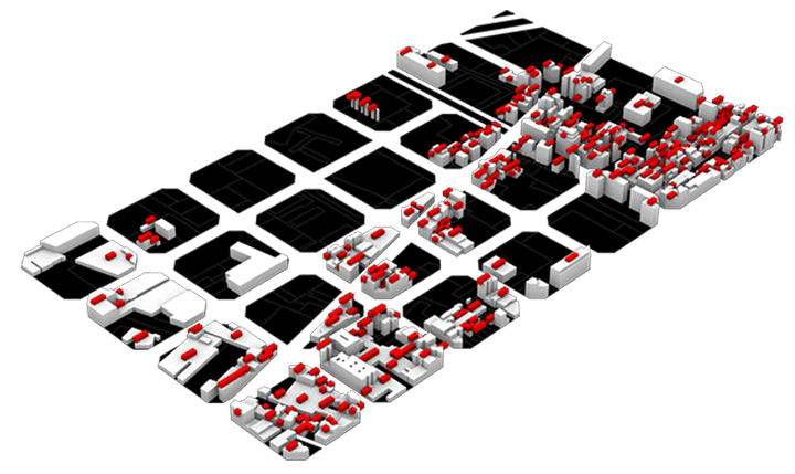
- Study area. The area that was used for this simulation is located in the 22@ of Poblenou, Barcelona. Particularly taking 28 buildings of the typical quadrangular blocks. 22@ is a clustering approach by the city government of Barcelona to merge universities, companies, and tech start-ups to spur creativity and innovation resulting from placing the institutions close together. The study area consisted of different building typologies such as residential, commercial, offices, industrial, and government buildings. The diverse characteristic of the study area is ideal to make urban simulation, as the more diverse the environment, the better it can represent other areas if we were to apply the simulation to any other locations.
- Data collection. First approach of data gathering was collecting basic information about the 28 building blocks through cadastral data that was obtained from Barcelona open data source, OpenDataBCN. The cadastral data includes information such as building height, building year (of construction), and building use. In order to get the geo-located points of commercial and services in the area we obtained the points from OpenStreetMap which also includes data about building floor numbers, and for some buildings, data about roof area. The aforementioned datasets are the basic inputs needed to create metadata for the layers used in order to filter the building blocks. Furthermore, to obtain some other information to feed this tool, grasshopper was used to generate analysis of walking distance between points which later then used for optimization analysis.
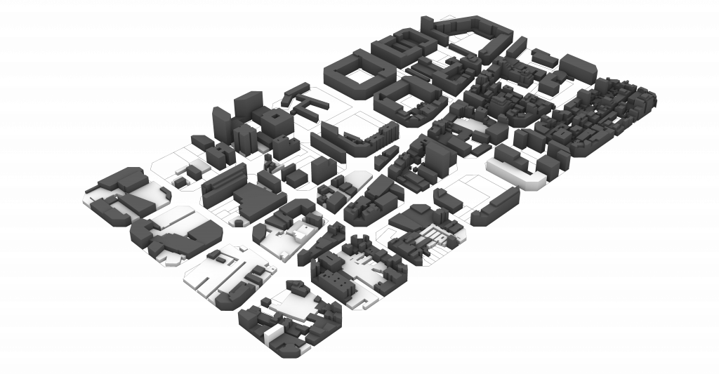
- Simulation. After the data collecting process, we used various simulation tools to achieve parasitic housing simulation. First step was to visualize the building typologies through grasshopper script, by connecting cadastral dataset with the 3D blocks in rhino. This helps us to understand the landscape of the site area better, especially when the project is to add more housing typology in an industrial area. The agglomeration of housing modules/cells was simulated using wasp plugin in grasshopper to create modular aggregation of the so called parasite housings. We then created a ruleset for the module to fit certain scenarios. After predefining parametric parameters, HumanUI plugin was used to create an interactive user interface for the user, to both visualize the output and tweak the input to create desired design.
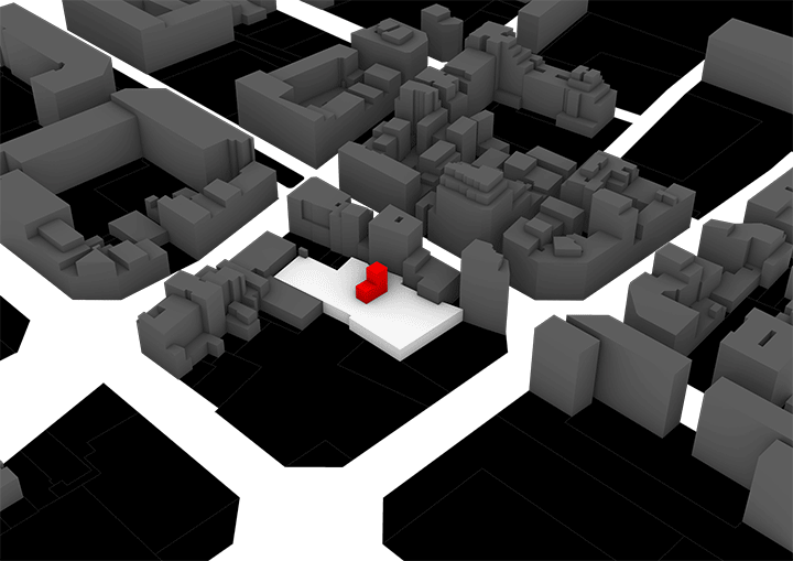
- Generating parasitic architecture. When adding new infrastructure to a city, the first thing that should be considered is the local building regulations of the site. Therefore, the interface will include changeable inputs that are necessary to follow the local regulations while also meeting demands. The interface will respond to queries from user inputs such as building typology, preferred height, year of construction, roof area, and also accessibility to services. After the parasites are simulated, a list of parasite modules will appear to select which of the modules is the best performing.
- Impact analysis. The intended outcome of this tool is for the user (city council) to be able to accurately measure how much housing is needed, and how to evenly distribute them to potentially generate economic gains. The impact is measured in two main perspectives; housing and economics. By injecting supply towards housing demand, the already high priced rent can be reduced, thus this will also help scale down gentrification. On the economic side, evenly distributed mixed use buildings will generate an environment where a neighborhood has services and facilities all within walking distance.
INPUTS AND PARAMETERS.
- Building use (land use). Land use data reveals the general distribution of existing functions and the proximity to destinations or community-serving facilities within the area. Land use diversity is a key component of compact livable communities where everything is within reasonable distances. This observation is helpful for establishing the number of potential destinations in a neighborhood and for drawing a more general conclusion on walkability. While public spaces and local centers act as anchors that allow people to meet and socialize, housing is the key to population density that actually brings people together. Without the aid of these tools and methodology the process for determining compliance with city regulations can take months and testing individual designs can be time consuming. Instead it only took us two weeks to determine the range of complying options and set us up to be able to quickly analyze future design options.
- Building year (of construction). This parameter becomes important when infrastructure development, especially on where affordable housing should be built, must be proportional. Old buildings can be refurbished to a new building as the result of having to host parasite housing. The age of the building can also give restriction information on how much the host can take new structure for example.
- Building height. Poblenou has certain restrictions on the number of floors allowed to be built, how high can a structure be, to maintain safety and the look of a city. Height restriction laws sometimes become a point of contention in cities due to their use in regulating the growth of the housing supply. Fast growth of housing supply benefits renters by producing low prices and more choice, while slow or no growth in housing supply benefits property owners by allowing them to charge higher prices.
- Roof area. In this case, roof area means the ‘land’ area or platform where the parasitic housing can be constructed. For the host, this parameter tells how much would they give to allocate some of their roof area to be spared for parasitic housing.
- Accessibility Radius. Access to transit within walking distances of places where people live and work is crucial for maintaining the economic vitality and quality of life in cities.
IMPACTS & KEY PERFORMANCE INDICATORS (KPI).
In order for urban planners to understand the effect of such a plan, they need to be able to understand the impact by developing predictive models. We split up our KPIs into two different key categories; housing and economics. For housing, the first thing we wanted to visualize to the user was a clear statement for how many units they are building and for how many tenants would live in these parasitic dwellings. Assuming the fact that these units could house around 1.5 people per unit, we simply multiplied the number of units by 1.5 to get the number of tenants.
Estimating the number of tenants allows us to estimate the new population density, which is next. For population density, since we know the current population of the site, we simply add the new number of parasitic tenants on top of this current population to get the new population. Then we divide this new population number by the square meters of the area to get the population density per m2.
The final KPI that we wanted to predict was the average rent cost for the site. Using the fact that affordable units in Barcelona cost around 400-600 euros for monthly rent, we took the median of this range and assumed each unit would cost 500 euros. Then, since we know the average rent for the site, we can ascertain the new average rent based on multiplying this 500 euros by the number of parasitic units. Number of tenants, population density, and cost of monthly rent for the site provides us key KPIs to justify such a project from a city perspective. To further develop these metrics, we could develop a correlation between the construction cost and the average monthly rent. Additionally, we could mature the assumptions of the population changes as well.
For the economic KPIs, we zeroed in on two key KPIs: commercial density and urban entropy. This is due to the fact that when you add more tenants to an area, this innately changes the urban space due to consumer demand, hence the commercial outlook is different. For the commercial density, we leveraged data that gave us a commercial density for each neighborhood in Barcelona. We then normalized this number and developed a linear regression with the population density of these neighborhoods. Once we had this linear regression formula, we were able to assess the commercial density in a score of 0-1 for both the current state and proposed state of the simulation since we know the current and proposed population densities.
The next KPI that we tackled was the urban entropy of the area. We took this idea from the Morphocode Explorer tool
https://explorer.morphocode.com/map
Urban entropy measures the mixity of the land uses for a specific area, in a score of 0-1. The details of how they calculate this in this reference are vague, so we made some assumptions in order to calculate it for the simulation. In order to calculate this, we first need to develop the land use distributions for the area. One assumption we made here is that since parasitic architecture is simply adding onto an existing building with a certain land use, the actual act of adding the parasites doesn’t change the building to a residential land use. However, the increase in population does increase commercial activities as we’ve explained for commercial density. Therefore, we assumed a change in the commercial land uses, which itself changes the distribution of the other land uses (residential, industrial, other).
Taking this new distribution, we needed a way to compare it to some ideal land use. This is where we made another assumption, that the ideal land use is 55% residential, 25% commercial, 10% industrial, and 10% other. Taking the absolute value of the differences of the new distribution with the ideal distribution and then subtracting that sum from 1 gives us the urban entropy score from 0 to 1. While these commercial KPIs are interesting to see the indirect effect of adding a population to a site, they can be developed further by researching further into the assumptions and adding additional commercially dependent variables.
Parasitic Houses Generator is a project of IaaC, Institute for Advanced Architecture of Catalonia developed at Master in City & Technology in (2019/2020) by: Students: Byron Cadena, Aryo Dhaneswara, Andrew Saltzman. Faculty: Alex Mademochoritis, Eugenio Bettuchi, Rodrigo Aguirre, Iacopo Neri.