Introduction
If time is important in order to enjoy leisure activities, it is also relevant to the availability of diverse and enough spaces for everybody. The provision of public space represents the means of the Public Administration to provide the opportunity to everybody to enjoy free time. In the last few years, the improvement of public space has been on the agenda of many cities as a way not only to improve quality of life but also to rebalance the relationship between places pacified and places for cars.
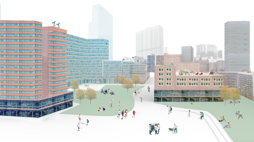
The current tool aims to explore the potential activation of new public space areas in the 22@ considering the relationship between the potential new public space and future newly built areas.
Context
With an existing population density ranging from 16,000 people/km2 to 50,000 people/km2, Barcelona is predicted to accommodate 4% more population in the next 10 years (United Nations, 2018). This future scenario requires solutions that can provide quality public space for the current and future population.
The topic of public space is a topic being tackled by many cities globally due to its relationship with many urban challenges: mobility, air quality, liveability, wellbeing, urban regeneration, community participation, and placemaking… Public space is a common element to integrate and link different urban solutions.
The city of Barcelona is also following and promoting innovative public space design and uses. Among them, the following project can be highlighted:
- Plan for Play in Barcelona’s Public Spaces: looking to move from a city with play areas to a playable city by 2030.
- Comprehensive redevelopment of public spaces: foresees improvement in public roads with works in 65 streets and 13 parks in all districts.
- Barcelona climate emergency declaration: seven model changes to become carbon neutral by 2050 and reduce greenhouse gas emissions by 50% by 2030 compared to the levels in 1992.
- Barcelona Superblock: Plan to establish a network of green axes and squares, with priority for pedestrians in the entire city.
Methodology
The site
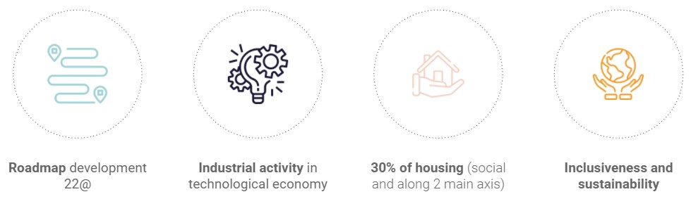
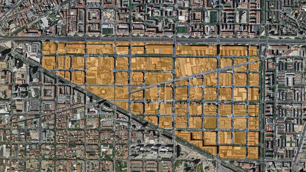
The selected site for the deployment of the tool has been the north area of the 22@ Innovation District of Barcelona. The development of this area is a priority for the City Council with the aim to tackle 2 main issues:
- Offer a competitive economic area within the city, complementing the southern part of the 22@ that has been already largely developed but is still offering plots for new opportunities.
- Provide new affordable housing units, reducing the unaffordability and the gentrification process experienced in some parts of the city.
Reasons for choosing the 22@ North
The site is limited by the streets of Diagonal, Gran Via, and Rambla de Prim and the intervention area will be the specific blocks of the 22@ project. The rest of the area has been included in order to keep the results contextualized and better integrated with the current built environment.
The site
The data
The main data utilize in the project is linked to the different shapefiles utilized and the rules settled for the development of the area:
- Blocks: data regarding total areas and populations and commercial densities
- Parcels: Information about the heights of the building (indirect information about the blocks that have not yet been developed.
- Uses: mainly related to the presence of parks and other green areas
- Rules: specifically the proportion of areas for each specific use (residential or office areas)
The models
Cellular automata: The system used to structure the tool has been cellular automata. This system is based on a network of cells that interact with each other. Each cell has a state and this state evolves over time depending on its neighbours. The selection of iterations generates different patterns that represent the basis for the development of the project.
Isovist: On the other side, the component of isovist has been used in order to assess the generated scenarios. In fact, considering the variability of generated spaced at the ground floor, the openness of the public spaces can be determinant in the allocation of leisure uses (amenities, spaces, shaded spaces.
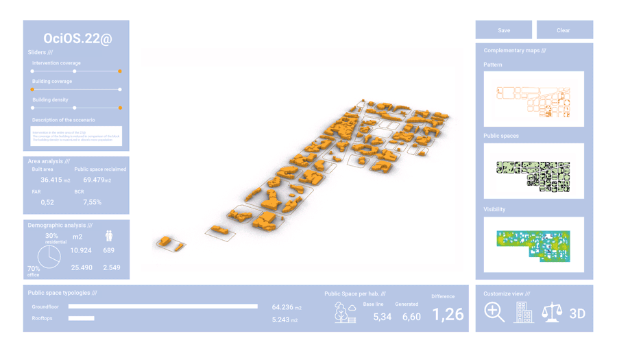
The tool: OciOS.22@
OciOS.22@ is a tool designed for city planners, city council and developers to be able to simulate different distribution of spaces in finding balance between public spaces and built areas at different levels within the northern part of the 22@.
The name of the tool is based on the work leisure in Spanish (“ocio”) and Catalan (oci), adding OS meaning “open space” and concluding with the code that represents the area of intervention. Moving the three sliders available, different scenarios will be generated.
User interface
The three main elements of the simulator are:
- The calculations
The scope of the tool was to simulate the relationship between the public space and the built area. To maintain the consistency of the tool and its potential value, the entire calculations are following specific rules and based on the output of the cellular automata. As explained and considering the large number of combinations that can generate a large number of scenarios, only a few combinations have been presented in order to show the potentiality of the tool.
- The 3D model
The 3D model is the final output of the simulations. It considers both the real 3D model of the site, extruding the heights of each parcel, and the generated 3D model. Beyond the design of each building, the main focus was given on the generated space and the relevance of the potential urban rooftops.
- The Complementary maps
The UI offers complementary information for the assessment of each scenario. Out of the three maps, the first one is the raw pattern generated by cellular automata, the second one only shows the public space, both at ground level and rooftops and finally, this one shows the visibility of each area at the ground floor. This last one is particularly relevant since uses isovist to assess the impact of the automata, showing the importance of combining two different models for designing and assessing.
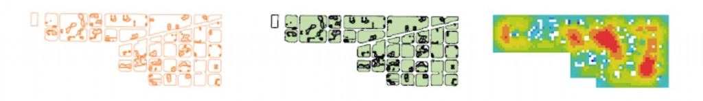
Complimentary maps: patterns, public spaces, visibility
Video
Results and final remarks
The results obtained in each scenario are showing how the residential and working population is evolving according to the distribution of the built area. Considering the goal of Barcelona City Council of increasing the available public space per inhabitant by 1 m2, the tool simulates the reaching of this goal, from a minimum increment of 0m2 to a maximum of 1.53 m2.
Considering the lack of housing and the need for further office spaces, the different scenarios manage to give inputs regarding the distribution of space. Depending on the developer’s needs and sensibility, as well as the priorities or constraints settled by the Barcelona City Council, it is a matter of defining them and seeing the outcomes of the tool.
OciOS.22@ Leisure Open Spaces Reclamation is a project of IAAC, Institute for Advanced Architecture of Catalonia developed at Master in City & Technology in 2020/21 by students: Riccardo Palazzolo Henkes, Kshama Patil, Dongxuan Zhu, and Sasan Bahrami and faculty: Eugenio Bettuchi, Iacopo Neri and Alex Mademochoritis.