Introduction
The following project aims to study the creation of a green corridor for pollinators in a specific area of El Vallès plain, near Barcelona, using the existing abandoned crops as structural elements to improve the ecological connection between the North and the South of this region.
The concept of rewilding guided the development of the project. It refers to an action at the landscape level that has the goal to reduce human control and allow ecological and evolutionary processes to reassert themselves. In particular cases the final intention includes also the reintroduction of keystone species.
The field of action in this challenge is very fragile, therefore the interventions have to be careful and controlled, in order to maintain the balance between humans and nature. This project represents also a valid occasion to better understand the relationship and the significant difference between the natural and the anthropogenic ecosystems.
In fact, in the natural ecosystem the circle of matter and energy flows perfectly. Everything is in balance and is part of a fully functional mechanism. Instead, on the other hand, the incapability of man to be self-sufficient or sustainable is quite prominent, and this is testified by his attitude with things that he deems no longer useful, like for example abandoned crops.
In this project we tried to take advantage from this problem, translating it in an opportunity for rewilding. In fact, the state of abandonment of these lands is considered the best to enable a rewilding process, and their exploitation in order to obtain ecosystem services is the idea at the basis of the project. Through abandoned crops and ecosystem services we propose to close the circle and create a new circuit where the two ecosystems work together.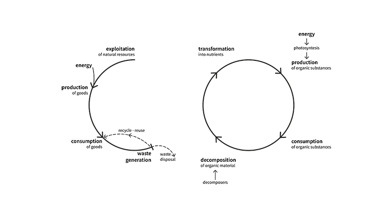 We decided to focus our attention on pollination, an ecosystem service elemental for our survival. Pollution, pesticides in agriculture and the different land uses among others are the main risks related to their existence, and insects, that are the most common and known species that provide this service, are the most threatened. So, for these reasons we decided to enhance their specific habitat.
We set our interventions in El Vallès plain, where the number of abandoned crops increased during last years and thanks to its singular characteristics proved to be a very interesting territory. It is a densely inhabited territory, where cities are separated by large cultivations and industrial districts, all entirely surrounded by highlands, that are wide protected natural areas.
All these features have rendered this site an exemplary and exciting case study because it contains all the elements we wanted to consider in our challenge and that makes El Vallès a clear example of co-existence between the natural and the anthropogenic ecosystem.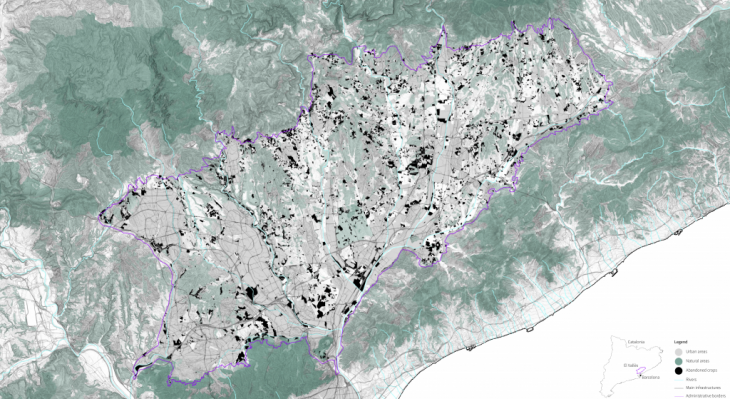
Methodology
Methodology
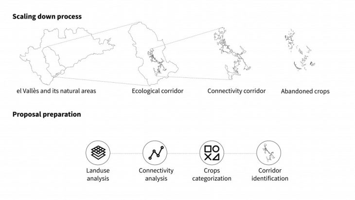
With the aim to identify the ecological corridor in the landscape, the methodology is based on a scale-down process. The process starts from the land use analysis, it continues with the generation of a connectivity map and with the categorization of the abandoned crops and it concludes with the identification of the ecological corridor.
Designing the corridor for pollinators
For the design of the corridor, it has been analyzed the ecological performance of the area of study, assigning different resistance to each land use: from the lowest resistance of natural areas to the maximum resistance to urban and industrial areas. In order to identify the areas with a potential higher connectivity, the resistance of abandoned crops has been modified from one of the current situations to a new low one, similar to the ones of natural areas.
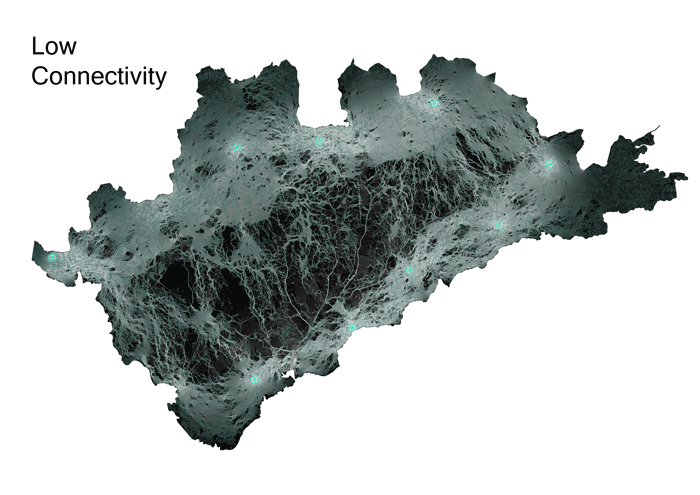
Connectivity simulations – Large scale
This process allowed us to see new connections and new intensities, helping us to identify an interesting area with high potential connectivity. Scaling down into this area, we undertook and new simulation in order to identify the new connections and linking them with the abandoned crops. Considering the connectivity map and their relation with the abandoned crops it was possible to assign to each of these crops an intensity level.
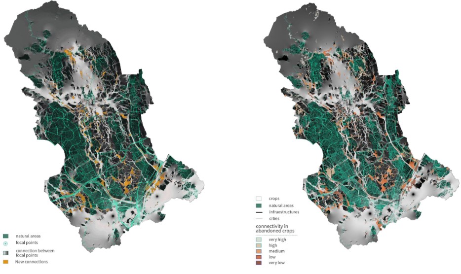
New connections and intensity – Small scale
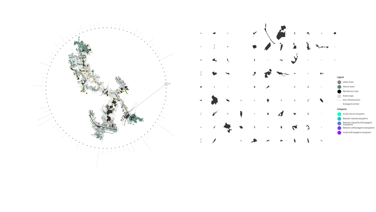
The preliminary analyses of the land-use have led us to identify multiple habitats, which have been classified based on natural or anthropogenic characteristics. Specifically, they have been classified into the following categories:
- Inside a natural ecosystem
- Between 2 or more natural ecosystems
- Between a natural and an anthropogenic ecosystem
- Between 2 or more anthropogenic ecosystems
- Inside an anthropogenic ecosystem
From this analysis emerged that a greater percentage of areas, 61%, is located between a natural and anthropogenic ecosystem, being relevant information for the future use of these areas within our project. In fact, each category might require a different kind of intervention or may engage different typologies of stakeholders.
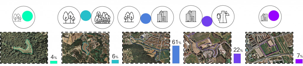
Abandoned crops categorization
Finally, we used the connectivity data to design a 3D model and to visualize the most intense connectivity paths. This allowed us to choose the ecological corridor and the alternative paths that have a better performance. The main objective of the corridor is therefore to connect the main natural areas, located in the north, Sant Llorenc del Munt i l’Obac Natural Park, and the south, Serralada Marina Natural Park and Collserola Natural Park, and the two rivers the Caldes River and the Ripoll River.
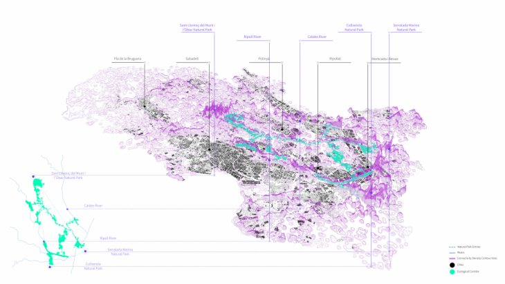
Connectivity 3D model
The corridor and its interventions
Actions
To enhance the pollination ecological corridor, there are four main actions expected to be implemented:

Actions to enhance pollination
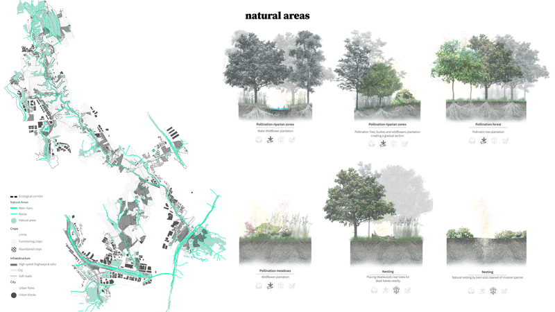
- Adequation of the environment: It tries to eliminate the adverse effects that the current situation of the areas in the corridor creates (such as management of invasive species or the reduction of chemical pesticides)
- Plantation: Selects the amount of wild autochthonous vegetation species that are suitable for our specific corridor and perfect for pollination, divided into three types (trees, high bushes, and wildflowers).
- Nesting: Creation of nests for pollinators that go from more artificial ones (like insect hotels) to more natural ones (cleaning areas for bare soils in sunny spots)
- Beekeeping: New productive areas for the production of honey on abandoned crops.
Interventions
We must consider that besides choosing the corridor due to the possibility of its high ecological performance, on the other hand, the areas to intervene are not necessarily the optimal ones. These areas should be reconverted to enhance pollinators by implementing the actions mentioned before, in order to create new ecologies to restore the degradation of the landscape and soils created by human action (such as the abandoned crops) and also, in areas that ecosystem services never seemed to be a possibility (such as in urban areas or infrastructure borders).
Taking into account the different types of layers that compose the elements to be transformed in our ecological corridor, we created a catalogue of interventions to be implemented based on the four kinds of actions described.
Catalogue of interventions
- Natural areas: During the last years, as agrarian areas have been started to be abandoned, a certain type of forestry has grown in Catalunya. Nevertheless, this type of forestry is more focused on invasive species and non-pollination trees and bushes that don’t promote pollination in our territory.
- Functioning crops: We need to engage farmers to stop using chemical pesticides and herbicides and create more biodiverse friendly agriculture: On one hand, that they promote pollination on the edges of crops and, on the other hand, to create pollination lines and patches inside them.
- Infrastructures: Borders of infrastructure are an opportunity to reconvert the actual oversimplified functionality that they provide, by creating a pollination infrastructure to enhance pollination connectivity.
- Urban areas: Pollinators always have demonstrated interest in our built environment rather than in our built landscapes of agriculture. We promote more self-sufficient parks -that don’t need such big maintenance- by accepting the wilderness of nature into them so they can provide the pollination ecosystem services is one of the actions. Buildings are also necessary objects to discuss because they can introduce the vertical plane (with facades) and a new elevated horizontal layer (the rooftops). Citizens can be easily enhanced to restore their own building by adding the vegetation layer to them.
- Abandoned crops: These degraded areas are the ones that actually help to create the continuity of ecological connectivity and the optimal ones for a complete restoration. The areas should have the implementation of the 4 kinds of actions, including the beekeeping activity due to its condition of unproductiveness as a new way of giving economic value to the ecosystem service we want to provide.
The Polypla Project
The Polypla project is a strategy to engage different typologies of stakeholders into the implementation and consolidation of the pollination corridor. The aim of the Polypla is to be built by different stakeholders and communities in a participatory way, that can go to the different areas that compose the corridor and build them by themselves. In order to achieve this goal, the Polypla project is based on different types of pollination starter kits that target different stakeholders and a municipal initiative that focuses on the development of solutions for abandoned crops.
Starter kits
The stakeholders to be engaged are the citizens, the schools, the industries, the farmers, and the municipalities. Each stakeholder has its own starter kit due to the fact that not all the actions can be made by everyone. For example, farmers are the only ones that can stop using chemical pesticides, or municipalities are the only ones that can change the section of the streets to put flower pots in the parking lanes. Besides the stakeholders, we have to take into consideration the abandoned crops as the heart of our project and we created a special starter kit for them. The aim is to engage the different stakeholders in these specific abandoned lands.
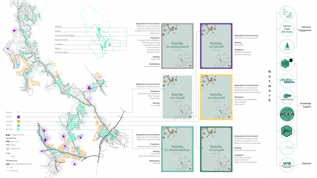
Stakeholders map
To promote these starter kits and the collective and individual actions, we opted to use the existing pollination network, including new actors that could be part of it. This network should be the one that can make the diffusion of the starter kit and engage people; give knowledge, support, and the necessary technology and do the research related to the ecological corridor that can promote the ecosystem services that the new landscape will create.
Case study: stakeholders starter kit for schools
Here we have an example of one of the stakeholders involved in our project: the schools. We identified the schools that are at a maximum of 500 meters distance to the nearest abandoned crop. The starter kit would show the actions that the kids -with the support of the teachers- could do: plantation of pollination wildflowers, create and distribute natural compost and build recycled insect hotels, all of them choose from our catalog of interventions explained before.
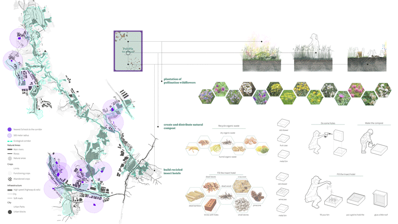
Schools starter kit
We chose one of the schools, the Juan Ramón Jimenez School, to design an itinerary that would be a maximum of one kilometer and that have different types of potential areas to intervene: a park, an abandoned crop, and a natural area. This itinerary has been created so the students of the Juan Ramón Jimenez school could go to the nearest park, the nearest abandoned crop, and the nearest natural area to make the interventions proposed in the starter kit: to plant, fertilize and put insect hotels that were previously built by themselves.
Polypla municipal initiatives
Besides the aforementioned starter kits for each stakeholder, the proposal also counts on the Polypla municipal initiative. In fact, the starter kits rely on the initiative of each stakeholder to promote pollination-friendly activities, especially in areas that are not abandoned crops.
The Polypla initiative represents an open competition where municipalities call for nonprofit organizations to make a proposal about a temporary use for an abandoned crop. In this way, the winning associations will have the responsibility to manage temporarily the crop and at the same time the opportunity to use the crop for their own activities. The initiatives will promote activities in the field of education, leisure or recreation, environmental or landscape, social or community, or similar. Beyond that, each project will have to be economically self-sufficient, include environmental sustainability criteria, be creative and innovative, and have a relevant impact and social performance. Finally, they will count on the support of the network and the collaboration of all the stakeholders that want to engage on a larger project with a larger impact.
Abandoned crops selection
In order to select the first group of abandoned crops, the intensity of potential connectivity has been used to select 8 of them. Each of them can be categorized based on the surrounding area, indicating which kind of intervention is more suitable or the right timing to apply different interventions. While abandoned crops within the city might require a larger intervention and maintenance of humans, abandoned crops close to natural areas might just require initial adequacy and afterward step back and let nature manage itself.
As part of the development of the project, the starter kit for abandoned crops has been developed to see the potentiality of the document. After a first block focus on communicating the relevance of pollination and the characteristics of the Polypla initiative, the document will provide interesting and practical information that will allow each stakeholder to get involved as much as desired. To close the document, the final block will just show the contribution of each stakeholder, showing how each of them has an important role, small or big, but required.
The entire document is accessible by clicking the following link: Polypla for abandoned crops Starter Kit
Conclusions
The project presents a high flexibility level in terms of implementation since there are short-term and long-term interventions, artificial and nature-based solutions, individual, collective, and more institutionalized interventions. It is the best way to reach a large impact on the collaboration of everyone who wants to participate. In the end, the aim of the entire project is to increase awareness and engage the whole society to make its part regarding the need to protect pollinators and their habitat, understanding that protecting them means protecting the future biodiversity of our natural ecosystems.
Flowerpowder: a new ecological corridor for pollinators is a project of IAAC, Institute for Advanced Architecture of Catalonia developed at Master in City & Technology in 2020/21 by student: Adriana Aguirre Such, Simone Grasso, Matteo Murat, Riccardo Palazzolo Henkes, and faculty: Eduardo Rico, Mathilde Marengo & Iacopo Neri.