Master in City & Technology 2019/20 – Term III
Seminar Name: Digital Tools & Big Data III – Big data and Simulation
Total Hours: 20 hours
Faculty: Diego Pajarito
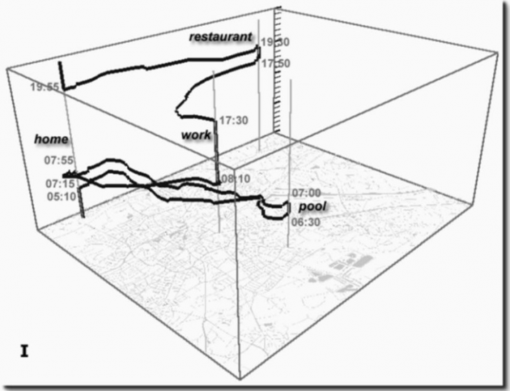
The space-time cube for a single person. In paper by E. Dolaciho B., H. Laksmiwati and Y. Widyani in IEEEXplore
Course Abstract
Big data is neither an isolated discipline nor the last step in the analysis. The vast amount of tools used in big data are also the building blocks of strong analysis processes within organizations. Due to the complex nature of the urban analysis, there are multiple disciplines and approaches involved. Advanced architecture techniques consider digital tools a fundamental piece when it comes to urban design and, therefore, big data techniques as part of the overall arrangement. This third and last part of the course on digital tools and big data looks for the integration of big data and simulation within urban design. The course is planned and executed together within two other courses of the third term, the main master seminar and the course on design tools.
Considering the multiple interfaces existing between big data analysis and other disciplines, this course will explore the bi-directional links between analysis and simulation. Additionally, using the common baseline of digital tools for the two disciplines, students will gain experience in establishing workflows to integrate tasks such as data collection, cleaning, evaluation and interoperation.
The aim of the course is composed of two specific goals. First, to gain experience in the evaluation and preparation of datasets needed to simulate urban issues through big data techniques (e.g., capture, clean, format and visualise). And second, to analyze the spatial and temporal dimensions of datasets describing urban dynamics (e.g., satellite images, spatial, socio-economic and demographic indicators).
The course starts with a review of the data commonly used to evaluate physical changes in the urban environment as well as the tools and algorithms used to estimate those changes. Later, the course will analyse the trends and spatial dispersion from historical official data, commonly used in urban design, with a combination of advanced analytics techniques and contrasts against the insights coming from crowdsourced datasets.
The second part of the course will align with individual approaches derived from the master studio sessions. At this point, students will build and implement and strategy to streamline the previously acquired skills and project-specific techniques under the orientation of the faculty. A final set of exercises will provide a wider perspective of big data tools used in professional scenarios (e.g., linked data, resource optimization, cloud services, among others) to prepare students for the future challenges.
The course ends up the series of courses lying between data science and advanced architecture. These courses offered a broad combination of concepts and applications and set the foundations for future research carried on by cities. The students of the Master in City and Technology would certainly put their hands on state-of-the-art techniques during this last year.
Faculty

Diego Pajarito got his PhD in Geoinformatics as part of a Marie Curie ITN Action – Joint doctorate between the Universities of Münster, Universitat Jaume I and Universidade Nova de Lisboa (2018), and the MSc in Information and Communication Sciences from Universidad Distrital de Bogotá (2014). He has performed research for the spatio-temporal analysis of sustainable transport and other urban systems as well as for data collection techniques through mobile devices and crowdsourced data collection. Diego’s interests are the simplification of data collection and analysis for non-expert audiences when it comes to considering it within a geographical context. He has been a lecturer of courses on spatial analysis, big data and spatial databases in Colombia, Universidad Distrital (2010-2015) and Universidad Autonoma de Bucaramanga (2014). He has also been a consultant for geospatial analysis and high-performance computing for different agencies in Colombia such as the Ministry of Agriculture (2010-2015), Institute of Environmental, meteorological affairs (2010, 2012, 2014), Ministry of Justice (2014), Geographical Institute (2007-2010), among others. Daniel is the “Data Scientist” of IAAC’s Advanced Architecture Group and seminar faculty of the MaCT.
