London Links
The London Green Links project aims to optimize the city’s urban fabric by providing more green space and improving connectivity between blocks with green pedestrian links.
This is achieved by a series of computational operations which explore many options, compare them and look for the best optimal solution. The main tools used in this optimization are Grasshopper and Wallacei X plugin for the optimization process.
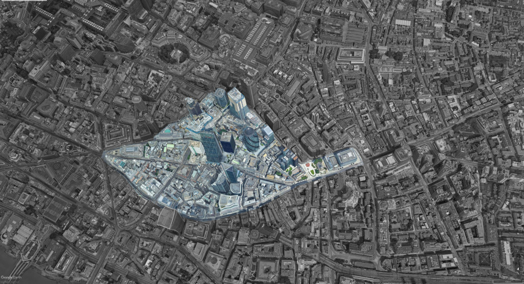
Selected urban morphology
For the purpose of this study, we chose a site in the centre of London. The urban fabric is characterized by high density, little green open space and a number of highrise towers.
Project objectives
The aim of the project is to optimize the urban fabric, massing and solar exposure while maintaining the existing total built area. In addition, one of the main goals is to achieve the highest possible open and green spaces while ensuring accessibility and optimal connectivity to all newly generated buildings.
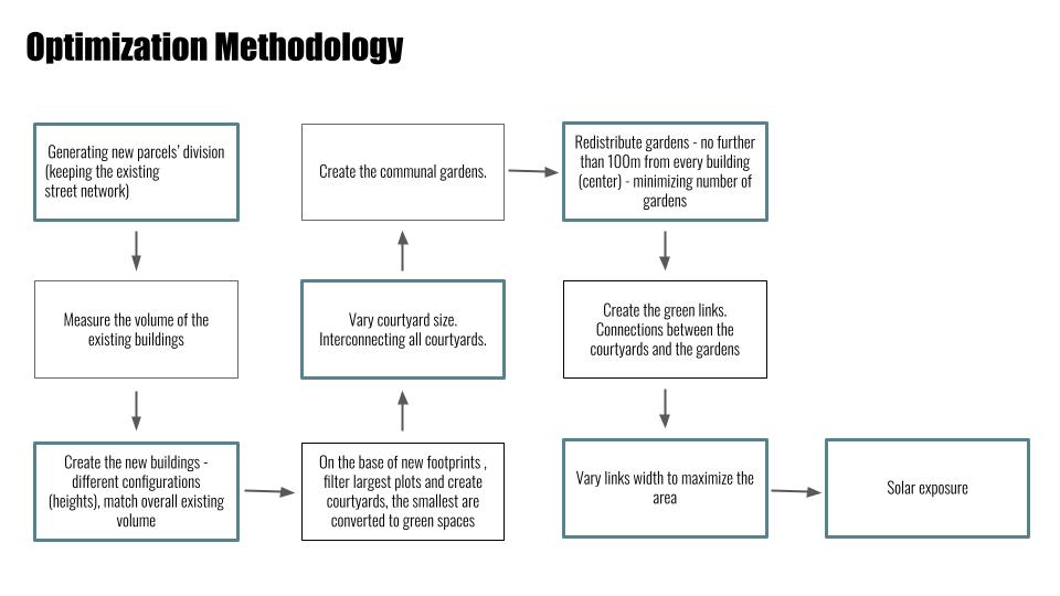
Methodology – Grasshopper code
The first step in the process is generating new plots, these were based upon existing main road networks to maintain the general structure of the site. Each mega-plot is optimized to generate 5 subplots achieving the shortest walk across the boundary of the mega-plot.
From the newly generated plots, the algorithm filters the smallest plots (in area) and directly converts these into parks (where the area is too small to be fit for a building). It also filters the largest plots (larger than a specified area) and applies internal courtyard for these. This creates more semi-public green space and provides greater variety in urban forms.
In order to optimize solar exposure (allowing maximum sunlight to reach the ground plane), the algorithm is able to iteratively test different building heights while maintaining the same total volume. At the same time, the size of the inner courtyards is also changing to allow for maximum exposure.
To improve connectivity, the courtyards are linked through a shortest path component which breaks through the urban fabric and allows maximum walkability. To take pedestrian connectivity to the next level, a “third level” of green links is introduced. The algorithm ensures that every building has an elevated community garden within 100 m walk. As these gardens are iteratively being placed, elevated green links are generated between them. The width of these bridges is also controlled by solar occlusion to ensure optimal exposure is maintained on the ground level.
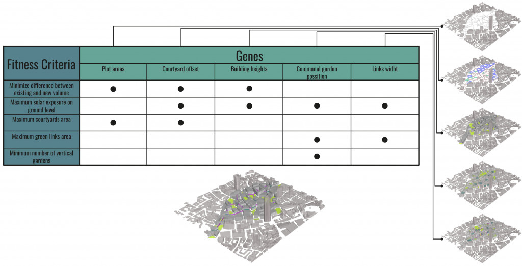
The fitness objectives
In our code we used 6 objectives:
- Optimize massing while maintaining existing total volume
- Optimize massing to improve solar exposure
- Optimize plot sizes to achieve better walkability & Connectivity
- Increase green space by introducing courtyards within larger plots
- Introduce communal gardens within 100 m walk from every building
- Introduce elevated green links between courtyards and communal garden

The evolutionary matrix
The evolutionary matrix demonstrates the relationship between the different variables (gene pools) and the set fitness objectives. This also illustrates how some variable control the growth and iteration of several objectives at the same time while others limit this growth providing a constructive conflict.
The results of the evolutionary simulation
We begin with the optimization for 2 objectives, to test if there are enough constructive conflicts happening inorder to perform this evolutionary optimization. After few success optimized outputs we start to test with more objective, to achieve the project proposal. The test till the first three objectives is optimized in a better way. The standard deviation was moving towards the left and optimizing the gene pool. And the mean value was having a gradual drop. When the tool was feeded with the all 6 objective we noticed a huge conflit and the system was not optimizing over the gene pool.

During the troubleshooting, we figured out that the gene pool was static when the first objective was trying to find the best combination for the area distribution. We had to reprocess the length of the gene pool like in nature to just activate the required number of genes for the tool to create a set of genomes. After this process, we had to reduce one of the objectives to maintain the largest area for the parcels, but still have the gene pool connected to Wallacei to optimize the process
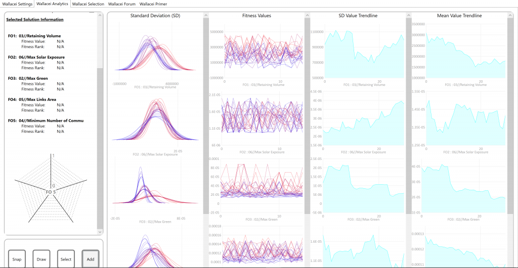
This evaluation process was working better for our proposal. After this process we moved to the selection criteria to see which set of gene pools works better for the final proposal for the location. This selection does not give one specific output, we categorize them and compare the end results and to have a set of selection and the post process can determine the best option or proposal for the study area.
Post validation and analysis of the selected urban morphology
After running the numbers of simulations we chose the optimized solution and compared it to status quo. The value of volume stayed almost not changed. The green space area increased more than 13 times and the solar occlusion improved too.
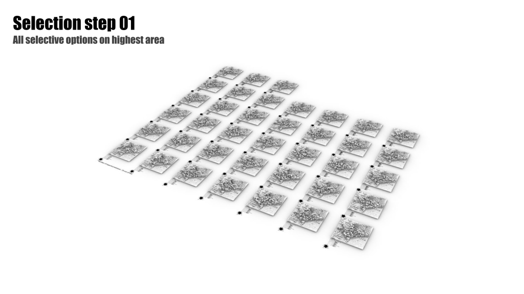
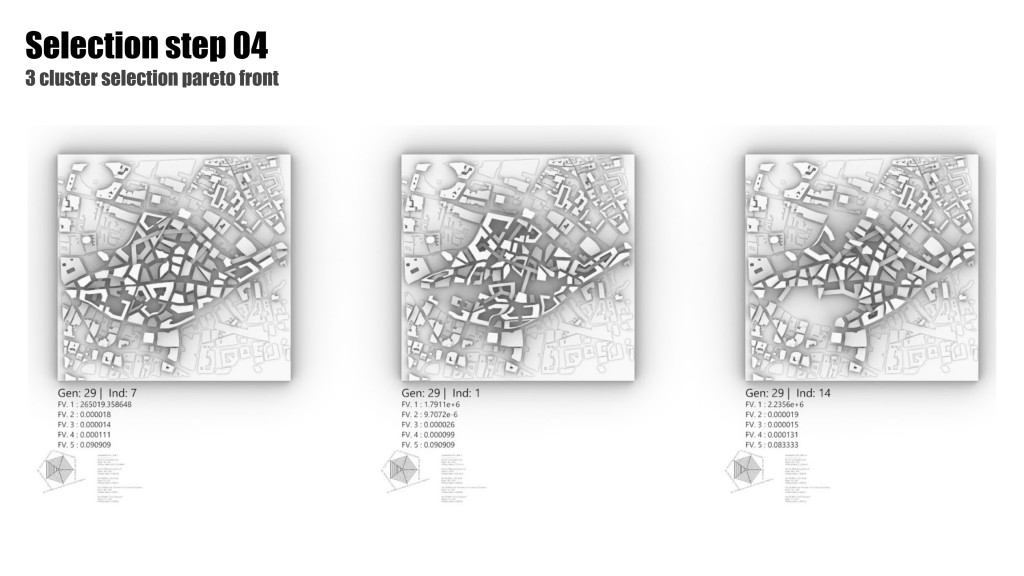
These are the first list of 38 optimized green area solutions. After this we clustered the group into 3 groups to see the variance based on this. In parallel comparing it with pareto fronts. In the end we could define the top 3 options from the generation 29, which has the optimized characteristics for all our 5 objectives defined.
London Links is a project of IAAC, Institute for Advanced Architecture of Catalonia developed at Master in City and Technology in 2020/2021 by Students: Leyla Saadi, Marta Galdys, Sridhar Subramani and Faculty: Milad Showkatbakhsh