INTRODUCTION
At a global scale, the challenges of the food system are generally associated with feeding the world’s growing population. The one thing more significant than the growth, is the dynamism of the population that is shifting in character from predominantly rural to increasingly urban. The urban population of the world has grown rapidly from 751 million in 1950 to 4.2 billion in 2018. Today, upward of 55% of the world’s population lives in urban areas, a proportion that is expected to increase to 68% by 2050. As it is reported by the United Nations Department of Economic and Social Affairs, the projections show that urbanization, the gradual shift in residence of the human population from rural to urban areas, combined with the overall growth of the world’s population could add another 2.5 billion people to urban areas by 2050.
Food for Future aims to develop a generative model enabling adaptive reuse of both underground car parks and urban empty lots. Considering that underground car parks are becoming future cemeteries of cars and are not subject to any planning processes today, it is one of the main objectives of the project to re-add value to these areas. Together with surface car parks they are considerably large areas for agricultural food production. In addition to the re-use of future vacant lands, FFF anticipates providing transition between underground and surface with the help of proposed open holes. They are also expected to provide a consistency of street section and makes underground visible.
METHODOLOGY
The project initially focuses on the surroundings of Sagrera Metro Station which is now a days is home to the largest rail and urban-planning regeneration in Spain.
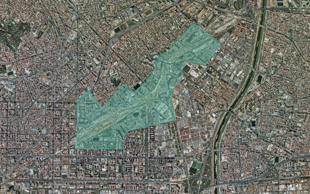
Location in Sagrera station
With the ongoing project for train station and its surrounding, the city will gain diversified housing options as well as new facilities and public services. It also offers many economic and retail activities, and the largest linear urban park in the city. Sagrera Train Station will be an intermodal transport hub, well-connected with the rest of the city and its surroundings. Within the boundaries of the study area, there are 5 different neighborhoods that are analyzed both separately (as the parts of a whole) and undividey (as one single area) which are el Bon Pastor, la Sagrera, Sant Martí de Provençals, la Verneda i la Pau and Sant Andreu.
CONCEPT
Due to the future predictions that we have mentioned before, on one hand the population in Barcelona city will grow and the demand of local food will increase and, as an urban consequence, there will be an exponential need for space. On the other hand, new technologies will enable to free the city from the spatial injustice that private car transport creates, and unused lots will be reconsidered in the future strategic plans. This will mean that surface parking lots, underground parks, vacant lands, and brownfields will offer new spaces for new uses, such as local agriculture production.
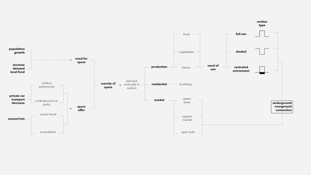
Nevertheless, this space on the surface will not be able to absorb all the new necessities of the future, and therefore a planned verticality in section will become the motor idea for the project. This new verticality is proposed to happen underground but also in the underground part of the city in order to promote it, as it has always been an unrecognized space.
The new section of the city will respond to three different type of programs: markets for the locally produced food (for green areas and first floor of open holes and the Sagrera Station as the main market), residential buildings (for the population growth) and the food production.
The food production is characterized by its environmental needs, and the sun is the primary one. 47 types of vegetables, fruits and beans were clustered in three different groups depending on the hours of sun needed: full sun (from 8 to 6 hours), partial sun or shaded (from 6 to 4 hours) and controlled environment agriculture (no need for sunlight). A different type of section was proposed for each cluster in order to provide better environmental conditions for each type of plant:
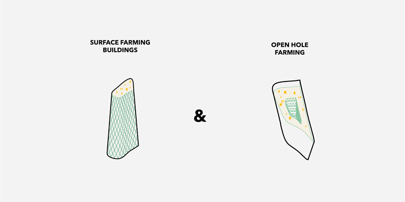
- For the full sun plants a surface building farming was proposed.
- For the shaded or partial sun need plants open holes in the ground.
- For the controlled environment, the reuse of underground parking lots.
In the end, new connections were provided between the production places and the new marketplace to provide a permeable system of food and people movement.
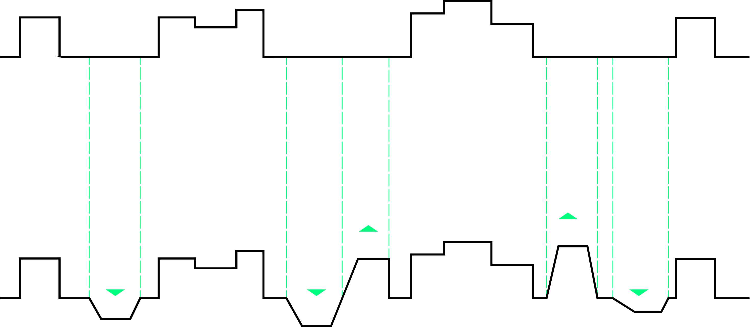
Changing the city section
SIMULATION
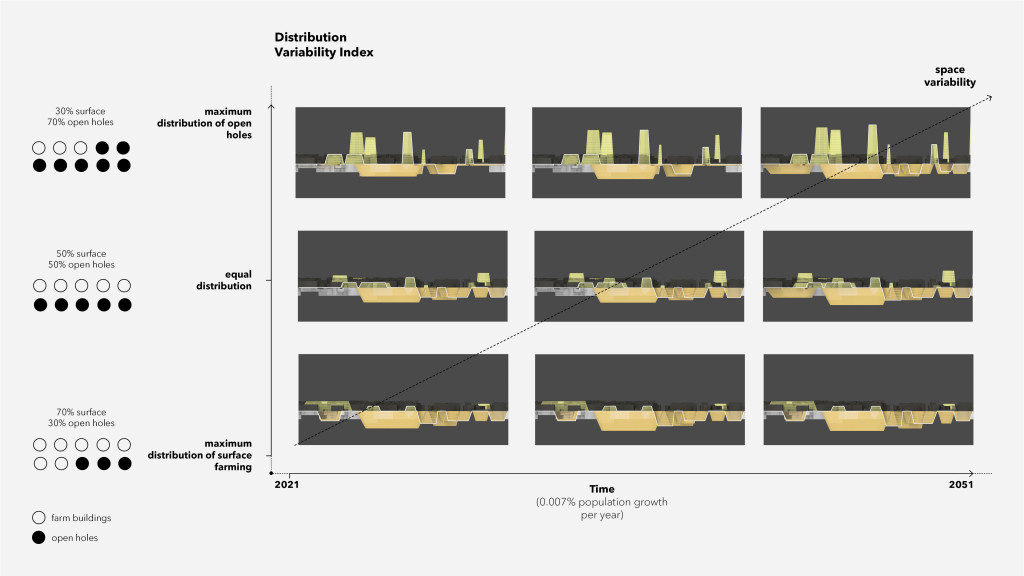
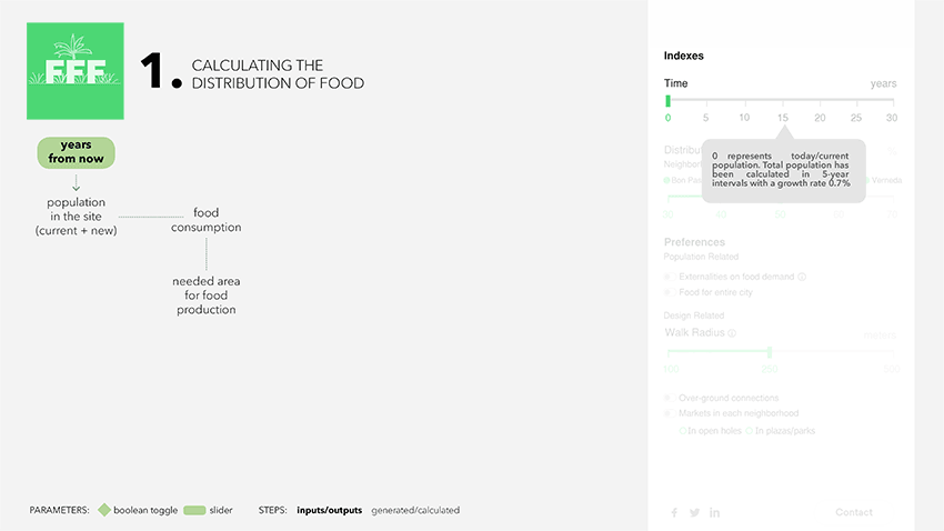
Main parameters
In order to obtain the up ground and underground vertical section, there are two main parameters on which the created algorithm is based. The first one is the time based on the population growth estimation. The second one is the DVI or Distribution Variability Index that distributes the different typologies of farms. An equal distribution supposes the same number of open holes and surface farming buildings and this parameter allows to choose between maximum distribution of open holes (70% of open holes and 30% of surface farming buildings) and maximum distribution of surface farming buildings (30% of open holes and 70% of surface farming buildings). The percentages have been chosen as a design decision since they give more feasible results and eliminate the outlier extreme results from the program.
Main parameters
Procedural Geometry and Data Generation
Grasshopper was used to generate a complex calculator and simulator of food production, which was later simplified on the User Interface by displaying just the changeable parameters (image on the left). These parameters together with the data collected which was imported into the software represent the inputs of the code. From them, the space needed for food is calculated as well as the typologies needed for these spaces. In other words, the area needed for producing food in full sun, in partial sun and in controlled environment on the underground. The spatial visualization is also generated with the inputs, and by combining it with the calculation of farm typologies needed, the output is our vision for the city. Additional elements, such as housing to accommodate the growing population, open markets for selling the food and connection between the new elements are generated through the same process of visualization and calculation from the data collected combined with the changeable parameters.
Grasshopper code & interface
Therefore, the user is firstly able to play with the Time and the Distribution Variability Index, the main parameters previously shown, which increase the population and change the distribution of typologies, respectively. The DVI changes the amount and location of lots used for surface farming and open hole farming, but it also influences on the underground farming typology, due to the fact that the underground parking lots chosen to become farms are always the ones closest to the new open hole farms, in order to provide connections on the underground.
Design Process
The three farming typologies previously mentioned consist in two new types of buildings and one reuse of existing constructions. For the Surface Farming Buildings, the chosen parcels are firstly extruded upward, with the exact height needed for producing the total amount of food, with different heights for each based on the size of the lots, being the biggest lot the highest building. Thereupon, an organic form is created through reshaping the block by smoothening its lines and scaling down the last floor. For the final steps, details are added, such as the new amount of floors and a glass façade. The same process is done for the Open Hole Farming, with some changes: instead of up, the parcel is extruded downward, with no façade treatment and with a central patio added in every floor, including the first one which consists of a public plaza instead of a floor for farming. Lastly, the underground parking lots needed to provide the area of underground farm calculated are then transformed for this purpose.
An additional design element is the underground passages connecting the underground farms to the open hole farming and the Sagrera Station market, as well as the overground passages connecting the surface farming buildings with the new residential ones, which is an optional feature on the UI.
Design space & Output
By default, the interface considers current population (time 0) and takes the DVI 50% for each neighbourhood. The walk radius from residential units to the markets is considered as 250 meters in default settings and all other preferences are not taken into account.
- The interface primarily reveals the changes caused by the increasing population over the years. These changes are, inevitably, the appearance of new residential buildings and – when all other parameters are kept as default – the inclusion underground farms in the design process to meet the demand of growing population.
- When externalities on food demand is evaluated with a sharper increase in population, it is seen that underground and surface farms are utilized more effectively.
- When all other parameters are kept constant and only the walk radius from residential units to the market – which is located on only Sagrera Metro Station by default – is reduced, it is seen that the farms are concentrated at certain points, so higher vertical and deeper underground farms appear. On the other hand, residential units become more spread along the entire site.
- Unlike the previous scenario, if the walk radius is raised above the default settings, it is seen that residential units are concentrated at certain points and the farms begin to spread along the entire site.
- As a preference, when the marketplaces are chosen to be located in each neighborhood (either in the parks/plazas or open holes) the design intervention of the simulation becomes more visible that is locating marketplaces near by the closest farm in all neighborhoods.
- As another preference, users have the option to include over-ground connections into the interface.
- When the DVI is decreased below the default settings, the variety of type of farms becomes less varied thus, the users see fewer open holes and more surface farms in selected neighborhoods.
- When the population is calculated for 30 years from today, it is seen that the density of residential units increases, and the farms rise or deepen accordingly.
- When the DVI is raised above the default settings, the variety of type of farms becomes less varied, again, so the users see more open holes and less surface farms in selected neighborhoods. So, the heights of particular types change accordingly.
- When the walk radius is set to the maximum value (500 m) there will be an extreme density of residential units on particular areas.
DEMONSTRATION
To sum up, we envision Sagrera Station, as a paradigm and a launching point of our simulator and overall proposal, influencing the urban environment in the first place but moreover affecting eating habits of the local population. Bringing food production inside the city does not only work in the direction of raising awareness about the importance of local food production, but furthermore contributes to a greener, sustainable and participatory urban environment.
Food For Future is a project of IAAC, Institute for Advanced Architecture of Catalonia developed at Master in City & Technology in 2020/21 by students: Sinay Coskun, Laura Guimarães, Diana Roussi and Adriana Aguirre Such and faculty: Alex Mademochoritis, Eugenio Bettuchi & Iacopo Neri