CERDA DATA: CITY PLANS
Project of Laura Marcovich
Iaac – MaCT 2016
Faculty: Vicente Guallart, Marta Mila and Andre Resende
City Plans
Is a small study into the different urban plans studied for main cities expansions during the 1800´s.
During this years, new modern social theories and industrialization marked the start of new urbanism theories.
My hypothesis builds upon the phrase “when you hit rock bottom the only way is up”. Meaning essentially that major cities renovations and improvements were the resulting solutions after they experienced severe epidemic crisis and the influences of the industrial revolution in their economy.
Beginning with a timeline to evidence the epidemics and city planning renovations in the different cities, passing by various city plans analysis, all the way to visualizing some of Cerda’s data and his comparisons, I will try to argument my hypothesis and recognize Cerda’s inspirations for his Ensanche proposal.
Timeline

New York
The formerly New Amsterdam Colony becomes New York British Colony in 1664.
In the late 1700’s NYC was a compact town at the southern tip of Manhattan, made of cramped irregular streets. It was the capital of the US. until 1970 when the capital was transferred to Philadelphia by G. Washington. However New York City remained as the economy center of the country, and it grew as a result of his port activities. Its strategic location connected the Atlantic port to the vast agricultural markets of the North American interior.
In the early 1800’s immigration resumed after being slowed by wars in Europe, and with it, a new street grid system was commissioned to expand to all of Manhattan. They were given 4 years to have the island surveyed, and then to produce a map showing the placement of future streets.
Established in 1811, a grid of 12 N-S avenues and 155 E-W streets became the new element of Manhattan that defines it to this day. It was the first great civic enterprise and a vision of brazen ambition.
Designed to provide orderly development, convenience, and health. Took around 100 years to be built.
Is only in 1847 when the concept of the Central park came up for public discussion by wealthy landowners and merchants, who argued that New York lacked the kind of parks that graced cities such as London and Paris, and that the creation of such a park would enhance New York’s reputation as an international city.
The truth is that with the population of the city growing, there was an intense need for public spaces, which the Commissioners’ Plan had been notoriously short on providing for.
Central Pak was included in 1950 and it’s by far the largest alteration to the Commissioners’ Plan. 341 ha between 59th and 110th Streets and Fifth and Eight Avenues.
Paris
In the mid-1800 illustrious characters like Voltaire and Victor Hugo described Paris as unlivable.
In 1845 the French social reformer Victor Considerant wrote: “Paris is an immense workshop of putrefaction, where misery, pestilence and sickness work in concert, where sunlight and air rarely penetrate. Paris is a terrible place where plants shrivel and perish, and where, of seven small infants, four die during the course of the year.”
In 1848 in the Arcis and Saint-Avoye neighborhoods, 5 to 10 percent of the population was dying to the cholera epidemic.
Traffic circulation was another major problem. The widest streets in the center of Paris were 5m wide, and the narrowest 1 or 2 m wide. So, during the first Republic Napoleon III (Luis Napoleon Bonaparte (the nephew)), inspired in London where he lived in exile, instructed Haussmann to bring air and light to the center of the city, to unify the different neighborhoods with boulevards, and to make the city more beautiful.
Some of the main renovations completed were Rue Rivoli, two new Boulevards, Strasbourg, and Sébastopol. Preparing for the Universal Exposition in 1855.
Together with the architect Mouner, they began a project which would transform the Bois de Boulogne (Boulogne Forest) into a large new public park, modeled after Hyde Park in London but much larger, on the west side of the city. And the Bois de Vincennes in the east.
In 1870, after intense criticism by Parliament, Napoleon III dismisses Haussmann. It’s a development of great controversy but Haussmann’s straight avenues continue to dominate Paris today.
Vienna
The vast glacis acted as a large belt between 800 and 1,400 meters wide and over 600 ha, that surrounded the wall which disconnected the old city from the suburbs. In the mid-1800’s it was used as a public walk and was furrowed only by tree-lined paths and kiosks.
In 1850, the districts II-IX got incorporated into the city. The existing walls are a great obstacle although the glacis (glaze garden) had become a recreational space.
In 1858 a contest was convened to urbanize the Ring, attended by many participants (about eighty). But although the contest was, none of these projects were implemented. They were reworked by a team of state architects led by Moritz von Lhoer.
The urban approach responded to the requirements of a modern city, attending to the intense traffic of vehicles, with a scale and scale unknown until then. The Ringstrasse is a large boulevard 4 kilometers long and 57 meters wide at the sides of which rises the extensive building program and parks.
With the Viennese performance, along with the transformations in the Baron Haussmann’s Paris and the ideal proposal in the Barcelona of Cerdá, was defining the character of the bourgeois city of the second half of the nineteenth century, the so-called Postliberal City.
The project received criticism from Camillo Sitte, the urban planning theorist who published book “City Planning According to Artistic Principles” was published in 1889 and was exceedingly influential. To Sitte, the plazas had to have an enclosed, human scale. Sitte advocated for an informal, picturesque composition, as well as an approach that was “artfully” choreographed.
Sitte even proposed changes to the Ringstrasse, attempting to arrest the linearity of the new boulevard and to capture space along its length.
The urban architectural work of Otto Wagner is very present within the context of the redevelopment of the Ringstrasse of Vienna. Wagner, on the other hand, embraced the new modern city. His buildings were in deference to the streets, inserted into the urban fabric. In this way, the buildings DEFLECTED and FACILITATED movement.
By 1870 the majority of public and private buildings were built.
London
There are many different urban patterns in London during the Georgian and Victorian years but not one that defines it. Cerda studied some of them.
London grew immensely during the industrial revolution around the 1700’s. It’s grid of railways, which was important for the city expansion and one of the biggest of the century along with NY’s.
I found very relevant that is in the late 1800’s where surveying starts being mapped.
In 1949 Dr. Snow theorized that cholera reproduced in the human body and was spread through contaminated water. This contradicted the prevailing theory that diseases were spread by “miasma” in the air.
In 1989 Charles Booth developed the English Poverty map of a slum in East End London. The streets are colored to represent the economic class of the residents: Yellow (“Upper-middle and Upper classes, Wealthy”), red (“Lower middle class – Well-to-do middle class”), pink (“Fairly comfortable good ordinary earnings”), blue (“Intermittent or casual earnings”), and black (“lowest class…occasional labourers, street sellers, loafers, criminals and semi-criminals”).
Cerda Data
Before developing the Plan for Barcelona Cerda realized some studies and surveys on his own.
He studied one of the first Grid Iron Concepts developed by Thomas Holme on Philadelphia in 1683.
As well as the cities in North America with the grid fomented by Jefferson, in South America, there were also orthogonal grids imposed since the Spanish Colony conquest. These were also an example for Cerda to study.
Data – Memoria y Atlas del Ensache de Barcelona
Ciutadella – Memoria y Atlas del Ensache de Barcelona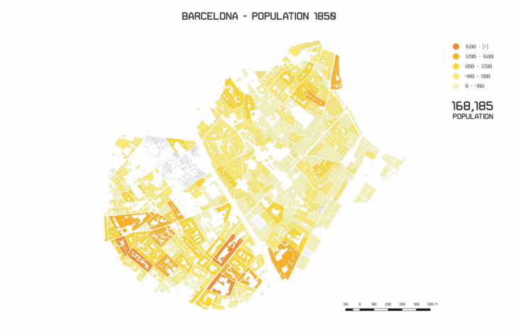

 Comparing the blocks of New York & Barcelona
Both cities are defined by the strong character of their grid, this character set the dynamics developed in them.
In the 1850’s the iron grid of NY was half way implemented and Barcelona starting to be planned.
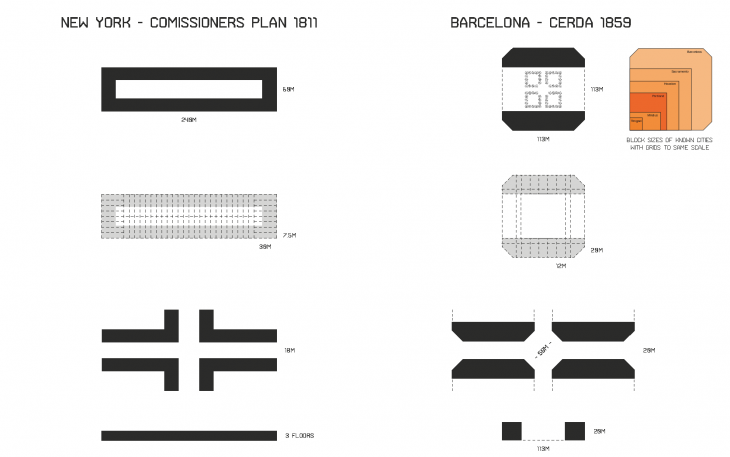 NY
NY
Blocks 60m x 190 – 280 m
Avenues 30.5 m wide
Streets 18 m wide
The Commissioners’ Plan did not in any way specify what the size of individual lots within the blocks should be, although the size and rectangular nature of the blocks lent itself to rectangular lots of equal size to fit into the block. The height was not defined, but around 1820 the height built was going from 2 to 4 floors.
BCN
Blocks 113 x 113 m
Avenues of 50 m wide
Streets from 20 – 30 m wide
Cerda was able to foresee the future of transportation systems and plan accordingly. Under the concepts of equity and health, he also gave way to high quality and enhanced lighting of the private and public spaces.
Due to different factors and different economic developments, each city performs differently. Today, NY is a city of higher density, one of the financial capitals of the world, however, Barcelona with it’s smaller scale is a leader for innovative planning in the world since the Ensanche plan of Cerda.
